
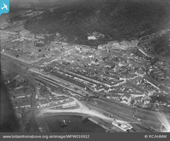
WPW016912 WALES (1926). View of Port Talbot, oblique aerial view. 5"x4" black and white glass plate negative.
© Copyright OpenStreetMap contributors and licensed by the OpenStreetMap Foundation. 2026. Cartography is licensed as CC BY-SA.
Nearby Images (14)
WAW005818

WAW033693

WAW033694

WAW033695

WPW000985

WPW000986

WPW000988

WPW016911

WPW016912

WPW006120

WPW006121

WPW006122

WPW029772

WPW029774

Details
| Title | [WPW016912] View of Port Talbot, oblique aerial view. 5"x4" black and white glass plate negative. |
| Reference | WPW016912 |
| Date | 1926 |
| Link | Coflein Archive Item 6378167 |
| Place name | |
| Parish | |
| District | |
| Country | WALES |
| Easting / Northing | 276530, 190220 |
| Longitude / Latitude | -3.7827955676634, 51.596802833336 |
| National Grid Reference | SS765902 |
Pins

gBr |
Wednesday 7th of January 2015 03:36:40 PM | |
|
gBr |
Wednesday 7th of January 2015 03:31:00 PM | |

Class31 |
Monday 17th of November 2014 12:53:12 PM | |
|
Class31 |
Monday 17th of November 2014 12:41:39 PM | |
|
Class31 |
Monday 17th of November 2014 12:41:08 PM | |
|
Class31 |
Monday 17th of November 2014 12:40:05 PM | |
|
Class31 |
Monday 17th of November 2014 12:38:47 PM | |
 |
Class31 |
Monday 17th of November 2014 12:33:28 PM |
|
Class31 |
Monday 17th of November 2014 11:59:31 AM | |
|
Class31 |
Monday 17th of November 2014 11:57:38 AM | |
|
sscoulding79 |
Tuesday 11th of November 2014 08:36:13 AM | |
|
Ifor |
Friday 18th of July 2014 12:19:22 PM | |
|
Ifor |
Friday 18th of July 2014 12:18:38 PM | |
|
Class31 |
Monday 21st of January 2013 11:33:41 PM | |
|
Class31 |
Monday 21st of January 2013 11:32:19 PM | |
|
Class31 |
Monday 21st of January 2013 11:30:35 PM | |
|
Class31 |
Monday 21st of January 2013 11:28:58 PM |


User Comment Contributions
This is a photograph of Briton Ferry not Port Talbot. The title needs changing and a revised map reference. |
Class31 |
Monday 21st of January 2013 11:35:16 PM |
This shows Briton Ferry and the docks. |
christaffy16 |
Sunday 21st of October 2012 06:10:55 PM |