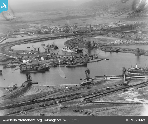
WPW006121 WALES (1921). View of Aberavon showing docks, oblique aerial view. 5"x4" black and white glass plate negative.
© Copyright OpenStreetMap contributors and licensed by the OpenStreetMap Foundation. 2026. Cartography is licensed as CC BY-SA.
Nearby Images (14)
Details
| Title | [WPW006121] View of Aberavon showing docks, oblique aerial view. 5"x4" black and white glass plate negative. |
| Reference | WPW006121 |
| Date | 1921 |
| Link | Coflein Archive Item 6370330 |
| Place name | |
| Parish | |
| District | |
| Country | WALES |
| Easting / Northing | 276290, 190130 |
| Longitude / Latitude | -3.7862273979739, 51.595941247229 |
| National Grid Reference | SS763901 |
Pins

sloyne |
Tuesday 26th of June 2018 12:00:14 AM | |

sloyne |
Monday 25th of June 2018 11:59:11 PM | |

sloyne |
Friday 8th of March 2013 10:58:25 PM | |

sloyne |
Friday 8th of March 2013 10:56:57 PM | |

sloyne |
Friday 8th of March 2013 10:55:39 PM | |

sloyne |
Friday 8th of March 2013 10:54:00 PM | |

sloyne |
Friday 8th of March 2013 10:52:44 PM | |

sloyne |
Friday 8th of March 2013 10:51:23 PM | |

sloyne |
Friday 8th of March 2013 10:50:17 PM | |

sloyne |
Friday 8th of March 2013 10:48:58 PM | |

sloyne |
Friday 8th of March 2013 10:47:52 PM |


![[WPW006120] View of Aberavon showing steelworks, oblique aerial view. 5"x4" black and white glass plate negative.](http://britainfromabove.org.uk/sites/all/libraries/aerofilms-images/public/100x100/WPW/006/WPW006120.jpg)
![[WPW006121] View of Aberavon showing docks, oblique aerial view. 5"x4" black and white glass plate negative.](http://britainfromabove.org.uk/sites/all/libraries/aerofilms-images/public/100x100/WPW/006/WPW006121.jpg)
![[WPW006122] View of Aberavon showing steelworks, oblique aerial view. 5"x4" black and white glass plate negative.](http://britainfromabove.org.uk/sites/all/libraries/aerofilms-images/public/100x100/WPW/006/WPW006122.jpg)
![[WPW029772] View of coast at Aberavon, oblique aerial view. 5"x4" black and white glass plate negative.](http://britainfromabove.org.uk/sites/all/libraries/aerofilms-images/public/100x100/WPW/029/WPW029772.jpg)
![[WPW029774] View of Aberavon, oblique aerial view. 5"x4" black and white glass plate negative.](http://britainfromabove.org.uk/sites/all/libraries/aerofilms-images/public/100x100/WPW/029/WPW029774.jpg)
![[WAW005818] General view of Port Talbot showing docks](http://britainfromabove.org.uk/sites/all/libraries/aerofilms-images/public/100x100/WAW/005/WAW005818.jpg)
![[WAW033693] General view of Port Talbot showing docks](http://britainfromabove.org.uk/sites/all/libraries/aerofilms-images/public/100x100/WAW/033/WAW033693.jpg)
![[WAW033694] General view of Port Talbot showing docks](http://britainfromabove.org.uk/sites/all/libraries/aerofilms-images/public/100x100/WAW/033/WAW033694.jpg)
![[WAW033695] General view of Port Talbot](http://britainfromabove.org.uk/sites/all/libraries/aerofilms-images/public/100x100/WAW/033/WAW033695.jpg)
![[WPW000985] General view of Port Talbot showing docks and steelworks, oblique aerial view. 5"x4" black and white glass plate negative.](http://britainfromabove.org.uk/sites/all/libraries/aerofilms-images/public/100x100/WPW/000/WPW000985.jpg)
![[WPW000986] General view of Port Talbot showing docks, oblique aerial view. 5"x4" black and white glass plate negative.](http://britainfromabove.org.uk/sites/all/libraries/aerofilms-images/public/100x100/WPW/000/WPW000986.jpg)
![[WPW000988] General view of Port Talbot showing docks, oblique aerial view. 5"x4" black and white glass plate negative.](http://britainfromabove.org.uk/sites/all/libraries/aerofilms-images/public/100x100/WPW/000/WPW000988.jpg)
![[WPW016911] View of Port Talbot showing Taibach and Talbot Memorial Park in Distance, oblique aerial view. 5"x4" black and white glass plate negative.](http://britainfromabove.org.uk/sites/all/libraries/aerofilms-images/public/100x100/WPW/016/WPW016911.jpg)
![[WPW016912] View of Port Talbot, oblique aerial view. 5"x4" black and white glass plate negative.](http://britainfromabove.org.uk/sites/all/libraries/aerofilms-images/public/100x100/WPW/016/WPW016912.jpg)