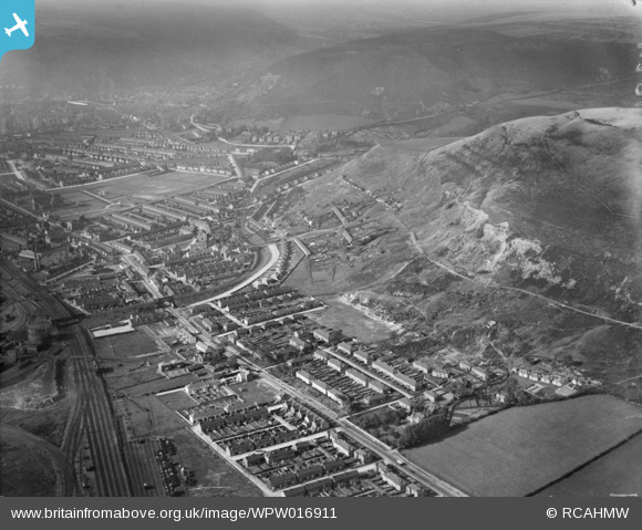
WPW016911 WALES (1926). View of Port Talbot showing Taibach and Talbot Memorial Park in Distance, oblique aerial view. 5"x4" black and white glass plate negative.
© Copyright OpenStreetMap contributors and licensed by the OpenStreetMap Foundation. 2026. Cartography is licensed as CC BY-SA.
Nearby Images (14)
WAW005818

WAW033693

WAW033694

WAW033695

WPW000985

WPW000986

WPW000988

WPW016911

WPW016912

WPW006120

WPW006121

WPW006122

WPW029772

WPW029774

Details
| Title | [WPW016911] View of Port Talbot showing Taibach and Talbot Memorial Park in Distance, oblique aerial view. 5"x4" black and white glass plate negative. |
| Reference | WPW016911 |
| Date | 1926 |
| Link | Coflein Archive Item 6378168 |
| Place name | |
| Parish | |
| District | |
| Country | WALES |
| Easting / Northing | 276530, 190220 |
| Longitude / Latitude | -3.7827955676634, 51.596802833336 |
| National Grid Reference | SS765902 |
Pins

gBr |
Monday 16th of November 2015 09:16:02 PM | |
|
Steaming_Chris |
Monday 16th of March 2015 04:20:29 PM | |
|
Steaming_Chris |
Monday 16th of March 2015 04:19:40 PM | |

Class31 |
Sunday 25th of November 2012 09:22:17 PM | |
|
Class31 |
Sunday 25th of November 2012 09:20:15 PM | |
|
Class31 |
Sunday 25th of November 2012 09:19:23 PM | |
|
Class31 |
Sunday 25th of November 2012 09:18:35 PM | |
|
Class31 |
Sunday 25th of November 2012 09:15:57 PM | |
|
Class31 |
Sunday 25th of November 2012 09:15:01 PM | |
|
Class31 |
Monday 12th of November 2012 08:01:55 PM | |
|
Allan |
Monday 30th of July 2012 05:56:11 PM |