
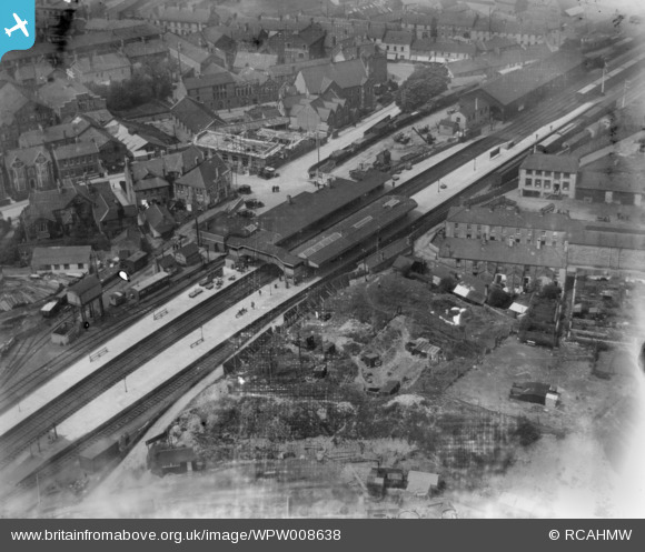
WPW008638 WALES (1923). View of Bridgend showing railway station, oblique aerial view. 5"x4" black and white glass plate negative.
© Copyright OpenStreetMap contributors and licensed by the OpenStreetMap Foundation. 2026. Cartography is licensed as CC BY-SA.
Nearby Images (28)
WAW006828

WAW006829

WAW006830

WAW006831

WAW006832

WAW006833

WAW039128
. Oblique aerial photograph, 5½\" cut roll film.")
WAW039129
. Oblique aerial photograph, 5½\" cut roll film.")
WAW039130
. Oblique aerial photograph, 5½\" cut roll film.")
WAW039131

WPW008636

WPW008637

WPW008638

WPW008639

WPW008640

WPW029401

WPW029402

WPW029403

WPW029404

WPW029405

WPW029406

WPW029407

WPW029408

WPW029409

WPW029410

WPW029411

WPW038314

WPW038317

Details
| Title | [WPW008638] View of Bridgend showing railway station, oblique aerial view. 5"x4" black and white glass plate negative. |
| Reference | WPW008638 |
| Date | 1923 |
| Link | Coflein Archive Item 6370378 |
| Place name | |
| Parish | |
| District | |
| Country | WALES |
| Easting / Northing | 290565, 179834 |
| Longitude / Latitude | -3.5769987719446, 51.506345252149 |
| National Grid Reference | SS906798 |
Pins

IanGardiner |
Sunday 14th of February 2021 04:57:43 PM | |
|
MB |
Thursday 21st of January 2021 05:17:24 PM | |
|
MB |
Thursday 21st of January 2021 05:13:28 PM | |
|
MB |
Thursday 21st of January 2021 05:12:47 PM | |
|
MB |
Thursday 21st of January 2021 05:11:38 PM | |
|
kent |
Sunday 15th of July 2012 01:47:25 PM | |
|
kent |
Sunday 15th of July 2012 01:43:32 PM | |
|
ddj |
Monday 2nd of July 2012 06:41:15 AM |
User Comment Contributions

Bridgend Station, 20/05/2009 |

Class31 |
Monday 10th of November 2014 12:07:25 PM |