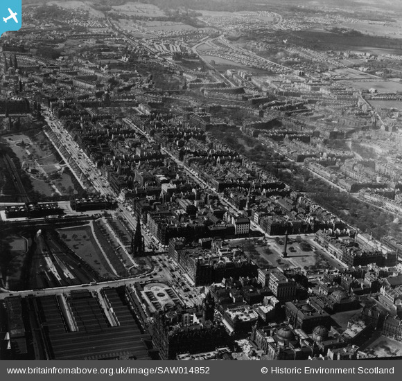
SAW014852 SCOTLAND (1948). Edinburgh, general view, showing Princes Street and Queen Street Gardens. An oblique aerial photograph taken facing west. This image has been produced from a print.
© Copyright OpenStreetMap contributors and licensed by the OpenStreetMap Foundation. 2026. Cartography is licensed as CC BY-SA.
Nearby Images (24)
Details
| Title | [SAW014852] Edinburgh, general view, showing Princes Street and Queen Street Gardens. An oblique aerial photograph taken facing west. This image has been produced from a print. |
| Reference | SAW014852 |
| Date | 1948 |
| Link | NRHE Collection item 1314763 |
| Place name | |
| Parish | EDINBURGH (EDINBURGH, CITY OF) |
| District | CITY OF EDINBURGH |
| Country | SCOTLAND |
| Easting / Northing | 325791, 673853 |
| Longitude / Latitude | -3.1885352354287, 55.952010097548 |
| National Grid Reference | NT258739 |
Pins
Be the first to add a comment to this image!
User Comment Contributions

Alan McFarlane |
Tuesday 21st of May 2013 02:31:25 PM |


![[SAR010380] New North British Hotel and Scott Monument Edinburgh, Midlothian, Scotland. An oblique aerial photograph taken facing North/East.](http://britainfromabove.org.uk/sites/all/libraries/aerofilms-images/public/100x100/SAR/010/SAR010380.jpg)
![[SAR029127] General View Edinburgh, Midlothian, Scotland. An oblique aerial photograph taken facing North/West. This image was marked by AeroPictorial Ltd for photo editing.](http://britainfromabove.org.uk/sites/all/libraries/aerofilms-images/public/100x100/SAR/029/SAR029127.jpg)
![[SAR029128] General View Edinburgh, Midlothian, Scotland. An oblique aerial photograph taken facing West. This image was marked by AeroPictorial Ltd for photo editing.](http://britainfromabove.org.uk/sites/all/libraries/aerofilms-images/public/100x100/SAR/029/SAR029128.jpg)
![[SAW014852] Edinburgh, general view, showing Princes Street and Queen Street Gardens. An oblique aerial photograph taken facing west. This image has been produced from a print.](http://britainfromabove.org.uk/sites/all/libraries/aerofilms-images/public/100x100/SAW/014/SAW014852.jpg)
![[SAW014866] Edinburgh, general view, showing Princes Street and Waverley Station. An oblique aerial photograph taken facing east. This image has been produced from a print.](http://britainfromabove.org.uk/sites/all/libraries/aerofilms-images/public/100x100/SAW/014/SAW014866.jpg)
![[SAW014867] Edinburgh, general view, showing Princes Street and Leith Walk. An oblique aerial photograph taken facing north-east. This image has been produced from a print.](http://britainfromabove.org.uk/sites/all/libraries/aerofilms-images/public/100x100/SAW/014/SAW014867.jpg)
![[SAW009818] Waverley Station, Edinburgh. An oblique aerial photograph taken facing west.](http://britainfromabove.org.uk/sites/all/libraries/aerofilms-images/public/100x100/SAW/009/SAW009818.jpg)
![[SAW010257] Edinburgh, general view, showing Waverley Station and Princes Street. An oblique aerial photograph taken facing west.](http://britainfromabove.org.uk/sites/all/libraries/aerofilms-images/public/100x100/SAW/010/SAW010257.jpg)
![[SPW027134] Waverley Station and North British Hotel, North Bridge, Edinburgh. An oblique aerial photograph taken facing south.](http://britainfromabove.org.uk/sites/all/libraries/aerofilms-images/public/100x100/SPW/027/SPW027134.jpg)
![[SAW009819] Edinburgh, general view, showing Waverley Station and Holyrood Park. An oblique aerial photograph taken facing east.](http://britainfromabove.org.uk/sites/all/libraries/aerofilms-images/public/100x100/SAW/009/SAW009819.jpg)
![[SAW010245] Edinburgh, general view, showing Waverley Station and Royal Botanic Garden. An oblique aerial photograph taken facing north.](http://britainfromabove.org.uk/sites/all/libraries/aerofilms-images/public/100x100/SAW/010/SAW010245.jpg)
![[SPW027320] East Princes Street Gardens and Waverley Station, Edinburgh. An oblique aerial photograph taken facing north-east. This image has been produced from a print.](http://britainfromabove.org.uk/sites/all/libraries/aerofilms-images/public/100x100/SPW/027/SPW027320.jpg)
![[SPW027324] Waverley Station, North British Hotel and General Register House, Princes Street, Edinburgh. An oblique aerial photograph taken facing north-west. This image has been produced from a marked print.](http://britainfromabove.org.uk/sites/all/libraries/aerofilms-images/public/100x100/SPW/027/SPW027324.jpg)
![[SPW027135] Edinburgh, general view, showing Scott Monument, Waverley Bridge and St Giles Cathedral. An oblique aerial photograph taken facing north.](http://britainfromabove.org.uk/sites/all/libraries/aerofilms-images/public/100x100/SPW/027/SPW027135.jpg)
![[SAW010262] Edinburgh, general view, showing Waverley Station and General Register House. An oblique aerial photograph taken facing north.](http://britainfromabove.org.uk/sites/all/libraries/aerofilms-images/public/100x100/SAW/010/SAW010262.jpg)
![[SAW010264] Edinburgh, general view, showing Calton Hill and Princes Street. An oblique aerial photograph taken facing west.](http://britainfromabove.org.uk/sites/all/libraries/aerofilms-images/public/100x100/SAW/010/SAW010264.jpg)
![[SPW027323] Edinburgh, general view, showing Scott Monument, Princes Street and St Andrew's and St George's Church, George Street. An oblique aerial photograph taken facing north. This image has been produced from a print.](http://britainfromabove.org.uk/sites/all/libraries/aerofilms-images/public/100x100/SPW/027/SPW027323.jpg)
![[SPW027318] Edinburgh, general view, showing High Street, Cockburn Street and Tron Kirk. An oblique aerial photograph taken facing north-east. This image has been produced from a damaged negative.](http://britainfromabove.org.uk/sites/all/libraries/aerofilms-images/public/100x100/SPW/027/SPW027318.jpg)
![[SAW010255] Edinburgh, general view, showing Waverley Station and Chambers Street. An oblique aerial photograph taken facing north-west.](http://britainfromabove.org.uk/sites/all/libraries/aerofilms-images/public/100x100/SAW/010/SAW010255.jpg)
![[SPW027345] St Giles Cathedral, High Street and Cockburn Street, Edinburgh. An oblique aerial photograph taken facing east. This image has been produced from a print.](http://britainfromabove.org.uk/sites/all/libraries/aerofilms-images/public/100x100/SPW/027/SPW027345.jpg)
![[SPW027326] Edinburgh, general view, showing St Giles Cathedral, High Street and Waverley Station. An oblique aerial photograph taken facing north. This image has been produced from a marked print.](http://britainfromabove.org.uk/sites/all/libraries/aerofilms-images/public/100x100/SPW/027/SPW027326.jpg)
![[SPW027327] Edinburgh, general view, showing Edinburgh Castle Esplanade and Waverley Station. An oblique aerial photograph taken facing north-east. This image has been produced from a print.](http://britainfromabove.org.uk/sites/all/libraries/aerofilms-images/public/100x100/SPW/027/SPW027327.jpg)
![[SAW010258] Edinburgh, general view, showing St Andrew Square and Calton Hill. An oblique aerial photograph taken facing east.](http://britainfromabove.org.uk/sites/all/libraries/aerofilms-images/public/100x100/SAW/010/SAW010258.jpg)
![[SPW027321] Edinburgh, general view, showing St Andrew Square and Queen Street. An oblique aerial photograph taken facing east. This image has been produced from a marked print.](http://britainfromabove.org.uk/sites/all/libraries/aerofilms-images/public/100x100/SPW/027/SPW027321.jpg)
