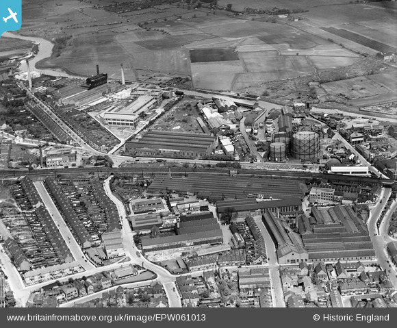
EPW061013 ENGLAND (1939). J. and E. Hall Ltd Engineering Works, Dartford, 1939
© Copyright OpenStreetMap contributors and licensed by the OpenStreetMap Foundation. 2026. Cartography is licensed as CC BY-SA.
Nearby Images (16)
Details
| Title | [EPW061013] J. and E. Hall Ltd Engineering Works, Dartford, 1939 |
| Reference | EPW061013 |
| Date | 22-May-1939 |
| Link | |
| Place name | DARTFORD |
| Parish | |
| District | |
| Country | ENGLAND |
| Easting / Northing | 554016, 174610 |
| Longitude / Latitude | 0.21670687875134, 51.449011874307 |
| National Grid Reference | TQ540746 |
Pins
Be the first to add a comment to this image!


![[EPW061013] J. and E. Hall Ltd Engineering Works, Dartford, 1939](http://britainfromabove.org.uk/sites/all/libraries/aerofilms-images/public/100x100/EPW/061/EPW061013.jpg)
![[EPW061015] J. and E. Hall Ltd Engineering Works, Dartford, 1939](http://britainfromabove.org.uk/sites/all/libraries/aerofilms-images/public/100x100/EPW/061/EPW061015.jpg)
![[EPW061006] The town, Dartford, 1939](http://britainfromabove.org.uk/sites/all/libraries/aerofilms-images/public/100x100/EPW/061/EPW061006.jpg)
![[EPW061011] The town, Dartford, 1939](http://britainfromabove.org.uk/sites/all/libraries/aerofilms-images/public/100x100/EPW/061/EPW061011.jpg)
![[EPW021982] J & E Hall Engineering Works, Dartford, 1928. This image has been produced from a print.](http://britainfromabove.org.uk/sites/all/libraries/aerofilms-images/public/100x100/EPW/021/EPW021982.jpg)
![[EPW021979] J & E Hall Engineering Works, Dartford, 1928](http://britainfromabove.org.uk/sites/all/libraries/aerofilms-images/public/100x100/EPW/021/EPW021979.jpg)
![[EPW021980] J & E Hall Engineering Works and environs, Dartford, 1928. This image has been produced from a print.](http://britainfromabove.org.uk/sites/all/libraries/aerofilms-images/public/100x100/EPW/021/EPW021980.jpg)
![[EPW061012] Kent Road and environs, Dartford, 1939](http://britainfromabove.org.uk/sites/all/libraries/aerofilms-images/public/100x100/EPW/061/EPW061012.jpg)
![[EPW010894] The Gas Works and surroundings, Dartford, 1924](http://britainfromabove.org.uk/sites/all/libraries/aerofilms-images/public/100x100/EPW/010/EPW010894.jpg)
![[EPW021977] J & E Hall Engineering Works, Dartford, 1928](http://britainfromabove.org.uk/sites/all/libraries/aerofilms-images/public/100x100/EPW/021/EPW021977.jpg)
![[EPR000367] The Greaseproof Paper Mills Ltd and Dartford Paper Mills Ltd Works off Priory Road, Dartford, 1934. This image was marked by Aero Pictorial Ltd for photo editing.](http://britainfromabove.org.uk/sites/all/libraries/aerofilms-images/public/100x100/EPR/000/EPR000367.jpg)
![[EPW010895] Hall's Engineering Works and surroundings, Dartford, 1924](http://britainfromabove.org.uk/sites/all/libraries/aerofilms-images/public/100x100/EPW/010/EPW010895.jpg)
![[EAW013644] Wiggins, Teape and Co Paper Mills, Dartford, 1948. This image was marked by Aerofilms Ltd for photo editing.](http://britainfromabove.org.uk/sites/all/libraries/aerofilms-images/public/100x100/EAW/013/EAW013644.jpg)
![[EPW061007] The town, Dartford, 1939](http://britainfromabove.org.uk/sites/all/libraries/aerofilms-images/public/100x100/EPW/061/EPW061007.jpg)
![[EAW013652] Wiggins, Teape and Co Paper Mills, Dartford, 1948](http://britainfromabove.org.uk/sites/all/libraries/aerofilms-images/public/100x100/EAW/013/EAW013652.jpg)
![[EPW061008] The town, Dartford, 1939](http://britainfromabove.org.uk/sites/all/libraries/aerofilms-images/public/100x100/EPW/061/EPW061008.jpg)