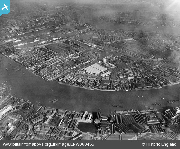
EPW060455 ENGLAND (1939). The West India and Millwall Docks and the surrounding industrial area, Isle of Dogs, 1939
© Copyright OpenStreetMap contributors and licensed by the OpenStreetMap Foundation. 2026. Cartography is licensed as CC BY-SA.
Nearby Images (25)
Details
| Title | [EPW060455] The West India and Millwall Docks and the surrounding industrial area, Isle of Dogs, 1939 |
| Reference | EPW060455 |
| Date | 7-February-1939 |
| Link | |
| Place name | ISLE OF DOGS |
| Parish | |
| District | |
| Country | ENGLAND |
| Easting / Northing | 537393, 178949 |
| Longitude / Latitude | -0.02069313289031, 51.49228542025 |
| National Grid Reference | TQ374789 |
Pins

Grollo |
Thursday 6th of March 2014 11:22:32 PM | |

Grollo |
Thursday 6th of March 2014 11:20:12 PM | |
The previous comment by myself is incorrect. Dunbar House was completed in 1932 |

Grollo |
Tuesday 25th of March 2014 07:21:40 PM |

moses72 |
Saturday 31st of August 2013 02:32:36 PM | |

moses72 |
Saturday 31st of August 2013 02:30:33 PM | |

moses72 |
Saturday 31st of August 2013 02:29:35 PM |


![[EPW060455] The West India and Millwall Docks and the surrounding industrial area, Isle of Dogs, 1939](http://britainfromabove.org.uk/sites/all/libraries/aerofilms-images/public/100x100/EPW/060/EPW060455.jpg)
![[EAW011754] McDougalls Limited Wheatsheaf Flour Mills and environs, Millwall, 1947](http://britainfromabove.org.uk/sites/all/libraries/aerofilms-images/public/100x100/EAW/011/EAW011754.jpg)
![[EPW044130] West India Docks, Millwall Docks and environs, Isle of Dogs, from the south-west, 1934](http://britainfromabove.org.uk/sites/all/libraries/aerofilms-images/public/100x100/EPW/044/EPW044130.jpg)
![[EPW046149] The Telegraph and India Rubber Works and environs, Isle of Dogs, from the west, 1934](http://britainfromabove.org.uk/sites/all/libraries/aerofilms-images/public/100x100/EPW/046/EPW046149.jpg)
![[EAW011759] McDougalls Limited Wheatsheaf Flour Mills, Millwall, 1947](http://britainfromabove.org.uk/sites/all/libraries/aerofilms-images/public/100x100/EAW/011/EAW011759.jpg)
![[EPW046145] Millwall Docks and environs, Isle of Dogs, from the north, 1934](http://britainfromabove.org.uk/sites/all/libraries/aerofilms-images/public/100x100/EPW/046/EPW046145.jpg)
![[EPW046147] Millwall Docks, Cubitt Town and environs, Isle of Dogs, from the north-west, 1934](http://britainfromabove.org.uk/sites/all/libraries/aerofilms-images/public/100x100/EPW/046/EPW046147.jpg)
![[EPW046146] Millwall Docks and environs, Isle of Dogs, from the north, 1934](http://britainfromabove.org.uk/sites/all/libraries/aerofilms-images/public/100x100/EPW/046/EPW046146.jpg)
![[EAW011755] McDougalls Limited Wheatsheaf Flour Mills, Millwall, 1947](http://britainfromabove.org.uk/sites/all/libraries/aerofilms-images/public/100x100/EAW/011/EAW011755.jpg)
![[EAW011758] McDougalls Limited Wheatsheaf Flour Mills, Millwall, 1947](http://britainfromabove.org.uk/sites/all/libraries/aerofilms-images/public/100x100/EAW/011/EAW011758.jpg)
![[EAW011757] McDougalls Limited Wheatsheaf Flour Mills and Millwall Outer Dock, Millwall, 1947](http://britainfromabove.org.uk/sites/all/libraries/aerofilms-images/public/100x100/EAW/011/EAW011757.jpg)
![[EAW011756] McDougalls Limited Wheatsheaf Flour Mills, Millwall, 1947](http://britainfromabove.org.uk/sites/all/libraries/aerofilms-images/public/100x100/EAW/011/EAW011756.jpg)
![[EPW060548] Millwall Outer Dock, Millwall, 1939](http://britainfromabove.org.uk/sites/all/libraries/aerofilms-images/public/100x100/EPW/060/EPW060548.jpg)
![[EPW044131] West India Docks, Millwall Docks and environs, Isle of Dogs, from the south, 1934](http://britainfromabove.org.uk/sites/all/libraries/aerofilms-images/public/100x100/EPW/044/EPW044131.jpg)
![[EAW011752] McDougalls Limited Wheatsheaf Flour Mills, Millwall, 1947](http://britainfromabove.org.uk/sites/all/libraries/aerofilms-images/public/100x100/EAW/011/EAW011752.jpg)
![[EAW011753] McDougalls Limited Wheatsheaf Flour Mills, Millwall, 1947](http://britainfromabove.org.uk/sites/all/libraries/aerofilms-images/public/100x100/EAW/011/EAW011753.jpg)
![[EPW016690] Edward Le Bas and Co Cyclops Iron Works, Millwall, 1926](http://britainfromabove.org.uk/sites/all/libraries/aerofilms-images/public/100x100/EPW/016/EPW016690.jpg)
![[EPW016692] Edward Le Bas Cyclops Iron Works and environs, Millwall, 1926](http://britainfromabove.org.uk/sites/all/libraries/aerofilms-images/public/100x100/EPW/016/EPW016692.jpg)
![[EAW045666] Winkley's Wharf, Isle of Dogs, 1952. This image was marked by Aerofilms Ltd for photo editing.](http://britainfromabove.org.uk/sites/all/libraries/aerofilms-images/public/100x100/EAW/045/EAW045666.jpg)
![[EPW016688] Edward Le Bas and Co Cyclops Iron Works, Millwall, 1926](http://britainfromabove.org.uk/sites/all/libraries/aerofilms-images/public/100x100/EPW/016/EPW016688.jpg)
![[EAW045667] Winkley's Wharf, Isle of Dogs, 1952. This image was marked by Aerofilms Ltd for photo editing.](http://britainfromabove.org.uk/sites/all/libraries/aerofilms-images/public/100x100/EAW/045/EAW045667.jpg)
![[EAW045670] Winkley's Wharf, Isle of Dogs, 1952. This image was marked by Aerofilms Ltd for photo editing.](http://britainfromabove.org.uk/sites/all/libraries/aerofilms-images/public/100x100/EAW/045/EAW045670.jpg)
![[EAW045672] Winkley's Wharf, Isle of Dogs, 1952. This image was marked by Aerofilms Ltd for photo editing.](http://britainfromabove.org.uk/sites/all/libraries/aerofilms-images/public/100x100/EAW/045/EAW045672.jpg)
![[EPW015764] The River Thames at Winkley's Wharf and Victoria Wharf, Millwall, 1926. This image has been produced from a print.](http://britainfromabove.org.uk/sites/all/libraries/aerofilms-images/public/100x100/EPW/015/EPW015764.jpg)
![[EPW016687] Edward Le Bas and Co Cyclops Iron Works, Millwall, 1926](http://britainfromabove.org.uk/sites/all/libraries/aerofilms-images/public/100x100/EPW/016/EPW016687.jpg)