
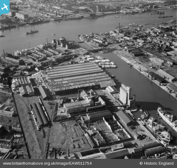
EAW011754 ENGLAND (1947). McDougalls Limited Wheatsheaf Flour Mills and environs, Millwall, 1947
© Copyright OpenStreetMap contributors and licensed by the OpenStreetMap Foundation. 2026. Cartography is licensed as CC BY-SA.
Nearby Images (18)
EAW011754

EPW060455

EPW044130

EAW011759

EPW046149

EPW046147

EPW046146

EPW046145

EAW011755

EAW011757

EPW060548

EAW011758

EAW011756

EAW011753

EPW044131

EAW011752

EPW016690

EPW016688

Details
| Title | [EAW011754] McDougalls Limited Wheatsheaf Flour Mills and environs, Millwall, 1947 |
| Reference | EAW011754 |
| Date | 9-October-1947 |
| Link | |
| Place name | MILLWALL |
| Parish | |
| District | |
| Country | ENGLAND |
| Easting / Northing | 537436, 178956 |
| Longitude / Latitude | -0.02007133906414, 51.492337877771 |
| National Grid Reference | TQ374790 |
Pins

Baz 1969 |
Tuesday 29th of December 2020 01:01:03 PM | |

Sparky |
Sunday 10th of September 2017 11:30:49 PM | |
|
John W |
Saturday 17th of September 2016 07:32:31 PM | |
|
MB |
Saturday 17th of September 2016 04:22:12 PM | |
Possible - there were flour mills along Deptford Creek, not so far away, which could only receive grain by barges due to the limitations on the size of boats that could use the Creek. |
John W |
Saturday 17th of September 2016 07:29:11 PM |
|
MB |
Saturday 17th of September 2016 04:20:50 PM | |

Class31 |
Saturday 2nd of March 2013 08:11:45 PM | |
|
Class31 |
Saturday 2nd of March 2013 08:10:00 PM | |
|
PeterJames |
Sunday 11th of November 2012 12:40:12 AM | |
|
PeterJames |
Sunday 11th of November 2012 12:35:08 AM |