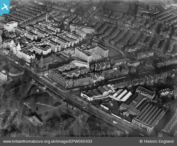
EPW060433 ENGLAND (1939). St Mary's Hospital and Manchester Royal Infirmary, Manchester, 1939
© Copyright OpenStreetMap contributors and licensed by the OpenStreetMap Foundation. 2026. Cartography is licensed as CC BY-SA.
Nearby Images (16)
Details
| Title | [EPW060433] St Mary's Hospital and Manchester Royal Infirmary, Manchester, 1939 |
| Reference | EPW060433 |
| Date | 6-February-1939 |
| Link | |
| Place name | MANCHESTER |
| Parish | |
| District | |
| Country | ENGLAND |
| Easting / Northing | 385084, 395920 |
| Longitude / Latitude | -2.224675235265, 53.45956361104 |
| National Grid Reference | SJ851959 |
Pins
Be the first to add a comment to this image!


![[EPW060433] St Mary's Hospital and Manchester Royal Infirmary, Manchester, 1939](http://britainfromabove.org.uk/sites/all/libraries/aerofilms-images/public/100x100/EPW/060/EPW060433.jpg)
![[EPW060426] St Mary's Hospital and Manchester Royal Infirmary, Manchester, 1939](http://britainfromabove.org.uk/sites/all/libraries/aerofilms-images/public/100x100/EPW/060/EPW060426.jpg)
![[EPW060432] St Mary's Hospital, Manchester, 1939](http://britainfromabove.org.uk/sites/all/libraries/aerofilms-images/public/100x100/EPW/060/EPW060432.jpg)
![[EPW060427] St Mary's Hospital and Manchester Royal Infirmary, Manchester, 1939](http://britainfromabove.org.uk/sites/all/libraries/aerofilms-images/public/100x100/EPW/060/EPW060427.jpg)
![[EPW060431] St Mary's Hospital, Manchester, 1939](http://britainfromabove.org.uk/sites/all/libraries/aerofilms-images/public/100x100/EPW/060/EPW060431.jpg)
![[EPW060425] St Mary's Hospital and Manchester Royal Infirmary, Manchester, 1939](http://britainfromabove.org.uk/sites/all/libraries/aerofilms-images/public/100x100/EPW/060/EPW060425.jpg)
![[EPW060429] St Mary's Hospital and Manchester Royal Infirmary, Manchester, 1939](http://britainfromabove.org.uk/sites/all/libraries/aerofilms-images/public/100x100/EPW/060/EPW060429.jpg)
![[EPW060423] St Mary's Hospital, Manchester, 1939](http://britainfromabove.org.uk/sites/all/libraries/aerofilms-images/public/100x100/EPW/060/EPW060423.jpg)
![[EPW060430] St Mary's Hospital, Manchester, 1939](http://britainfromabove.org.uk/sites/all/libraries/aerofilms-images/public/100x100/EPW/060/EPW060430.jpg)
![[EPW060424] St Mary's Hospital, Manchester, 1939](http://britainfromabove.org.uk/sites/all/libraries/aerofilms-images/public/100x100/EPW/060/EPW060424.jpg)
![[EPW060428] St Mary's Hospital and Whitworth Park, Manchester, 1939](http://britainfromabove.org.uk/sites/all/libraries/aerofilms-images/public/100x100/EPW/060/EPW060428.jpg)
![[EPW017615] The Royal Infirmary, Manchester, 1927](http://britainfromabove.org.uk/sites/all/libraries/aerofilms-images/public/100x100/EPW/017/EPW017615.jpg)
![[EPW016726] The Royal Infirmary and Whitworth Park, Manchester, 1926](http://britainfromabove.org.uk/sites/all/libraries/aerofilms-images/public/100x100/EPW/016/EPW016726.jpg)
![[EPW019134] Manchester Royal Infirmary, Manchester, 1927](http://britainfromabove.org.uk/sites/all/libraries/aerofilms-images/public/100x100/EPW/019/EPW019134.jpg)
![[EPW016725] The Royal Infirmary, Manchester, 1926](http://britainfromabove.org.uk/sites/all/libraries/aerofilms-images/public/100x100/EPW/016/EPW016725.jpg)
![[EPW055072] Manchester Royal Infirmary, Whitworth Park and the city, Manchester, 1937](http://britainfromabove.org.uk/sites/all/libraries/aerofilms-images/public/100x100/EPW/055/EPW055072.jpg)