
EPW019134 ENGLAND (1927). Manchester Royal Infirmary, Manchester, 1927

© Copyright OpenStreetMap contributors and licensed by the OpenStreetMap Foundation. 2026. Cartography is licensed as CC BY-SA.
Nearby Images (17)
EPW019134

EPW016725

EPW016726

EPW017615

EPW017522

EPW055072

EPW060424

EPW060430

EPW060432

EPW060431

EPW060426

EPW060433

EPW060428

EPW060423

EPW060429

EPW060427

EPW060425

Details
| Title | [EPW019134] Manchester Royal Infirmary, Manchester, 1927 |
| Reference | EPW019134 |
| Date | 5-August-1927 |
| Link | |
| Place name | MANCHESTER |
| Parish | |
| District | |
| Country | ENGLAND |
| Easting / Northing | 385003, 396083 |
| Longitude / Latitude | -2.225903081174, 53.461026591358 |
| National Grid Reference | SJ850961 |
Pins

Hutch |
Monday 29th of June 2020 06:00:06 PM | |
|
hoppy |
Sunday 23rd of December 2012 01:14:02 AM | |
|
hoppy |
Sunday 23rd of December 2012 01:12:40 AM | |
|
hoppy |
Sunday 23rd of December 2012 01:11:13 AM | |
|
hoppy |
Sunday 23rd of December 2012 01:10:05 AM | |
|
hoppy |
Sunday 23rd of December 2012 01:08:18 AM | |
|
hoppy |
Sunday 23rd of December 2012 01:04:50 AM | |
|
hoppy |
Sunday 23rd of December 2012 01:03:45 AM | |
|
hoppy |
Sunday 23rd of December 2012 01:02:45 AM | |
|
hoppy |
Sunday 23rd of December 2012 01:01:57 AM | |
|
hoppy |
Sunday 23rd of December 2012 01:01:01 AM | |
|
hoppy |
Sunday 23rd of December 2012 12:57:48 AM | |
|
hoppy |
Sunday 23rd of December 2012 12:56:20 AM | |
|
hoppy |
Sunday 23rd of December 2012 12:53:13 AM | |
|
TheBlueCube |
Monday 19th of November 2012 01:31:12 AM | |
|
TheBlueCube |
Monday 19th of November 2012 01:30:39 AM |
User Comment Contributions
The street immediately behind the rear of the Infirmary linking it to Upper brook St was Lorne St. We lived in the last house at no 14. The space to the right on Upper brook St itself was Holberry's Garage and funeral directors and the buildings were where they made the coffins. The Holberrys were friends of my parents |
lamplighter |
Thursday 15th of September 2016 04:05:17 PM |
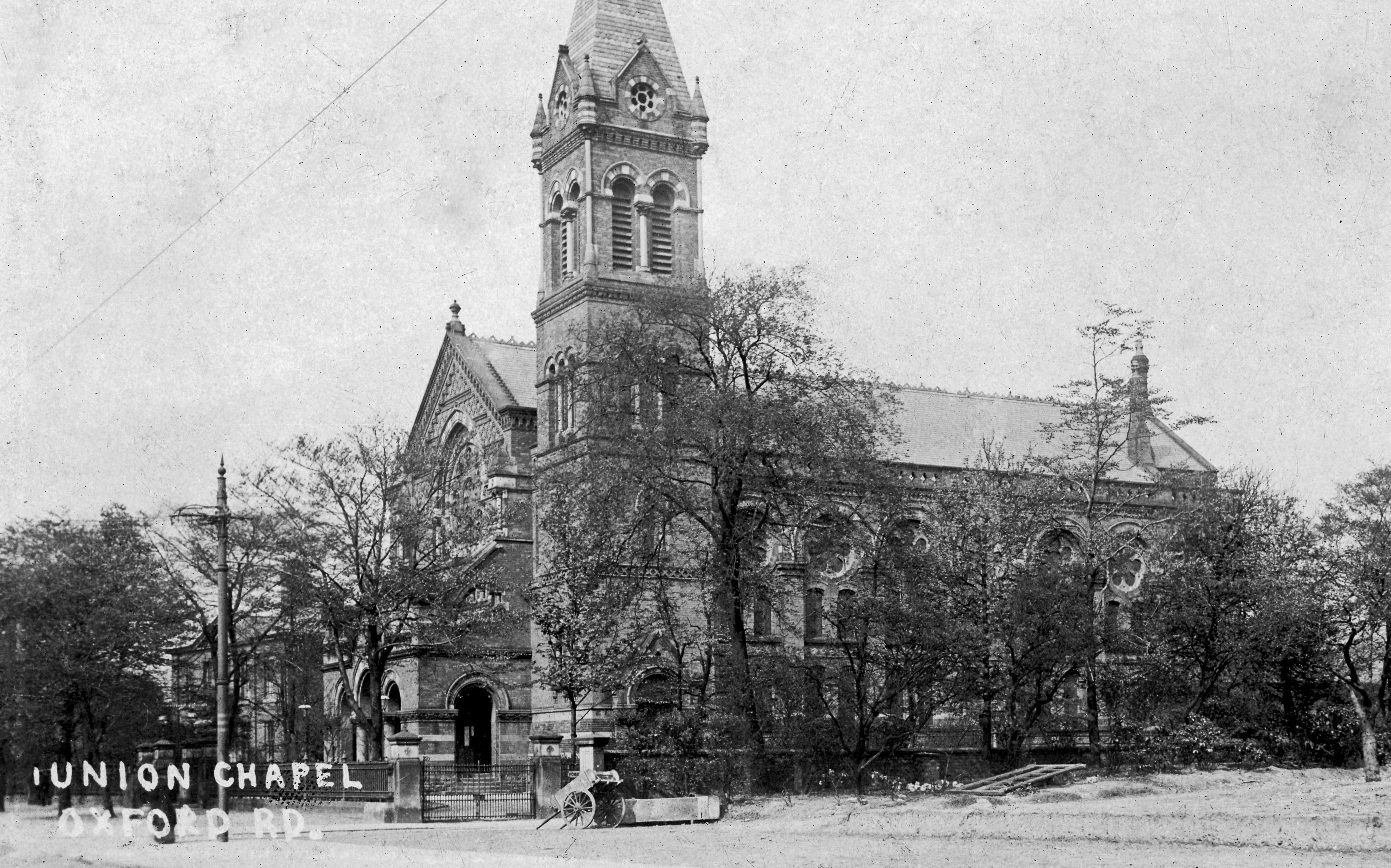
The original two towers of the Infirmary can be seen here before one was destroyed in WW11. Next to the hospital on the right is Union Chapel, it was erected in 1869 and was sometimes referred to as the ''Nonconformist Cathedral of Lancashire'. The Rev. Alexander McLaren served in Manchester at the Union Chapel, Oxford Road for a total of 45 years, from 1858 until 1903, he was considered one of the most important preachers in the country. The Sunday and mid-week sermons by the Rev McLaren drew a packed and influential congregation including bankers, merchants, and manufacturers, MPs, writers, artists, students and fellow ministers, artisans, and clerks. The last service was in 1939, the chapel being purchased by Manchester Royal Infirmary so that the hospital could be enlarged. The war delayed these plans and the Chapel was finally demolished in 1950. |
rusholmearchive |
Sunday 1st of July 2012 12:21:11 PM |