
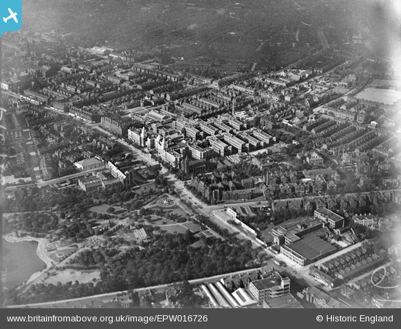
EPW016726 ENGLAND (1926). The Royal Infirmary and Whitworth Park, Manchester, 1926
© Copyright OpenStreetMap contributors and licensed by the OpenStreetMap Foundation. 2026. Cartography is licensed as CC BY-SA.
Nearby Images (17)
EPW016726

EPW017615

EPW019134

EPW016725

EPW060424

EPW060430

EPW060432

EPW060426

EPW060431

EPW060433

EPW060428

EPW060429

EPW060423

EPW060427

EPW060425

EPW017522

EPW055072

Details
| Title | [EPW016726] The Royal Infirmary and Whitworth Park, Manchester, 1926 |
| Reference | EPW016726 |
| Date | August-1926 |
| Link | |
| Place name | MANCHESTER |
| Parish | |
| District | |
| Country | ENGLAND |
| Easting / Northing | 385018, 396008 |
| Longitude / Latitude | -2.2256735596824, 53.460352809466 |
| National Grid Reference | SJ850960 |
Pins

Bottom Yard |
Sunday 3rd of March 2019 02:45:03 PM | |
|
Bottom Yard |
Sunday 3rd of March 2019 02:43:59 PM | |
|
Bottom Yard |
Sunday 3rd of March 2019 02:43:12 PM | |
|
Stevieblue52 |
Sunday 23rd of July 2017 06:19:23 PM | |
|
Stevieblue52 |
Wednesday 10th of June 2015 04:21:34 AM | |
|
hoppy |
Sunday 23rd of December 2012 07:08:51 AM | |
|
hoppy |
Sunday 23rd of December 2012 07:07:13 AM | |
|
hoppy |
Sunday 23rd of December 2012 07:04:59 AM | |
|
hoppy |
Sunday 23rd of December 2012 07:03:42 AM | |
|
hoppy |
Sunday 23rd of December 2012 07:02:15 AM | |
|
hoppy |
Sunday 23rd of December 2012 06:59:28 AM | |
|
hoppy |
Sunday 23rd of December 2012 06:58:05 AM |
