
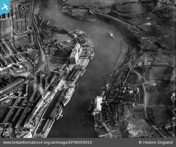
EPW059919 ENGLAND (1938). The Tyne Flour Mill, the River Tyne and the Quayside, Newcastle Upon Tyne, 1938
© Copyright OpenStreetMap contributors and licensed by the OpenStreetMap Foundation. 2026. Cartography is licensed as CC BY-SA.
Nearby Images (13)
EPW059919

EPW059921

EAW037003
 moored on the River Tyne opposite the South Shore Road Engineering Works, Byker, 1951. This image has been produced from a print.")
EAW037005
 moored on the River Tyne near the Tyne Mill, Byker, 1951. This image has been produced from a print.")
EAW037007
 moored on the River Tyne and the area around St Lawrence Park, Byker, 1951. This image has been produced from a print.")
EAW037006
 moored on the River Tyne, Byker, 1951. This image has been produced from a print.")
EAW037004
 moored on the River Tyne near the Tyne Mill, Byker, 1951. This image has been produced from a print.")
EPW062213

EPW062212

EPW059924

EPW059920

EPW059923

EPW059922

Details
| Title | [EPW059919] The Tyne Flour Mill, the River Tyne and the Quayside, Newcastle Upon Tyne, 1938 |
| Reference | EPW059919 |
| Date | 11-October-1938 |
| Link | |
| Place name | NEWCASTLE UPON TYNE |
| Parish | |
| District | |
| Country | ENGLAND |
| Easting / Northing | 426787, 563722 |
| Longitude / Latitude | -1.5815454572535, 54.96732498241 |
| National Grid Reference | NZ268637 |
Pins

James Fenwick |
Tuesday 27th of August 2024 09:14:02 AM | |
|
James Fenwick |
Tuesday 27th of August 2024 09:13:37 AM | |

Dylan Moore |
Saturday 9th of December 2017 10:40:29 AM | |
|
Dylan Moore |
Saturday 9th of December 2017 10:37:57 AM | |
|
Dylan Moore |
Saturday 9th of December 2017 10:36:34 AM | |
|
Dylan Moore |
Saturday 9th of December 2017 10:34:16 AM | |
|
Dylan Moore |
Saturday 9th of December 2017 10:32:31 AM | |
|
MB |
Friday 16th of September 2016 09:35:41 PM | |
|
MB |
Friday 16th of September 2016 09:34:39 PM | |
|
Kenny |
Thursday 1st of May 2014 06:32:10 PM | |
|
Kenny |
Thursday 1st of May 2014 06:30:41 PM | |
|
Kenny |
Thursday 1st of May 2014 06:29:09 PM | |
|
Kenny |
Thursday 1st of May 2014 06:20:45 PM |