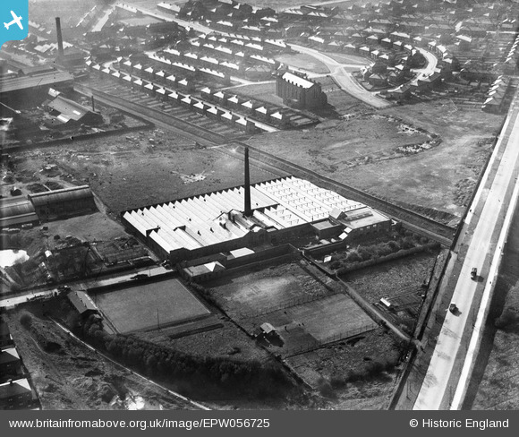
EPW056725 ENGLAND (1938). The Emerson Cotton Mill, Ribbleton, 1938
© Copyright OpenStreetMap contributors and licensed by the OpenStreetMap Foundation. 2026. Cartography is licensed as CC BY-SA.
Nearby Images (29)
Details
| Title | [EPW056725] The Emerson Cotton Mill, Ribbleton, 1938 |
| Reference | EPW056725 |
| Date | 6-April-1938 |
| Link | |
| Place name | RIBBLETON |
| Parish | |
| District | |
| Country | ENGLAND |
| Easting / Northing | 355471, 430723 |
| Longitude / Latitude | -2.6756811448724, 53.770725076233 |
| National Grid Reference | SD555307 |
Pins

totoro |
Wednesday 19th of March 2014 01:04:56 PM | |

totoro |
Wednesday 19th of March 2014 01:03:45 PM | |

totoro |
Wednesday 19th of March 2014 01:02:07 PM | |

totoro |
Wednesday 19th of March 2014 12:46:59 PM | |

totoro |
Wednesday 19th of March 2014 12:46:42 PM | |

totoro |
Wednesday 19th of March 2014 12:46:26 PM |


![[EPW056725] The Emerson Cotton Mill, Ribbleton, 1938](http://britainfromabove.org.uk/sites/all/libraries/aerofilms-images/public/100x100/EPW/056/EPW056725.jpg)
![[EPW056723] The Emerson Cotton Mill, Ribbleton, 1938](http://britainfromabove.org.uk/sites/all/libraries/aerofilms-images/public/100x100/EPW/056/EPW056723.jpg)
![[EPW056724] The Emerson Cotton Mill, Ribbleton, 1938](http://britainfromabove.org.uk/sites/all/libraries/aerofilms-images/public/100x100/EPW/056/EPW056724.jpg)
![[EPW056721] The Emerson Cotton Mill, Ribbleton, 1938](http://britainfromabove.org.uk/sites/all/libraries/aerofilms-images/public/100x100/EPW/056/EPW056721.jpg)
![[EPW026294] The Emerson Cotton Mill and Ribbleton Brick Works, Preston, 1929](http://britainfromabove.org.uk/sites/all/libraries/aerofilms-images/public/100x100/EPW/026/EPW026294.jpg)
![[EPW056722] The Emerson Cotton Mill, Ribbleton, 1938](http://britainfromabove.org.uk/sites/all/libraries/aerofilms-images/public/100x100/EPW/056/EPW056722.jpg)
![[EPW056720] The Emerson Cotton Mill, Ribbleton, 1938](http://britainfromabove.org.uk/sites/all/libraries/aerofilms-images/public/100x100/EPW/056/EPW056720.jpg)
![[EAW025997] Emerson Mill, Preston, 1949. This image has been produced from a print marked by Aerofilms Ltd for photo editing.](http://britainfromabove.org.uk/sites/all/libraries/aerofilms-images/public/100x100/EAW/025/EAW025997.jpg)
![[EAW025994] Emerson Mill, Blackpool Road and environs, Preston, 1949. This image has been produced from a print marked by Aerofilms Ltd for photo editing.](http://britainfromabove.org.uk/sites/all/libraries/aerofilms-images/public/100x100/EAW/025/EAW025994.jpg)
![[EPW026292] The Emerson Cotton Mill, Preston, 1929](http://britainfromabove.org.uk/sites/all/libraries/aerofilms-images/public/100x100/EPW/026/EPW026292.jpg)
![[EPW026295] The Emerson Cotton Mill, Preston, 1929](http://britainfromabove.org.uk/sites/all/libraries/aerofilms-images/public/100x100/EPW/026/EPW026295.jpg)
![[EPW026291] The Emerson Cotton Mill, Preston, 1929](http://britainfromabove.org.uk/sites/all/libraries/aerofilms-images/public/100x100/EPW/026/EPW026291.jpg)
![[EPW026296] The Emerson Cotton Mill, Preston, 1929](http://britainfromabove.org.uk/sites/all/libraries/aerofilms-images/public/100x100/EPW/026/EPW026296.jpg)
![[EPW026293] The Emerson Cotton Mill, Preston, 1929](http://britainfromabove.org.uk/sites/all/libraries/aerofilms-images/public/100x100/EPW/026/EPW026293.jpg)
![[EPW026399] Emerson Cotton Mill and environs, Preston, 1929. Double-exposed negative.](http://britainfromabove.org.uk/sites/all/libraries/aerofilms-images/public/100x100/EPW/026/EPW026399.jpg)
![[EAW025999] Emerson Mill and environs, Preston, 1949. This image has been produced from a print marked by Aerofilms Ltd for photo editing.](http://britainfromabove.org.uk/sites/all/libraries/aerofilms-images/public/100x100/EAW/025/EAW025999.jpg)
![[EPW038861] Thomas Blackburn and Sons Ltd and environs, Preston, from the south-east, 1932. This image has been produced from a damaged negative.](http://britainfromabove.org.uk/sites/all/libraries/aerofilms-images/public/100x100/EPW/038/EPW038861.jpg)
![[EAW025996] Emerson Mill and environs, Preston, from the north-east, 1949. This image has been produced from a print marked by Aerofilms Ltd for photo editing.](http://britainfromabove.org.uk/sites/all/libraries/aerofilms-images/public/100x100/EAW/025/EAW025996.jpg)
![[EAW025993] Emerson Mill, Blackpool Road and environs, Preston, from the east, 1949. This image has been produced from a print marked by Aerofilms Ltd for photo editing.](http://britainfromabove.org.uk/sites/all/libraries/aerofilms-images/public/100x100/EAW/025/EAW025993.jpg)
![[EAW025995] Emerson Mill and environs, Preston, 1949. This image has been produced from a print marked by Aerofilms Ltd for photo editing.](http://britainfromabove.org.uk/sites/all/libraries/aerofilms-images/public/100x100/EAW/025/EAW025995.jpg)
![[EAW025998] Emerson Mill and environs, Preston, 1949. This image has been produced from a print marked by Aerofilms Ltd for photo editing.](http://britainfromabove.org.uk/sites/all/libraries/aerofilms-images/public/100x100/EAW/025/EAW025998.jpg)
![[EPW038860] Thomas Blackburn and Sons Ltd and environs, Preston, from the south-east, 1932. This image has been produced from a damaged negative.](http://britainfromabove.org.uk/sites/all/libraries/aerofilms-images/public/100x100/EPW/038/EPW038860.jpg)
![[EPW038859] Thomas Blackburn and Sons Ltd, Preston, 1932. This image has been produced from a damaged negative.](http://britainfromabove.org.uk/sites/all/libraries/aerofilms-images/public/100x100/EPW/038/EPW038859.jpg)
![[EPW038858] Thomas Blackburn and Sons Ltd, Preston, 1932. This image has been produced from a damaged negative.](http://britainfromabove.org.uk/sites/all/libraries/aerofilms-images/public/100x100/EPW/038/EPW038858.jpg)
![[EPW038866] Thomas Blackburn and Sons Ltd and environs, Preston, 1932. This image has been produced from a damaged negative.](http://britainfromabove.org.uk/sites/all/libraries/aerofilms-images/public/100x100/EPW/038/EPW038866.jpg)
![[EPW038863] Thomas Blackburn and Sons Ltd and environs, Preston, 1932](http://britainfromabove.org.uk/sites/all/libraries/aerofilms-images/public/100x100/EPW/038/EPW038863.jpg)
![[EPW038862] Thomas Blackburn and Sons Ltd, Preston, 1932. This image has been produced from a damaged negative.](http://britainfromabove.org.uk/sites/all/libraries/aerofilms-images/public/100x100/EPW/038/EPW038862.jpg)
![[EPW038864] Thomas Blackburn and Sons Ltd and environs, Preston, 1932](http://britainfromabove.org.uk/sites/all/libraries/aerofilms-images/public/100x100/EPW/038/EPW038864.jpg)
![[EPW038865] Thomas Blackburn and Sons Ltd and environs, Preston, 1932. This image has been produced from a damaged negative.](http://britainfromabove.org.uk/sites/all/libraries/aerofilms-images/public/100x100/EPW/038/EPW038865.jpg)