
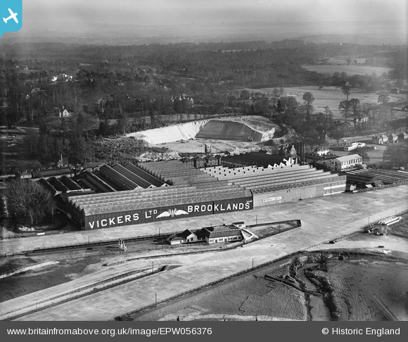
EPW056376 ENGLAND (1938). Vickers (Aviation) Ltd Works, Brooklands, from the north-west, 1938
© Copyright OpenStreetMap contributors and licensed by the OpenStreetMap Foundation. 2026. Cartography is licensed as CC BY-SA.
Nearby Images (22)
EPW056376
 Ltd Works, Brooklands, from the north-west, 1938")
EPW060342

EPW060347

EPW060345

EPW060344

EPW060343

EPW056377
 Ltd Works, Brooklands, 1938")
EPW060349

EPW056374
 Ltd Works, Brooklands, 1938")
EPW028332

EPW060346

EPW016860

EPW060350

EPW056378
 Ltd Works, Brooklands, 1938")
EPW056380
 Ltd Works, Brooklands, 1938. This image has been produced from a copy-negative.")
EPW056375
 Ltd Works, Brooklands, 1938")
EPW056379
 Ltd Works, Brooklands, 1938. This image has been produced from a damaged negative.")
EPW006784

EPW006791

EPW056381
 Ltd Works, Brooklands, 1938. This image has been produced from a damaged negative.")
EPW056382
 Ltd Works, Brooklands, 1938. This image has been produced from a damaged negative.")
EPW056383
 Ltd Works, Brooklands, 1938. This image has been produced from a damaged negative.")
Details
| Title | [EPW056376] Vickers (Aviation) Ltd Works, Brooklands, from the north-west, 1938 |
| Reference | EPW056376 |
| Date | 2-March-1938 |
| Link | |
| Place name | BROOKLANDS |
| Parish | |
| District | |
| Country | ENGLAND |
| Easting / Northing | 507069, 162324 |
| Longitude / Latitude | -0.46237616849064, 51.349394800991 |
| National Grid Reference | TQ071623 |
Pins
Be the first to add a comment to this image!