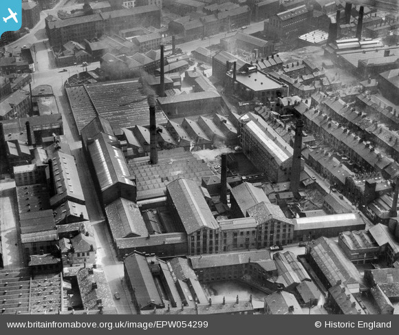
EPW054299 ENGLAND (1937). The Atlas Wool Combing Mills, Bradford, 1937
© Copyright OpenStreetMap contributors and licensed by the OpenStreetMap Foundation. 2026. Cartography is licensed as CC BY-SA.
Nearby Images (10)
Details
| Title | [EPW054299] The Atlas Wool Combing Mills, Bradford, 1937 |
| Reference | EPW054299 |
| Date | 14-July-1937 |
| Link | |
| Place name | BRADFORD |
| Parish | |
| District | |
| Country | ENGLAND |
| Easting / Northing | 415595, 433010 |
| Longitude / Latitude | -1.7632384908914, 53.79295319538 |
| National Grid Reference | SE156330 |


![[EPW054299] The Atlas Wool Combing Mills, Bradford, 1937](http://britainfromabove.org.uk/sites/all/libraries/aerofilms-images/public/100x100/EPW/054/EPW054299.jpg)
![[EPW054301] The Atlas Wool Combing Mills and surrounding streets, Bradford, 1937](http://britainfromabove.org.uk/sites/all/libraries/aerofilms-images/public/100x100/EPW/054/EPW054301.jpg)
![[EPW054298] The Atlas Wool Combing Mills, Bradford, 1937](http://britainfromabove.org.uk/sites/all/libraries/aerofilms-images/public/100x100/EPW/054/EPW054298.jpg)
![[EPW054303] The Atlas Wool Combing Mills, Bee Hive Worsted Mills and surrounding streets, Bradford, 1937](http://britainfromabove.org.uk/sites/all/libraries/aerofilms-images/public/100x100/EPW/054/EPW054303.jpg)
![[EPW054306] The Atlas Wool Combing Mills, Bradford, 1937](http://britainfromabove.org.uk/sites/all/libraries/aerofilms-images/public/100x100/EPW/054/EPW054306.jpg)
![[EPW054302] The Atlas Wool Combing Mills and surrounding streets, Bradford, 1937](http://britainfromabove.org.uk/sites/all/libraries/aerofilms-images/public/100x100/EPW/054/EPW054302.jpg)
![[EPW054300] The Atlas Wool Combing Mills and surrounding streets, Bradford, 1937](http://britainfromabove.org.uk/sites/all/libraries/aerofilms-images/public/100x100/EPW/054/EPW054300.jpg)
![[EPW054304] The Atlas Wool Combing Mills and surrounding streets, Bradford, 1937](http://britainfromabove.org.uk/sites/all/libraries/aerofilms-images/public/100x100/EPW/054/EPW054304.jpg)
![[EPW054305] The Atlas Wool Combing Mills and surrounding streets, Bradford, 1937](http://britainfromabove.org.uk/sites/all/libraries/aerofilms-images/public/100x100/EPW/054/EPW054305.jpg)
![[EAW030797] The city centre, Bradford, 1950](http://britainfromabove.org.uk/sites/all/libraries/aerofilms-images/public/100x100/EAW/030/EAW030797.jpg)
