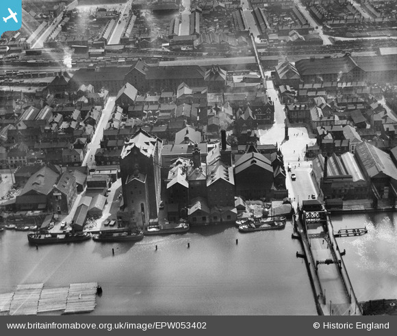
EPW053402 ENGLAND (1937). Victoria Flour Mills, Corporation Bridge and environs, Grimsby, 1937
© Copyright OpenStreetMap contributors and licensed by the OpenStreetMap Foundation. 2026. Cartography is licensed as CC BY-SA.
Nearby Images (13)
Details
| Title | [EPW053402] Victoria Flour Mills, Corporation Bridge and environs, Grimsby, 1937 |
| Reference | EPW053402 |
| Date | 31-May-1937 |
| Link | |
| Place name | GRIMSBY |
| Parish | |
| District | |
| Country | ENGLAND |
| Easting / Northing | 527122, 409989 |
| Longitude / Latitude | -0.08007206541554, 53.57083980037 |
| National Grid Reference | TA271100 |
Pins
Be the first to add a comment to this image!


![[EPW053402] Victoria Flour Mills, Corporation Bridge and environs, Grimsby, 1937](http://britainfromabove.org.uk/sites/all/libraries/aerofilms-images/public/100x100/EPW/053/EPW053402.jpg)
![[EPW053405] Victoria Flour Mills, Corporation Bridge and environs, Grimsby, 1937](http://britainfromabove.org.uk/sites/all/libraries/aerofilms-images/public/100x100/EPW/053/EPW053405.jpg)
![[EPW053406] Victoria Flour Mills, Corporation Bridge and environs, Grimsby, 1937](http://britainfromabove.org.uk/sites/all/libraries/aerofilms-images/public/100x100/EPW/053/EPW053406.jpg)
![[EPW053401] Victoria Flour Mills, Corporation Bridge and environs, Grimsby, 1937](http://britainfromabove.org.uk/sites/all/libraries/aerofilms-images/public/100x100/EPW/053/EPW053401.jpg)
![[EPW042806] The Victoria Flour Mill, Grimsby, 1933](http://britainfromabove.org.uk/sites/all/libraries/aerofilms-images/public/100x100/EPW/042/EPW042806.jpg)
![[EPW053400] Victoria Flour Mills and Corporation Bridge, Grimsby, 1937](http://britainfromabove.org.uk/sites/all/libraries/aerofilms-images/public/100x100/EPW/053/EPW053400.jpg)
![[EPW053398] Victoria Flour Mills and Corporation Bridge, Grimsby, 1937](http://britainfromabove.org.uk/sites/all/libraries/aerofilms-images/public/100x100/EPW/053/EPW053398.jpg)
![[EPW053403] The Palace Theatre, Victoria Flour Mills and environs, Grimsby, 1937](http://britainfromabove.org.uk/sites/all/libraries/aerofilms-images/public/100x100/EPW/053/EPW053403.jpg)
![[EPW012659] Alexandra Dock, Central Market and environs, Grimsby, 1925. This image has been produced from a copy-negative.](http://britainfromabove.org.uk/sites/all/libraries/aerofilms-images/public/100x100/EPW/012/EPW012659.jpg)
![[EPW053399] Victoria Flour Mills, Corporation Bridge and environs, Grimsby, 1937](http://britainfromabove.org.uk/sites/all/libraries/aerofilms-images/public/100x100/EPW/053/EPW053399.jpg)
![[EPW053404] Victoria Flour Mills, Victoria Street and environs, Grimsby, 1937](http://britainfromabove.org.uk/sites/all/libraries/aerofilms-images/public/100x100/EPW/053/EPW053404.jpg)
![[EAW029028] Alexandra Dock and the town around Grimsby Docks Railway Station, Grimsby, 1950. This image was marked by Aerofilms Ltd for photo editing.](http://britainfromabove.org.uk/sites/all/libraries/aerofilms-images/public/100x100/EAW/029/EAW029028.jpg)
![[EAW029026] The town around Grimsby Docks Railway Station, Grimsby, 1950. This image was marked by Aerofilms Ltd for photo editing.](http://britainfromabove.org.uk/sites/all/libraries/aerofilms-images/public/100x100/EAW/029/EAW029026.jpg)