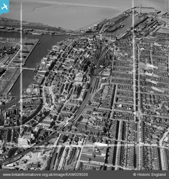
EAW029026 ENGLAND (1950). The town around Grimsby Docks Railway Station, Grimsby, 1950. This image was marked by Aerofilms Ltd for photo editing.
© Copyright OpenStreetMap contributors and licensed by the OpenStreetMap Foundation. 2026. Cartography is licensed as CC BY-SA.
Nearby Images (22)
Details
| Title | [EAW029026] The town around Grimsby Docks Railway Station, Grimsby, 1950. This image was marked by Aerofilms Ltd for photo editing. |
| Reference | EAW029026 |
| Date | 10-May-1950 |
| Link | |
| Place name | GRIMSBY |
| Parish | |
| District | |
| Country | ENGLAND |
| Easting / Northing | 527362, 409785 |
| Longitude / Latitude | -0.076532778911132, 53.568948794764 |
| National Grid Reference | TA274098 |
Pins

redmist |
Wednesday 31st of October 2018 08:11:39 PM | |

Class31 |
Wednesday 11th of May 2016 09:47:43 AM | |

Class31 |
Wednesday 15th of October 2014 05:15:52 PM | |

Class31 |
Wednesday 15th of October 2014 05:14:09 PM | |

Class31 |
Tuesday 4th of March 2014 07:14:47 PM | |

Class31 |
Tuesday 4th of March 2014 06:50:27 PM | |

Class31 |
Monday 3rd of March 2014 07:10:10 PM |
User Comment Contributions
Corporation Bridge, Grimsby, 29/08/2014 |

Class31 |
Wednesday 15th of October 2014 05:16:43 PM |


![[EAW029026] The town around Grimsby Docks Railway Station, Grimsby, 1950. This image was marked by Aerofilms Ltd for photo editing.](http://britainfromabove.org.uk/sites/all/libraries/aerofilms-images/public/100x100/EAW/029/EAW029026.jpg)
![[EAW052364] Footbridge over the railway line linking Market Street with Newmarket Street, Grimsby, 1953. This image was marked by Aerofilms Ltd for photo editing.](http://britainfromabove.org.uk/sites/all/libraries/aerofilms-images/public/100x100/EAW/052/EAW052364.jpg)
![[EPW053390] The London and North Eastern Railway Line and the West Marsh area, Grimsby, from the north-east, 1937](http://britainfromabove.org.uk/sites/all/libraries/aerofilms-images/public/100x100/EPW/053/EPW053390.jpg)
![[EAW029028] Alexandra Dock and the town around Grimsby Docks Railway Station, Grimsby, 1950. This image was marked by Aerofilms Ltd for photo editing.](http://britainfromabove.org.uk/sites/all/libraries/aerofilms-images/public/100x100/EAW/029/EAW029028.jpg)
![[EAW052057] The Osmond and Sons Ltd Railway Street Works and environs, Grimsby, 1953. This image was marked by Aerofilms Ltd for photo editing.](http://britainfromabove.org.uk/sites/all/libraries/aerofilms-images/public/100x100/EAW/052/EAW052057.jpg)
![[EAW052367] Footbridge over the railway line linking Market Street with Newmarket Street, works off Railway Street and environs, Grimsby, 1953. This image was marked by Aerofilms Ltd for photo editing.](http://britainfromabove.org.uk/sites/all/libraries/aerofilms-images/public/100x100/EAW/052/EAW052367.jpg)
![[EAW052366] Footbridge over the railway line linking Market Street with Newmarket Street and environs, Grimsby, 1953. This image was marked by Aerofilms Ltd for photo editing.](http://britainfromabove.org.uk/sites/all/libraries/aerofilms-images/public/100x100/EAW/052/EAW052366.jpg)
![[EAW052059] The Osmond and Sons Ltd Railway Street Works, Grimsby, 1953. This image was marked by Aerofilms Ltd for photo editing.](http://britainfromabove.org.uk/sites/all/libraries/aerofilms-images/public/100x100/EAW/052/EAW052059.jpg)
![[EAW052368] Footbridge over the railway line linking Market Street with Newmarket Street, Grimsby, 1953. This image was marked by Aerofilms Ltd for photo editing.](http://britainfromabove.org.uk/sites/all/libraries/aerofilms-images/public/100x100/EAW/052/EAW052368.jpg)
![[EAW052056] The Osmond and Sons Ltd Railway Street Works and environs, Grimsby, 1953. This image was marked by Aerofilms Ltd for photo editing.](http://britainfromabove.org.uk/sites/all/libraries/aerofilms-images/public/100x100/EAW/052/EAW052056.jpg)
![[EAW052365] Works off Railway Street and environs, Grimsby, 1953. This image was marked by Aerofilms Ltd for photo editing.](http://britainfromabove.org.uk/sites/all/libraries/aerofilms-images/public/100x100/EAW/052/EAW052365.jpg)
![[EAW052058] The Osmond and Sons Ltd Railway Street Works and environs, Grimsby, 1953. This image was marked by Aerofilms Ltd for photo editing.](http://britainfromabove.org.uk/sites/all/libraries/aerofilms-images/public/100x100/EAW/052/EAW052058.jpg)
![[EAW052055] The Osmond and Sons Ltd Railway Street Works, Duncombe Street and Freeman Street Market, Grimsby, 1953. This image was marked by Aerofilms Ltd for photo editing.](http://britainfromabove.org.uk/sites/all/libraries/aerofilms-images/public/100x100/EAW/052/EAW052055.jpg)
![[EPW012659] Alexandra Dock, Central Market and environs, Grimsby, 1925. This image has been produced from a copy-negative.](http://britainfromabove.org.uk/sites/all/libraries/aerofilms-images/public/100x100/EPW/012/EPW012659.jpg)
![[EPW053405] Victoria Flour Mills, Corporation Bridge and environs, Grimsby, 1937](http://britainfromabove.org.uk/sites/all/libraries/aerofilms-images/public/100x100/EPW/053/EPW053405.jpg)
![[EPW053402] Victoria Flour Mills, Corporation Bridge and environs, Grimsby, 1937](http://britainfromabove.org.uk/sites/all/libraries/aerofilms-images/public/100x100/EPW/053/EPW053402.jpg)
![[EPW053406] Victoria Flour Mills, Corporation Bridge and environs, Grimsby, 1937](http://britainfromabove.org.uk/sites/all/libraries/aerofilms-images/public/100x100/EPW/053/EPW053406.jpg)
![[EPW053401] Victoria Flour Mills, Corporation Bridge and environs, Grimsby, 1937](http://britainfromabove.org.uk/sites/all/libraries/aerofilms-images/public/100x100/EPW/053/EPW053401.jpg)
![[EPW053403] The Palace Theatre, Victoria Flour Mills and environs, Grimsby, 1937](http://britainfromabove.org.uk/sites/all/libraries/aerofilms-images/public/100x100/EPW/053/EPW053403.jpg)
![[EPW042806] The Victoria Flour Mill, Grimsby, 1933](http://britainfromabove.org.uk/sites/all/libraries/aerofilms-images/public/100x100/EPW/042/EPW042806.jpg)
![[EPW053404] Victoria Flour Mills, Victoria Street and environs, Grimsby, 1937](http://britainfromabove.org.uk/sites/all/libraries/aerofilms-images/public/100x100/EPW/053/EPW053404.jpg)
![[EPW053399] Victoria Flour Mills, Corporation Bridge and environs, Grimsby, 1937](http://britainfromabove.org.uk/sites/all/libraries/aerofilms-images/public/100x100/EPW/053/EPW053399.jpg)