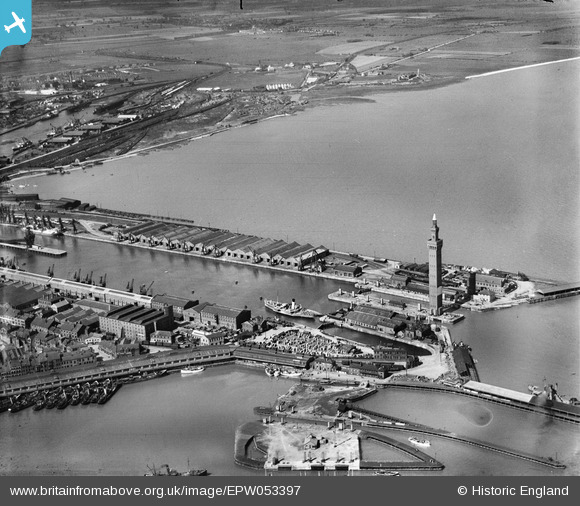
EPW053397 ENGLAND (1937). Grimsby Dock Tower and the Royal Dock, Grimsby, from the east, 1937
© Copyright OpenStreetMap contributors and licensed by the OpenStreetMap Foundation. 2026. Cartography is licensed as CC BY-SA.
Nearby Images (21)
Details
| Title | [EPW053397] Grimsby Dock Tower and the Royal Dock, Grimsby, from the east, 1937 |
| Reference | EPW053397 |
| Date | 31-May-1937 |
| Link | |
| Place name | GRIMSBY |
| Parish | |
| District | |
| Country | ENGLAND |
| Easting / Northing | 527865, 411202 |
| Longitude / Latitude | -0.068360643268288, 53.581557110889 |
| National Grid Reference | TA279112 |


![[EPW053397] Grimsby Dock Tower and the Royal Dock, Grimsby, from the east, 1937](http://britainfromabove.org.uk/sites/all/libraries/aerofilms-images/public/100x100/EPW/053/EPW053397.jpg)
![[EAW029073] The Royal Dock and Tidal Basin, Grimsby, 1950. This image was marked by Aerofilms Ltd for photo editing.](http://britainfromabove.org.uk/sites/all/libraries/aerofilms-images/public/100x100/EAW/029/EAW029073.jpg)
![[EAW029405] The Docks, Grimsby, 1950](http://britainfromabove.org.uk/sites/all/libraries/aerofilms-images/public/100x100/EAW/029/EAW029405.jpg)
![[EAW029407] The Docks, Grimsby, 1950](http://britainfromabove.org.uk/sites/all/libraries/aerofilms-images/public/100x100/EAW/029/EAW029407.jpg)
![[EAW029406] The Docks, Grimsby, 1950](http://britainfromabove.org.uk/sites/all/libraries/aerofilms-images/public/100x100/EAW/029/EAW029406.jpg)
![[EAW029071] The Royal Dock, Tidal Basin and Fish Docks, Grimsby, 1950. This image was marked by Aerofilms Ltd for photo editing.](http://britainfromabove.org.uk/sites/all/libraries/aerofilms-images/public/100x100/EAW/029/EAW029071.jpg)
![[EAW029404] The Dock Tower and No. 1 Graving Dock, Grimsby, 1950](http://britainfromabove.org.uk/sites/all/libraries/aerofilms-images/public/100x100/EAW/029/EAW029404.jpg)
![[EAW029078] The Tidal Basin, Royal Dock and Fish Docks, Grimsby, 1950. This image was marked by Aerofilms Ltd for photo editing.](http://britainfromabove.org.uk/sites/all/libraries/aerofilms-images/public/100x100/EAW/029/EAW029078.jpg)
![[EAW029016] The Royal Dock and Tidal Basin, Grimsby, 1950. This image was marked by Aerofilms Ltd for photo editing.](http://britainfromabove.org.uk/sites/all/libraries/aerofilms-images/public/100x100/EAW/029/EAW029016.jpg)
![[EAW029077] The Dock Tower, Royal Dock and Tidal Basin, Grimsby, 1950. This image was marked by Aerofilms Ltd for photo editing.](http://britainfromabove.org.uk/sites/all/libraries/aerofilms-images/public/100x100/EAW/029/EAW029077.jpg)
![[EAW029014] The Royal Dock and Tidal Basin, Grimsby, 1950. This image was marked by Aerofilms Ltd for photo editing.](http://britainfromabove.org.uk/sites/all/libraries/aerofilms-images/public/100x100/EAW/029/EAW029014.jpg)
![[EAW029068] The Royal Dock, Tidal Basin and Dock Tower, Grimsby, 1950. This image was marked by Aerofilms Ltd for photo editing.](http://britainfromabove.org.uk/sites/all/libraries/aerofilms-images/public/100x100/EAW/029/EAW029068.jpg)
![[EPW012668] The Dock Tower, Grimsby, 1925](http://britainfromabove.org.uk/sites/all/libraries/aerofilms-images/public/100x100/EPW/012/EPW012668.jpg)
![[EAW029070] The Royal Dock, Tidal Basin and Fish Docks, Grimsby, 1950. This image was marked by Aerofilms Ltd for photo editing.](http://britainfromabove.org.uk/sites/all/libraries/aerofilms-images/public/100x100/EAW/029/EAW029070.jpg)
![[EAW029075] The Dock Tower and Tidal Basin, Grimsby, 1950. This image was marked by Aerofilms Ltd for photo editing.](http://britainfromabove.org.uk/sites/all/libraries/aerofilms-images/public/100x100/EAW/029/EAW029075.jpg)
![[EPW012666] The Dock Tower, Royal and No 1 Fish Docks, Grimsby, 1925](http://britainfromabove.org.uk/sites/all/libraries/aerofilms-images/public/100x100/EPW/012/EPW012666.jpg)
![[EAW029410] The Docks, Grimsby, 1950](http://britainfromabove.org.uk/sites/all/libraries/aerofilms-images/public/100x100/EAW/029/EAW029410.jpg)
![[EAW029013] The Royal Dock and Tidal Basin, Grimsby, 1950. This image was marked by Aerofilms Ltd for photo editing.](http://britainfromabove.org.uk/sites/all/libraries/aerofilms-images/public/100x100/EAW/029/EAW029013.jpg)
![[EAW029067] The Royal Dock and Tidal Basin, Grimsby, 1950. This image was marked by Aerofilms Ltd for photo editing.](http://britainfromabove.org.uk/sites/all/libraries/aerofilms-images/public/100x100/EAW/029/EAW029067.jpg)
![[EAW029074] The Royal Dock, Tidal Basin and Fish Docks, Grimsby, 1950. This image was marked by Aerofilms Ltd for photo editing.](http://britainfromabove.org.uk/sites/all/libraries/aerofilms-images/public/100x100/EAW/029/EAW029074.jpg)
![[EAW029072] The Royal Dock and Tidal Basin, Grimsby, 1950. This image was marked by Aerofilms Ltd for photo editing.](http://britainfromabove.org.uk/sites/all/libraries/aerofilms-images/public/100x100/EAW/029/EAW029072.jpg)

