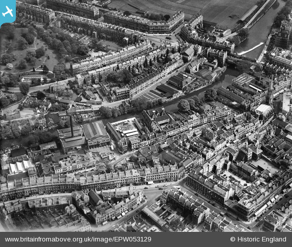
EPW053129 ENGLAND (1937). The Tramway Depot, the Cattle Market and Laura Place, Bath, 1937
    © Copyright OpenStreetMap contributors and licensed by the OpenStreetMap Foundation. 2025. Cartography is licensed as CC BY-SA.
  
Nearby Images (19)
Details
| Title | [EPW053129] The Tramway Depot, the Cattle Market and Laura Place, Bath, 1937 | 
| Reference | EPW053129 | 
| Date | 19-May-1937 | 
| Link | |
| Place name | BATH | 
| Parish | |
| District | |
| Country | ENGLAND | 
| Easting / Northing | 375123, 165147 | 
| Longitude / Latitude | -2.3575230075844, 51.384326817179 | 
| National Grid Reference | ST751651 | 
Pins
|  The Saracen's Head pub |   H Campbell | Wednesday 11th of February 2015 08:27:52 PM | 
|  Old YMCA |   H Campbell | Wednesday 11th of February 2015 08:24:51 PM | 
|  The Beehive pub |   H Campbell | Wednesday 11th of February 2015 08:23:36 PM | 
|  Hay Hill Baptist Church |   H Campbell | Wednesday 11th of February 2015 08:19:50 PM | 
|  York House Hotel |   H Campbell | Wednesday 11th of February 2015 08:18:37 PM | 
|  King Edward's School |   H Campbell | Wednesday 11th of February 2015 08:16:47 PM | 
|  Bethel Chapel (Baptist) |   H Campbell | Wednesday 11th of February 2015 08:09:29 PM | 
|  Disused Burial Ground (St Michael's) |   H Campbell | Wednesday 11th of February 2015 08:07:39 PM | 
|  Cattle Market |   H Campbell | Wednesday 11th of February 2015 08:05:27 PM | 
|  Corn Market |   H Campbell | Wednesday 11th of February 2015 08:05:08 PM | 
|  Tramway Depot, Beehive Yard, Walcot |   H Campbell | Wednesday 11th of February 2015 08:04:29 PM | 
| Class31 | Wednesday 16th of July 2014 08:33:59 AM | |
|  The Paragon, Bath, 15/07/2014
I notice that the Ordnance Survey call this Roman Road. | Class31 | Wednesday 16th of July 2014 08:32:55 AM | 
| Class31 | Monday 11th of November 2013 10:03:30 AM | 
User Comment Contributions
| The Tramshed, Bath, 15/07/2014 | Class31 | Wednesday 16th of July 2014 08:34:44 AM | 
 
             
  ![[EPW053129] The Tramway Depot, the Cattle Market and Laura Place, Bath, 1937](http://britainfromabove.org.uk/sites/all/libraries/aerofilms-images/public/100x100/EPW/053/EPW053129.jpg) 
  
                                          ![[EPW053135] Henrietta Park and the city centre, Bath, 1937. This image has been affected by flare.](http://britainfromabove.org.uk/sites/all/libraries/aerofilms-images/public/100x100/EPW/053/EPW053135.jpg) 
 ![[EPW053132] Henrietta Park and the city centre, Bath, 1937](http://britainfromabove.org.uk/sites/all/libraries/aerofilms-images/public/100x100/EPW/053/EPW053132.jpg) 
 ![[EPW053131] The Tramway Depot, St Michael's Church and Laura Place, Bath, 1937](http://britainfromabove.org.uk/sites/all/libraries/aerofilms-images/public/100x100/EPW/053/EPW053131.jpg) 
 ![[EPW053128] Pulteney Bridge, St Michael's Church and environs, Bath, 1937](http://britainfromabove.org.uk/sites/all/libraries/aerofilms-images/public/100x100/EPW/053/EPW053128.jpg) 
 ![[EPW053136] The city centre, Bath, 1937](http://britainfromabove.org.uk/sites/all/libraries/aerofilms-images/public/100x100/EPW/053/EPW053136.jpg) 
 ![[EPW053127] Pulteney Bridge, St Michael's Church and The Circus, Bath, 1937](http://britainfromabove.org.uk/sites/all/libraries/aerofilms-images/public/100x100/EPW/053/EPW053127.jpg) 
 ![[EPW053130] The city centre, Bath, 1937](http://britainfromabove.org.uk/sites/all/libraries/aerofilms-images/public/100x100/EPW/053/EPW053130.jpg) 
 ![[EPW053133] The city centre, Bath, 1937](http://britainfromabove.org.uk/sites/all/libraries/aerofilms-images/public/100x100/EPW/053/EPW053133.jpg) 
 ![[EPW053134] The city centre, Bath, 1937](http://britainfromabove.org.uk/sites/all/libraries/aerofilms-images/public/100x100/EPW/053/EPW053134.jpg) 
 ![[EPW053138] The city centre, Bath, 1937](http://britainfromabove.org.uk/sites/all/libraries/aerofilms-images/public/100x100/EPW/053/EPW053138.jpg) 
 ![[EPW001958] General view of the town centre, Bath, from the north, 1920](http://britainfromabove.org.uk/sites/all/libraries/aerofilms-images/public/100x100/EPW/001/EPW001958.jpg) 
 ![[EPW053137] The Circus and Henrietta Park, Bath, 1937](http://britainfromabove.org.uk/sites/all/libraries/aerofilms-images/public/100x100/EPW/053/EPW053137.jpg) 
 ![[EPR000133] The Circus and the city centre, Bath, 1934](http://britainfromabove.org.uk/sites/all/libraries/aerofilms-images/public/100x100/EPR/000/EPR000133.jpg) 
 ![[EAW000752] Laura Place, Henrietta Park and Great Pulteney Street, Bath, from the south-west, 1946](http://britainfromabove.org.uk/sites/all/libraries/aerofilms-images/public/100x100/EAW/000/EAW000752.jpg) 
 ![[EPW033152] The city from Pulteney Bridge to Lansdown Crescent, Bath, 1930](http://britainfromabove.org.uk/sites/all/libraries/aerofilms-images/public/100x100/EPW/033/EPW033152.jpg) 
 ![[EPW048402] Bath and County Recreation Ground, the Cricket Ground and environs, Bath, 1935](http://britainfromabove.org.uk/sites/all/libraries/aerofilms-images/public/100x100/EPW/048/EPW048402.jpg) 
 ![[EPW048393] Gay Street and environs, Bath, from the south-east, 1935](http://britainfromabove.org.uk/sites/all/libraries/aerofilms-images/public/100x100/EPW/048/EPW048393.jpg) 
 ![[EAW049901] Bath, the second day of the Somerset-Kent county cricket match, 1953](http://britainfromabove.org.uk/sites/all/libraries/aerofilms-images/public/100x100/EAW/049/EAW049901.jpg) 
 