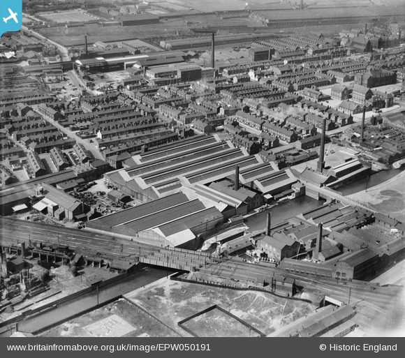
EPW050191 ENGLAND (1936). Ardwick Junction, the R and J Dempster Ltd Gas Plant Works and environs, Newton Heath, 1936
© Copyright OpenStreetMap contributors and licensed by the OpenStreetMap Foundation. 2026. Cartography is licensed as CC BY-SA.
Nearby Images (17)
Details
| Title | [EPW050191] Ardwick Junction, the R and J Dempster Ltd Gas Plant Works and environs, Newton Heath, 1936 |
| Reference | EPW050191 |
| Date | May-1936 |
| Link | |
| Place name | NEWTON HEATH |
| Parish | |
| District | |
| Country | ENGLAND |
| Easting / Northing | 386687, 399943 |
| Longitude / Latitude | -2.2007004803183, 53.495771088911 |
| National Grid Reference | SJ867999 |
Pins

J Ashton |
Saturday 7th of April 2018 01:41:29 PM | |

J Ashton |
Saturday 7th of April 2018 01:40:07 PM | |

John Wass |
Friday 15th of May 2015 08:09:21 PM | |
This actually became Philips Park no.1 (or number 2, I forget now) junction, Newton heath,confusingly it is not located in Ardwick. It was once called Ardwick junction on old OS maps.See here https://maps.nls.uk/geo/explore/#zoom=16.5&lat=53.49482&lon=-2.20437&layers=168&b=1 There is an Ardwick junction at both ends of the line, I suspect the one on the map is named in error, hence the heading on this image perpetuates this.The canal is the Rochdale canal and at the top of the pic are railway concrete works, adjoining Thorpe road at the right hand end. By Barney Rubble. |

Barney Rubble |
Friday 19th of October 2018 02:41:46 PM |
User Comment Contributions
John,,, did you work in Mayfield??? |

Barney Rubble |
Sunday 6th of December 2015 06:35:41 PM |
It is not Ardwick Junction- it is Philips Park Junction, on the LMS (Ex- L&Y) stalybridge branch. The signal box is Philips Park No.1. The canal is the Oldham branch canal from Ducie street area. By Barney Rubble. |

Barney Rubble |
Sunday 6th of December 2015 06:34:41 PM |


![[EPW050191] Ardwick Junction, the R and J Dempster Ltd Gas Plant Works and environs, Newton Heath, 1936](http://britainfromabove.org.uk/sites/all/libraries/aerofilms-images/public/100x100/EPW/050/EPW050191.jpg)
![[EPW050192] Grimshaw Lane, the R and J Dempster Ltd Gas Plant Works and environs, Newton Heath, 1936](http://britainfromabove.org.uk/sites/all/libraries/aerofilms-images/public/100x100/EPW/050/EPW050192.jpg)
![[EPW050197] The R and J Dempster Ltd Gas Plant Works and environs, Newton Heath, 1936](http://britainfromabove.org.uk/sites/all/libraries/aerofilms-images/public/100x100/EPW/050/EPW050197.jpg)
![[EPW050199] The R and J Dempster Ltd Gas Plant Works and environs, Newton Heath, 1936](http://britainfromabove.org.uk/sites/all/libraries/aerofilms-images/public/100x100/EPW/050/EPW050199.jpg)
![[EPW050195] The R and J Dempster Ltd Gas Plant Works, the Rochdale Canal and environs, Newton Heath, 1936](http://britainfromabove.org.uk/sites/all/libraries/aerofilms-images/public/100x100/EPW/050/EPW050195.jpg)
![[EPW050196] The R and J Dempster Ltd Gas Plant Works and environs, Newton Heath, 1936](http://britainfromabove.org.uk/sites/all/libraries/aerofilms-images/public/100x100/EPW/050/EPW050196.jpg)
![[EAW050313] The R & J Dempster Ltd Gas Plant Works and environs, Newton Heath, 1953. This image was marked by Aerofilms Ltd for photo editing.](http://britainfromabove.org.uk/sites/all/libraries/aerofilms-images/public/100x100/EAW/050/EAW050313.jpg)
![[EPW050193] Ardwick Junction, the R and J Dempster Ltd Gas Plant Works and environs, Newton Heath, from the south-west, 1936](http://britainfromabove.org.uk/sites/all/libraries/aerofilms-images/public/100x100/EPW/050/EPW050193.jpg)
![[EAW050312] The R & J Dempster Ltd Gas Plant Works and environs, Newton Heath, 1953. This image was marked by Aerofilms Ltd for photo editing.](http://britainfromabove.org.uk/sites/all/libraries/aerofilms-images/public/100x100/EAW/050/EAW050312.jpg)
![[EPW050198] The R and J Dempster Ltd Gas Plant Works, Rochdale Canal and environs, Newton Heath, from the south-west, 1936](http://britainfromabove.org.uk/sites/all/libraries/aerofilms-images/public/100x100/EPW/050/EPW050198.jpg)
![[EAW050311] The R & J Dempster Ltd Gas Plant Works and environs, Newton Heath, 1953. This image was marked by Aerofilms Ltd for photo editing.](http://britainfromabove.org.uk/sites/all/libraries/aerofilms-images/public/100x100/EAW/050/EAW050311.jpg)
![[EPW050194] The R and J Dempster Ltd Gas Plant Works, Philips Park Sidings and environs, Newton Heath, 1936](http://britainfromabove.org.uk/sites/all/libraries/aerofilms-images/public/100x100/EPW/050/EPW050194.jpg)
![[EAW050314] The R & J Dempster Ltd Gas Plant Works and environs, Newton Heath, 1953. This image was marked by Aerofilms Ltd for photo editing.](http://britainfromabove.org.uk/sites/all/libraries/aerofilms-images/public/100x100/EAW/050/EAW050314.jpg)
![[EAW050315] The R & J Dempster Ltd Gas Plant Works and environs, Newton Heath, 1953. This image was marked by Aerofilms Ltd for photo editing.](http://britainfromabove.org.uk/sites/all/libraries/aerofilms-images/public/100x100/EAW/050/EAW050315.jpg)
![[EAW050316] The R & J Dempster Ltd Gas Plant Works and environs, Newton Heath, 1953. This image was marked by Aerofilms Ltd for photo editing.](http://britainfromabove.org.uk/sites/all/libraries/aerofilms-images/public/100x100/EAW/050/EAW050316.jpg)
![[EAW050310] The R & J Dempster Ltd Gas Plant Works and environs, Newton Heath, 1953. This image was marked by Aerofilms Ltd for photo editing.](http://britainfromabove.org.uk/sites/all/libraries/aerofilms-images/public/100x100/EAW/050/EAW050310.jpg)
![[EAW050317] The R & J Dempster Ltd Gas Plant Works and environs, Newton Heath, 1953. This image was marked by Aerofilms Ltd for photo editing.](http://britainfromabove.org.uk/sites/all/libraries/aerofilms-images/public/100x100/EAW/050/EAW050317.jpg)