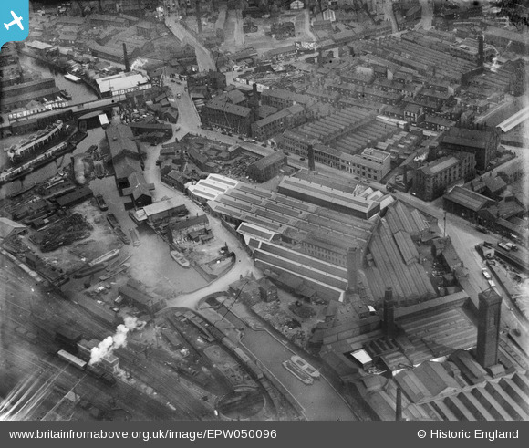
EPW050096 ENGLAND (1936). The R. W. Crabtree and Sons Print Machinery Manufactory and surrounding works, Leeds, 1936
© Copyright OpenStreetMap contributors and licensed by the OpenStreetMap Foundation. 2026. Cartography is licensed as CC BY-SA.
Nearby Images (19)
Details
| Title | [EPW050096] The R. W. Crabtree and Sons Print Machinery Manufactory and surrounding works, Leeds, 1936 |
| Reference | EPW050096 |
| Date | May-1936 |
| Link | |
| Place name | LEEDS |
| Parish | |
| District | |
| Country | ENGLAND |
| Easting / Northing | 429704, 432998 |
| Longitude / Latitude | -1.5490439922544, 53.79223117803 |
| National Grid Reference | SE297330 |
Pins
Be the first to add a comment to this image!


![[EPW050096] The R. W. Crabtree and Sons Print Machinery Manufactory and surrounding works, Leeds, 1936](http://britainfromabove.org.uk/sites/all/libraries/aerofilms-images/public/100x100/EPW/050/EPW050096.jpg)
![[EPW050095] The R. W. Crabtree and Sons Print Machinery Manufactory, Canal Wharf and surrounding works, Leeds, 1936](http://britainfromabove.org.uk/sites/all/libraries/aerofilms-images/public/100x100/EPW/050/EPW050095.jpg)
![[EPW050094] The R. W. Crabtree and Sons Print Machinery Manufactory, Canal Wharf and surrounding works, Leeds, 1936](http://britainfromabove.org.uk/sites/all/libraries/aerofilms-images/public/100x100/EPW/050/EPW050094.jpg)
![[EPW050092] The R. W. Crabtree and Sons Print Machinery Manufactory and surrounding works, Leeds, 1936](http://britainfromabove.org.uk/sites/all/libraries/aerofilms-images/public/100x100/EPW/050/EPW050092.jpg)
![[EPW050097] The R. W. Crabtree and Sons Print Machinery Manufactory and surrounding works, Leeds, 1936](http://britainfromabove.org.uk/sites/all/libraries/aerofilms-images/public/100x100/EPW/050/EPW050097.jpg)
![[EPW050093] The R. W. Crabtree and Sons Print Machinery Manufactory, Canal Wharf and surrounding works, Leeds, 1936](http://britainfromabove.org.uk/sites/all/libraries/aerofilms-images/public/100x100/EPW/050/EPW050093.jpg)
![[EAW044370] Industrial buildings around Water Lane, Leeds, 1952](http://britainfromabove.org.uk/sites/all/libraries/aerofilms-images/public/100x100/EAW/044/EAW044370.jpg)
![[EAW044371] Industrial buildings around Water Lane looking towards Whitehall Junction, Leeds, 1952](http://britainfromabove.org.uk/sites/all/libraries/aerofilms-images/public/100x100/EAW/044/EAW044371.jpg)
![[EAW044373] Industrial buildings around Water Lane, Leeds, 1952](http://britainfromabove.org.uk/sites/all/libraries/aerofilms-images/public/100x100/EAW/044/EAW044373.jpg)
![[EAW044372] Industrial buildings around Water Lane, Leeds, 1952](http://britainfromabove.org.uk/sites/all/libraries/aerofilms-images/public/100x100/EAW/044/EAW044372.jpg)
![[EAW044376] Industrial buildings around Water Lane, Leeds, 1952](http://britainfromabove.org.uk/sites/all/libraries/aerofilms-images/public/100x100/EAW/044/EAW044376.jpg)
![[EAW044374] Industrial buildings around Water Lane and Camp Field, Leeds, 1952](http://britainfromabove.org.uk/sites/all/libraries/aerofilms-images/public/100x100/EAW/044/EAW044374.jpg)
![[EPW050098] The R. W. Crabtree and Sons Print Machinery Manufactory and environs, Leeds, 1936](http://britainfromabove.org.uk/sites/all/libraries/aerofilms-images/public/100x100/EPW/050/EPW050098.jpg)
![[EPW015699] The Whitehall Soap Works and the Central and City Stations, Leeds, 1926](http://britainfromabove.org.uk/sites/all/libraries/aerofilms-images/public/100x100/EPW/015/EPW015699.jpg)
![[EPW015707] The Whitehall Soap Works, Leeds, 1926](http://britainfromabove.org.uk/sites/all/libraries/aerofilms-images/public/100x100/EPW/015/EPW015707.jpg)
![[EPW015703] The Whitehall Soap Works, City Station and City Square area, Leeds, 1926](http://britainfromabove.org.uk/sites/all/libraries/aerofilms-images/public/100x100/EPW/015/EPW015703.jpg)
![[EPW015700] The Whitehall Soap Works, Central Station and the Leeds and Liverpool Canal, Leeds, 1926](http://britainfromabove.org.uk/sites/all/libraries/aerofilms-images/public/100x100/EPW/015/EPW015700.jpg)
![[EPW015706] The Whitehall Soap Works and environs, Leeds, 1926](http://britainfromabove.org.uk/sites/all/libraries/aerofilms-images/public/100x100/EPW/015/EPW015706.jpg)
![[EPW015901] The Whitehall Soap Works and environs, Leeds, 1926. This image has been produced from a copy-negative.](http://britainfromabove.org.uk/sites/all/libraries/aerofilms-images/public/100x100/EPW/015/EPW015901.jpg)