
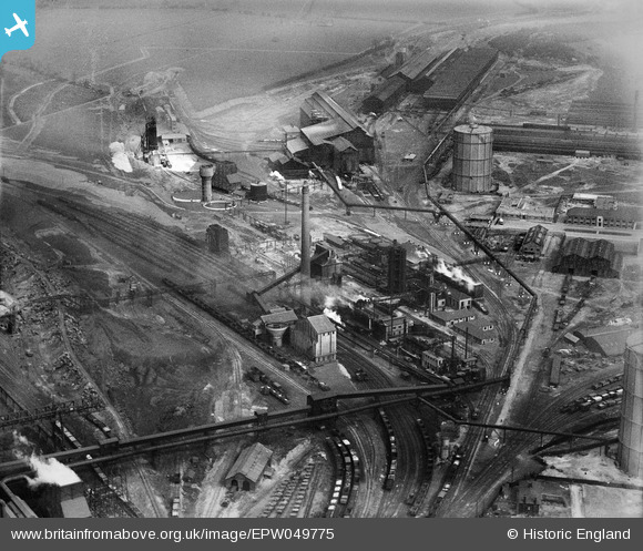
EPW049775 ENGLAND (1936). The By-Product Plant at the Iron and Steel Works, Corby, 1936
© Copyright OpenStreetMap contributors and licensed by the OpenStreetMap Foundation. 2026. Cartography is licensed as CC BY-SA.
Nearby Images (20)
EPW049775

EPW049774

EAW034123

EAW034116

EAW034119

EPW054913

EAW034115

EAW034113

EAW034117

EAW034114

EAW034120

EPW049771

EAW034121

EPW049770

EAW034118

EPW054923

EPW049772

EAW045454
, Corby, from the south-east, 1952")
EPW049767

EAW045439

Details
| Title | [EPW049775] The By-Product Plant at the Iron and Steel Works, Corby, 1936 |
| Reference | EPW049775 |
| Date | March-1936 |
| Link | |
| Place name | CORBY |
| Parish | |
| District | |
| Country | ENGLAND |
| Easting / Northing | 489923, 289474 |
| Longitude / Latitude | -0.67530593638738, 52.495384010537 |
| National Grid Reference | SP899895 |
Pins

MB |
Friday 20th of December 2013 04:53:58 PM |
User Comment Contributions
Herbert Brassert, a German-American engineer, designed the Corby plant, which used the local low-grade, rather acidic, iron ore. In circa 1937-8 Brassert built another new plant for the Nazi party at Salzgitter capable of producing a million tons of steel per annum following completion of construction. Brassert was said to have been involved with as much as twenty per cent of the globe's blast furnaces in the early-mid twentieth century. [Source: Adam Tooze, The Wages of Destruction. The Making & Breaking of the Nazi Economy. Penguin Books, 2007, 235-6] |
MB |
Friday 20th of December 2013 04:54:41 PM |