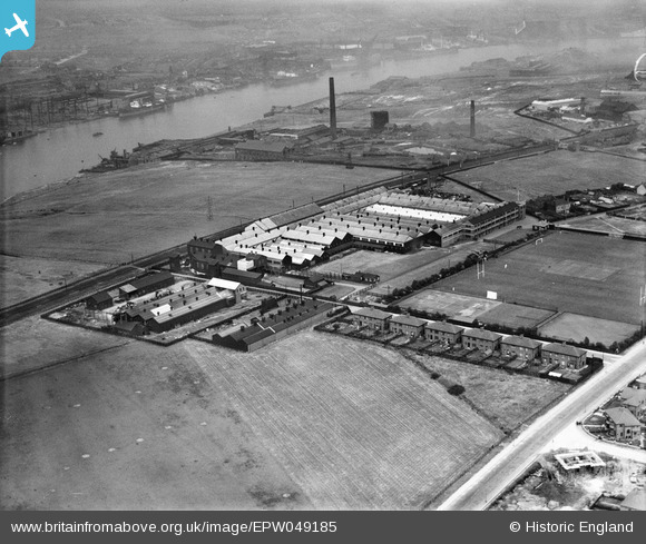
EPW049185 ENGLAND (1935). The Reyrolle Works and Sports Ground, Hebburn, 1935
© Copyright OpenStreetMap contributors and licensed by the OpenStreetMap Foundation. 2026. Cartography is licensed as CC BY-SA.
Nearby Images (16)
Details
| Title | [EPW049185] The Reyrolle Works and Sports Ground, Hebburn, 1935 |
| Reference | EPW049185 |
| Date | September-1935 |
| Link | |
| Place name | HEBBURN |
| Parish | |
| District | |
| Country | ENGLAND |
| Easting / Northing | 430411, 563815 |
| Longitude / Latitude | -1.5249251242762, 54.967952822165 |
| National Grid Reference | NZ304638 |
Pins

N Dunn |
Saturday 15th of October 2016 10:37:11 AM | |

N Dunn |
Thursday 31st of December 2015 02:39:20 PM | |

N Dunn |
Thursday 4th of July 2013 03:42:36 PM | |

N Dunn |
Thursday 4th of July 2013 03:41:12 PM | |

N Dunn |
Thursday 4th of July 2013 03:40:49 PM |


![[EPW049185] The Reyrolle Works and Sports Ground, Hebburn, 1935](http://britainfromabove.org.uk/sites/all/libraries/aerofilms-images/public/100x100/EPW/049/EPW049185.jpg)
![[EPW049183] The Reyrolle Works and Sports Ground, Hebburn, 1935. This image was marked by Aerofilms Ltd for photo editing.](http://britainfromabove.org.uk/sites/all/libraries/aerofilms-images/public/100x100/EPW/049/EPW049183.jpg)
![[EPW049187] The Reyrolle Works and Sports Ground, Hebburn, 1935](http://britainfromabove.org.uk/sites/all/libraries/aerofilms-images/public/100x100/EPW/049/EPW049187.jpg)
![[EAW033929] The Reyrolle Electrical Engineering Works and environs, Hebburn, 1950. This image has been produced from a damaged negative.](http://britainfromabove.org.uk/sites/all/libraries/aerofilms-images/public/100x100/EAW/033/EAW033929.jpg)
![[EAW033931] The Reyrolle Electrical Engineering Works and environs, Hebburn, 1950. This image was marked by Aerofilms Ltd for photo editing.](http://britainfromabove.org.uk/sites/all/libraries/aerofilms-images/public/100x100/EAW/033/EAW033931.jpg)
![[EPW049186] The Reyrolle Works and Sports Ground, Hebburn, 1935](http://britainfromabove.org.uk/sites/all/libraries/aerofilms-images/public/100x100/EPW/049/EPW049186.jpg)
![[EAW033925] The Reyrolle Electrical Engineering Works and environs, Hebburn, 1950. This image was marked by Aerofilms Ltd for photo editing.](http://britainfromabove.org.uk/sites/all/libraries/aerofilms-images/public/100x100/EAW/033/EAW033925.jpg)
![[EAW033930] The Reyrolle Electrical Engineering Works (site of) and environs, Hebburn, 1950. This image has been produced from a damaged negative.](http://britainfromabove.org.uk/sites/all/libraries/aerofilms-images/public/100x100/EAW/033/EAW033930.jpg)
![[EAW033919] The Reyrolle Electrical Engineering Works and environs, Hebburn, 1950. This image was marked by Aerofilms Ltd for photo editing.](http://britainfromabove.org.uk/sites/all/libraries/aerofilms-images/public/100x100/EAW/033/EAW033919.jpg)
![[EAW033932] The Reyrolle Electrical Engineering Works and environs, Hebburn, 1950. This image was marked by Aerofilms Ltd for photo editing.](http://britainfromabove.org.uk/sites/all/libraries/aerofilms-images/public/100x100/EAW/033/EAW033932.jpg)
![[EAW033921] The Reyrolle Electrical Engineering Works and environs, Hebburn, 1950. This image was marked by Aerofilms Ltd for photo editing.](http://britainfromabove.org.uk/sites/all/libraries/aerofilms-images/public/100x100/EAW/033/EAW033921.jpg)
![[EPW013982] The Reyrolle Works and Sports Ground, Hebburn, 1925](http://britainfromabove.org.uk/sites/all/libraries/aerofilms-images/public/100x100/EPW/013/EPW013982.jpg)
![[EPW049184] The Reyrolle Works and Sports Ground, Hebburn, 1935](http://britainfromabove.org.uk/sites/all/libraries/aerofilms-images/public/100x100/EPW/049/EPW049184.jpg)
![[EAW033920] The Reyrolle Electrical Engineering Works and environs, Hebburn, 1950. This image was marked by Aerofilms Ltd for photo editing.](http://britainfromabove.org.uk/sites/all/libraries/aerofilms-images/public/100x100/EAW/033/EAW033920.jpg)
![[EAW033924] Hebburn Cemetery, the Reyrolle Electrical Engineering Works and environs, Hebburn, 1950. This image was marked by Aerofilms Ltd for photo editing.](http://britainfromabove.org.uk/sites/all/libraries/aerofilms-images/public/100x100/EAW/033/EAW033924.jpg)
![[EAW033922] The Reyrolle Electrical Engineering Works and environs, Hebburn, 1950. This image was marked by Aerofilms Ltd for photo editing.](http://britainfromabove.org.uk/sites/all/libraries/aerofilms-images/public/100x100/EAW/033/EAW033922.jpg)