
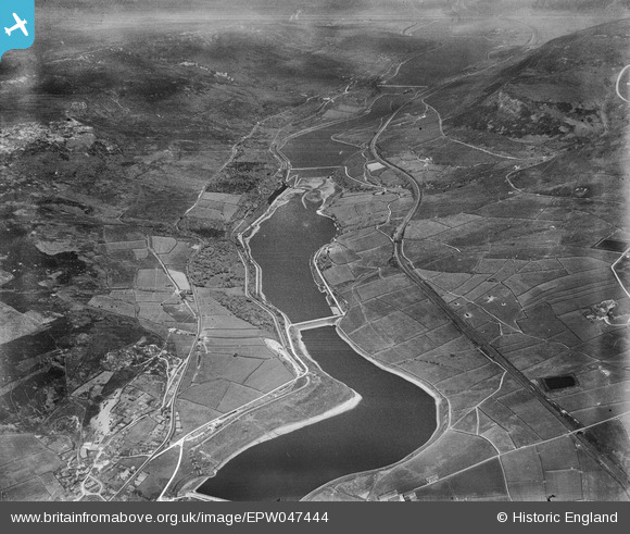
EPW047444 ENGLAND (1935). Bottoms, Valehouse, Rhodeswood and Torside Reservoirs, Longdendale, from the south-west, 1935
© Copyright OpenStreetMap contributors and licensed by the OpenStreetMap Foundation. 2025. Cartography is licensed as CC BY-SA.
Nearby Images (7)
EPW047444

EPW047447

EPW047450

EPW047448

EAW051438

EPW047445

EPW047442

Details
| Title | [EPW047444] Bottoms, Valehouse, Rhodeswood and Torside Reservoirs, Longdendale, from the south-west, 1935 |
| Reference | EPW047444 |
| Date | May-1935 |
| Link | |
| Place name | LONGDENDALE |
| Parish | TINTWISTLE |
| District | |
| Country | ENGLAND |
| Easting / Northing | 402985, 397257 |
| Longitude / Latitude | -1.9550249559919, 53.471785351815 |
| National Grid Reference | SK030973 |
Pins
Be the first to add a comment to this image!
User Comment Contributions
To the right of the y junction,prominant in the lower LH quarter of the picture is the reservoir maintenance centre.It had a hydro electric powered railwaythe track of which leaves the yard on the right hand side of the road and curves to the left ,crossing the road just before the road its self turns left to run up the valley.If you track back along the line to the works It appears that there is a train standing on the line by the darker of the two long sheds.It was a 3 ft gauge line and quite advanced in using electricity.In later years this was suspended and internal combustion power was substituted.On the right hand side is the main line which followed the water works lead,after50 years,and was an early overhead electrification scheme in late 1940 |

fergus |
Saturday 19th of March 2016 12:32:55 PM |