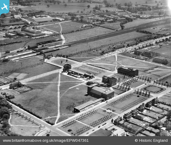
EPW047361 ENGLAND (1935). Howardsgate and the railway station, Welwyn Garden City, 1935
© Copyright OpenStreetMap contributors and licensed by the OpenStreetMap Foundation. 2026. Cartography is licensed as CC BY-SA.
Nearby Images (29)
Details
| Title | [EPW047361] Howardsgate and the railway station, Welwyn Garden City, 1935 |
| Reference | EPW047361 |
| Date | May-1935 |
| Link | |
| Place name | WELWYN GARDEN CITY |
| Parish | |
| District | |
| Country | ENGLAND |
| Easting / Northing | 523768, 212958 |
| Longitude / Latitude | -0.2048328485012, 51.801102107438 |
| National Grid Reference | TL238130 |
Pins
Be the first to add a comment to this image!


![[EPW047361] Howardsgate and the railway station, Welwyn Garden City, 1935](http://britainfromabove.org.uk/sites/all/libraries/aerofilms-images/public/100x100/EPW/047/EPW047361.jpg)
![[EPW054496] Howardsgate, the Railway Station and the Shredded Wheat Cereal Manufactory, Welwyn Garden City, 1937](http://britainfromabove.org.uk/sites/all/libraries/aerofilms-images/public/100x100/EPW/054/EPW054496.jpg)
![[EAW013995] Parkway, the town and environs, Welwyn Garden City, from the north-east, 1948](http://britainfromabove.org.uk/sites/all/libraries/aerofilms-images/public/100x100/EAW/013/EAW013995.jpg)
![[EPW047364] Howardsgate and the railway station, Welwyn Garden City, 1935](http://britainfromabove.org.uk/sites/all/libraries/aerofilms-images/public/100x100/EPW/047/EPW047364.jpg)
![[EPW054497] Howardsgate, Welwyn Garden City, 1937](http://britainfromabove.org.uk/sites/all/libraries/aerofilms-images/public/100x100/EPW/054/EPW054497.jpg)
![[EPW054533] Howardsgate and Stonehills, Welwyn Garden City, 1937](http://britainfromabove.org.uk/sites/all/libraries/aerofilms-images/public/100x100/EPW/054/EPW054533.jpg)
![[EPW047363] Howardsgate, Welwyn Garden City, 1935](http://britainfromabove.org.uk/sites/all/libraries/aerofilms-images/public/100x100/EPW/047/EPW047363.jpg)
![[EPW047365] Howardsgate and environs, Welwyn Garden City, 1935](http://britainfromabove.org.uk/sites/all/libraries/aerofilms-images/public/100x100/EPW/047/EPW047365.jpg)
![[EPW054493] Howardsgate and the town centre, Welwyn Garden City, 1937](http://britainfromabove.org.uk/sites/all/libraries/aerofilms-images/public/100x100/EPW/054/EPW054493.jpg)
![[EPW047362] Howardsgate and the railway station, Welwyn Garden City, 1935](http://britainfromabove.org.uk/sites/all/libraries/aerofilms-images/public/100x100/EPW/047/EPW047362.jpg)
![[EPW054513] The Railway Station, Howardsgate and Church Road, Welwyn Garden City, 1937](http://britainfromabove.org.uk/sites/all/libraries/aerofilms-images/public/100x100/EPW/054/EPW054513.jpg)
![[EPW022015] The Ebenezer Howard Memorial and the Shredded Wheat Factory, Welwyn Garden City, from the north-west, 1928](http://britainfromabove.org.uk/sites/all/libraries/aerofilms-images/public/100x100/EPW/022/EPW022015.jpg)
![[EPW054498] Howardsgate and the Shredded Wheat Cereal Manufactory, Welwyn Garden City, 1937](http://britainfromabove.org.uk/sites/all/libraries/aerofilms-images/public/100x100/EPW/054/EPW054498.jpg)
![[EPW025528] The Welwyn Theatre off Parkway, Welwyn Garden City, 1928. This image has been produced from a copy-negative.](http://britainfromabove.org.uk/sites/all/libraries/aerofilms-images/public/100x100/EPW/025/EPW025528.jpg)
![[EPW047342] Handside and the town, Welwyn Garden City, 1935](http://britainfromabove.org.uk/sites/all/libraries/aerofilms-images/public/100x100/EPW/047/EPW047342.jpg)
![[EPW022023] Crowds at Parkway and Howards Gate, Welwyn Garden City, 1928](http://britainfromabove.org.uk/sites/all/libraries/aerofilms-images/public/100x100/EPW/022/EPW022023.jpg)
![[EPW022017] The Cottage and the Ebenezer Howard Memorial, Welwyn Garden City, 1928](http://britainfromabove.org.uk/sites/all/libraries/aerofilms-images/public/100x100/EPW/022/EPW022017.jpg)
![[EPW054494] The Railway Station, Howardsgate and Parkway, Welwyn Garden City, 1937](http://britainfromabove.org.uk/sites/all/libraries/aerofilms-images/public/100x100/EPW/054/EPW054494.jpg)
![[EAW035461] The town and surrounding countryside, Welwyn Garden City, 1951. This image has been produced from a print.](http://britainfromabove.org.uk/sites/all/libraries/aerofilms-images/public/100x100/EAW/035/EAW035461.jpg)
![[EPW062006] Welwyn Garden City, the Grand Opening of Welwyn Stores, 1939](http://britainfromabove.org.uk/sites/all/libraries/aerofilms-images/public/100x100/EPW/062/EPW062006.jpg)
![[EPW062002] Welwyn Garden City, the Grand Opening of Welwyn Stores, 1939](http://britainfromabove.org.uk/sites/all/libraries/aerofilms-images/public/100x100/EPW/062/EPW062002.jpg)
![[EPW022024] Crowds at Parkway and The Welwyn Theatre, Welwyn Garden City, 1928](http://britainfromabove.org.uk/sites/all/libraries/aerofilms-images/public/100x100/EPW/022/EPW022024.jpg)
![[EPW062005] Welwyn Garden City, the Grand Opening of Welwyn Stores, 1939](http://britainfromabove.org.uk/sites/all/libraries/aerofilms-images/public/100x100/EPW/062/EPW062005.jpg)
![[EPW062001] Welwyn Garden City, the Grand Opening of Welwyn Stores, 1939](http://britainfromabove.org.uk/sites/all/libraries/aerofilms-images/public/100x100/EPW/062/EPW062001.jpg)
![[EPW062003] Welwyn Garden City, the Grand Opening of Welwyn Stores, 1939](http://britainfromabove.org.uk/sites/all/libraries/aerofilms-images/public/100x100/EPW/062/EPW062003.jpg)
![[EPW022026] Parkway, Welwyn Garden City, 1928](http://britainfromabove.org.uk/sites/all/libraries/aerofilms-images/public/100x100/EPW/022/EPW022026.jpg)
![[EPW054505] The Cherry Tree Restaurant, Welwyn Garden City, 1937](http://britainfromabove.org.uk/sites/all/libraries/aerofilms-images/public/100x100/EPW/054/EPW054505.jpg)
![[EPW025536] Rosanne House on Bridge Road, Welwyn Garden City, 1928. This image has been produced from a damaged negative.](http://britainfromabove.org.uk/sites/all/libraries/aerofilms-images/public/100x100/EPW/025/EPW025536.jpg)
![[EPW062075] The town, Welwyn Garden City, 1939](http://britainfromabove.org.uk/sites/all/libraries/aerofilms-images/public/100x100/EPW/062/EPW062075.jpg)