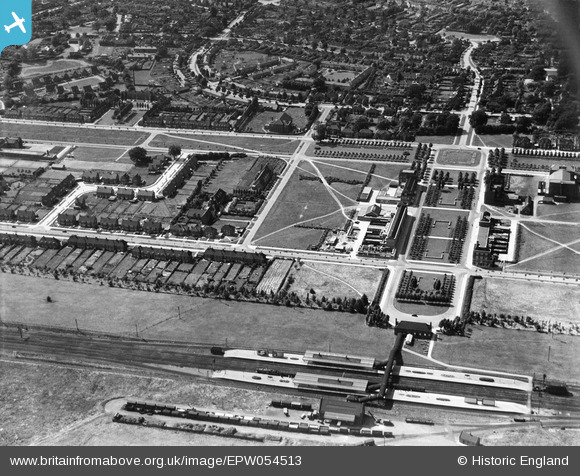
EPW054513 ENGLAND (1937). The Railway Station, Howardsgate and Church Road, Welwyn Garden City, 1937
© Copyright OpenStreetMap contributors and licensed by the OpenStreetMap Foundation. 2026. Cartography is licensed as CC BY-SA.
Nearby Images (21)
Details
| Title | [EPW054513] The Railway Station, Howardsgate and Church Road, Welwyn Garden City, 1937 |
| Reference | EPW054513 |
| Date | 30-July-1937 |
| Link | |
| Place name | WELWYN GARDEN CITY |
| Parish | |
| District | |
| Country | ENGLAND |
| Easting / Northing | 523732, 212836 |
| Longitude / Latitude | -0.20539827388373, 51.800013584647 |
| National Grid Reference | TL237128 |
Pins

John W |
Wednesday 22nd of March 2017 10:33:42 PM | |

John W |
Wednesday 22nd of March 2017 07:56:53 PM | |

John W |
Wednesday 22nd of March 2017 07:54:07 PM | |

John W |
Wednesday 22nd of March 2017 07:53:37 PM | |

John W |
Wednesday 22nd of March 2017 07:52:14 PM | |

John W |
Wednesday 22nd of March 2017 07:51:39 PM | |

John W |
Wednesday 22nd of March 2017 07:50:45 PM | |

John W |
Wednesday 22nd of March 2017 07:49:32 PM | |

John W |
Wednesday 22nd of March 2017 07:35:35 PM | |

John W |
Wednesday 22nd of March 2017 07:35:08 PM |


![[EPW054513] The Railway Station, Howardsgate and Church Road, Welwyn Garden City, 1937](http://britainfromabove.org.uk/sites/all/libraries/aerofilms-images/public/100x100/EPW/054/EPW054513.jpg)
![[EPW047342] Handside and the town, Welwyn Garden City, 1935](http://britainfromabove.org.uk/sites/all/libraries/aerofilms-images/public/100x100/EPW/047/EPW047342.jpg)
![[EPW022017] The Cottage and the Ebenezer Howard Memorial, Welwyn Garden City, 1928](http://britainfromabove.org.uk/sites/all/libraries/aerofilms-images/public/100x100/EPW/022/EPW022017.jpg)
![[EAW013995] Parkway, the town and environs, Welwyn Garden City, from the north-east, 1948](http://britainfromabove.org.uk/sites/all/libraries/aerofilms-images/public/100x100/EAW/013/EAW013995.jpg)
![[EPW054494] The Railway Station, Howardsgate and Parkway, Welwyn Garden City, 1937](http://britainfromabove.org.uk/sites/all/libraries/aerofilms-images/public/100x100/EPW/054/EPW054494.jpg)
![[EPW047361] Howardsgate and the railway station, Welwyn Garden City, 1935](http://britainfromabove.org.uk/sites/all/libraries/aerofilms-images/public/100x100/EPW/047/EPW047361.jpg)
![[EPW054496] Howardsgate, the Railway Station and the Shredded Wheat Cereal Manufactory, Welwyn Garden City, 1937](http://britainfromabove.org.uk/sites/all/libraries/aerofilms-images/public/100x100/EPW/054/EPW054496.jpg)
![[EAW035461] The town and surrounding countryside, Welwyn Garden City, 1951. This image has been produced from a print.](http://britainfromabove.org.uk/sites/all/libraries/aerofilms-images/public/100x100/EAW/035/EAW035461.jpg)
![[EPW047365] Howardsgate and environs, Welwyn Garden City, 1935](http://britainfromabove.org.uk/sites/all/libraries/aerofilms-images/public/100x100/EPW/047/EPW047365.jpg)
![[EPW047364] Howardsgate and the railway station, Welwyn Garden City, 1935](http://britainfromabove.org.uk/sites/all/libraries/aerofilms-images/public/100x100/EPW/047/EPW047364.jpg)
![[EPW047362] Howardsgate and the railway station, Welwyn Garden City, 1935](http://britainfromabove.org.uk/sites/all/libraries/aerofilms-images/public/100x100/EPW/047/EPW047362.jpg)
![[EPW062075] The town, Welwyn Garden City, 1939](http://britainfromabove.org.uk/sites/all/libraries/aerofilms-images/public/100x100/EPW/062/EPW062075.jpg)
![[EPW054497] Howardsgate, Welwyn Garden City, 1937](http://britainfromabove.org.uk/sites/all/libraries/aerofilms-images/public/100x100/EPW/054/EPW054497.jpg)
![[EPW054533] Howardsgate and Stonehills, Welwyn Garden City, 1937](http://britainfromabove.org.uk/sites/all/libraries/aerofilms-images/public/100x100/EPW/054/EPW054533.jpg)
![[EPW047363] Howardsgate, Welwyn Garden City, 1935](http://britainfromabove.org.uk/sites/all/libraries/aerofilms-images/public/100x100/EPW/047/EPW047363.jpg)
![[EPW054493] Howardsgate and the town centre, Welwyn Garden City, 1937](http://britainfromabove.org.uk/sites/all/libraries/aerofilms-images/public/100x100/EPW/054/EPW054493.jpg)
![[EPW054538] The residential area surrounding Lytton Gardens and Parkfields, Handside, 1937. This image has been affected by flare.](http://britainfromabove.org.uk/sites/all/libraries/aerofilms-images/public/100x100/EPW/054/EPW054538.jpg)
![[EPW022015] The Ebenezer Howard Memorial and the Shredded Wheat Factory, Welwyn Garden City, from the north-west, 1928](http://britainfromabove.org.uk/sites/all/libraries/aerofilms-images/public/100x100/EPW/022/EPW022015.jpg)
![[EAW013993] Parkway and the surrounding town, Welwyn Garden City, 1948](http://britainfromabove.org.uk/sites/all/libraries/aerofilms-images/public/100x100/EAW/013/EAW013993.jpg)
![[EPW054498] Howardsgate and the Shredded Wheat Cereal Manufactory, Welwyn Garden City, 1937](http://britainfromabove.org.uk/sites/all/libraries/aerofilms-images/public/100x100/EPW/054/EPW054498.jpg)
![[EPW062076] The town, Welwyn Garden City, 1939. This image has been affected by flare.](http://britainfromabove.org.uk/sites/all/libraries/aerofilms-images/public/100x100/EPW/062/EPW062076.jpg)