
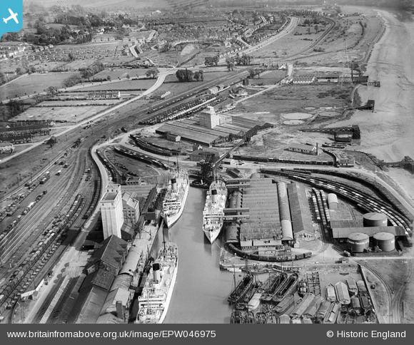
EPW046975 ENGLAND (1935). Avonmouth Dock, Cellactite and British Uralite Ltd and environs, Avonmouth, from the north-west, 1935
© Copyright OpenStreetMap contributors and licensed by the OpenStreetMap Foundation. 2026. Cartography is licensed as CC BY-SA.
Nearby Images (20)
EPW046975

EPW019270

EAW002072

EPW027946

EAW002253

EPW005516

EPR000061

EPR000060

EPW046976

EPW046971

EPW046979

EPW046977

EPW046973

EPW046978

EPW046972

EPW011976

EPR000059

EPW027954

EPR000058

EPW027951

Details
| Title | [EPW046975] Avonmouth Dock, Cellactite and British Uralite Ltd and environs, Avonmouth, from the north-west, 1935 |
| Reference | EPW046975 |
| Date | May-1935 |
| Link | |
| Place name | AVONMOUTH |
| Parish | |
| District | |
| Country | ENGLAND |
| Easting / Northing | 351541, 177748 |
| Longitude / Latitude | -2.6981397804744, 51.496110229562 |
| National Grid Reference | ST515777 |
Pins

RDF |
Wednesday 21st of February 2024 12:22:26 PM | |
|
MB |
Saturday 20th of August 2016 05:06:30 PM | |
|
pewseyfam |
Sunday 3rd of August 2014 10:38:38 PM | |
|
pewseyfam |
Sunday 3rd of August 2014 10:37:55 PM | |
Built on or after 1935 |
MB |
Saturday 20th of August 2016 05:07:14 PM |
|
pewseyfam |
Sunday 3rd of August 2014 10:37:52 PM | |
|
rog8811 |
Sunday 5th of May 2013 06:12:49 PM |