
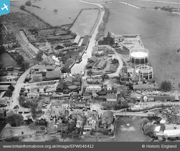
EPW046412 ENGLAND (1934). Brown and Sons Timber Yard on Navigation Road, the Chelmsford Corporation Gas Works and environs, Chelmsford, 1934
© Copyright OpenStreetMap contributors and licensed by the OpenStreetMap Foundation. 2026. Cartography is licensed as CC BY-SA.
Nearby Images (21)
EPW046412

EPW009560

EPW046419

EPW009554

EPW046420

EPW046450

EPW046415

EPW046453

EPW046452

EPW046454

EPW046451

EPW046449

EPW016553

EPW016553
EPW046417

EPW046418

EPW046411

EPW046416

EPW046414

EPW046410

EPW046413

Details
| Title | [EPW046412] Brown and Sons Timber Yard on Navigation Road, the Chelmsford Corporation Gas Works and environs, Chelmsford, 1934 |
| Reference | EPW046412 |
| Date | October-1934 |
| Link | |
| Place name | CHELMSFORD |
| Parish | |
| District | |
| Country | ENGLAND |
| Easting / Northing | 571299, 206672 |
| Longitude / Latitude | 0.4808698059832, 51.732091981865 |
| National Grid Reference | TL713067 |
Pins

Ian |
Sunday 8th of November 2015 09:28:02 AM | |
|
Ian |
Sunday 8th of November 2015 09:26:38 AM | |
|
Ian |
Sunday 8th of November 2015 09:25:04 AM | |
|
Ian |
Sunday 8th of November 2015 09:08:23 AM | |
|
Ian |
Sunday 8th of November 2015 09:01:44 AM | |
|
Ian |
Sunday 8th of November 2015 08:59:27 AM | |
|
Ian |
Sunday 26th of January 2014 08:32:39 PM | |
|
Ian |
Saturday 25th of January 2014 03:00:12 PM | |
|
Ian |
Sunday 19th of January 2014 05:22:59 PM | |
|
Ian |
Sunday 19th of January 2014 05:15:35 PM | |
|
Ian |
Sunday 19th of January 2014 05:14:57 PM | |
|
Ian |
Sunday 19th of January 2014 05:14:31 PM | |
|
Ian |
Sunday 19th of January 2014 05:13:57 PM |