
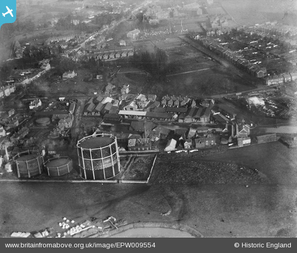
EPW009554 ENGLAND (1923). Timber yards and wharves beside Chelmsford Corporation Gas Works, Chelmsford, 1923
© Copyright OpenStreetMap contributors and licensed by the OpenStreetMap Foundation. 2026. Cartography is licensed as CC BY-SA.
Nearby Images (21)
EPW009554

EPW009560

EPW046415

EPW046411

EPW046412

EPW046414

EPW046410

EPW016553

EPW016553
EPW046413

EPW046419

EPW058735

EPW046420

EPW046450

EPW046453

EPW046452

EPW046454

EPW046451

EPW046449

EPW046417

EPW046418

Details
| Title | [EPW009554] Timber yards and wharves beside Chelmsford Corporation Gas Works, Chelmsford, 1923 |
| Reference | EPW009554 |
| Date | 1923 |
| Link | |
| Place name | CHELMSFORD |
| Parish | |
| District | |
| Country | ENGLAND |
| Easting / Northing | 571395, 206647 |
| Longitude / Latitude | 0.4822464269312, 51.731838043826 |
| National Grid Reference | TL714066 |
Pins

Ian |
Monday 16th of June 2014 08:38:31 PM | |
|
Ian |
Monday 16th of June 2014 08:37:57 PM | |
|
Ian |
Monday 16th of June 2014 08:36:37 PM | |
|
Ian |
Monday 16th of June 2014 08:36:04 PM | |
|
Ian |
Sunday 19th of January 2014 04:37:24 PM | |
|
Ian |
Sunday 19th of January 2014 02:38:41 PM | |
|
Ian |
Sunday 19th of January 2014 02:36:24 PM | |
|
Ian |
Sunday 19th of January 2014 02:35:32 PM | |
|
Ian |
Sunday 19th of January 2014 02:34:40 PM | |
|
Ian |
Sunday 19th of January 2014 02:34:04 PM | |
|
Ian |
Sunday 19th of January 2014 02:33:32 PM | |
|
Ian |
Sunday 19th of January 2014 02:32:54 PM |