
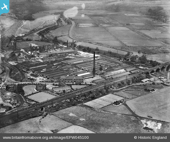
EPW045100 ENGLAND (1934). The Chloride Electrical Storage Works, Clifton Junction, 1934
© Copyright OpenStreetMap contributors and licensed by the OpenStreetMap Foundation. 2026. Cartography is licensed as CC BY-SA.
Nearby Images (33)
EPW045100

EPW037066

EPW045104

EPW045102

EPW037060

EPW037063

EPW045106

EPW044419

EPW045101

EPW013132

EPW044415

EPW037064

EPW045105

EPW045103

EPW044414

EPW044416

EPW037059

EPW037065

EPW044420

EPW037058

EPW037062

EPW037061

EPW057311

EPW057309

EPW057310

EPW057312

EPW057313

EPW044418

EPW057307

EPW057306

EPW057308

EPW044413

EPW044417

Details
| Title | [EPW045100] The Chloride Electrical Storage Works, Clifton Junction, 1934 |
| Reference | EPW045100 |
| Date | July-1934 |
| Link | |
| Place name | CLIFTON JUNCTION |
| Parish | |
| District | |
| Country | ENGLAND |
| Easting / Northing | 379148, 403290 |
| Longitude / Latitude | -2.3145760562887, 53.525613459741 |
| National Grid Reference | SD791033 |
Pins

edqdpmad |
Wednesday 5th of June 2013 08:16:52 PM | |
|
edqdpmad |
Wednesday 5th of June 2013 08:14:50 PM | |
|
edqdpmad |
Wednesday 5th of June 2013 08:13:38 PM | |
|
edqdpmad |
Wednesday 5th of June 2013 08:12:43 PM | |
|
edqdpmad |
Wednesday 5th of June 2013 08:10:40 PM |


User Comment Contributions
The canal through Clifton |
parrot |
Thursday 23rd of May 2013 05:52:46 PM |