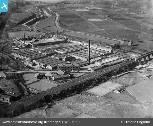
EPW037060 ENGLAND (1931). The Chloride Electrical Storage Works and the Clifton Junction Sewage Farm, Clifton Junction, 1931
© Copyright OpenStreetMap contributors and licensed by the OpenStreetMap Foundation. 2026. Cartography is licensed as CC BY-SA.
Nearby Images (32)
Details
| Title | [EPW037060] The Chloride Electrical Storage Works and the Clifton Junction Sewage Farm, Clifton Junction, 1931 |
| Reference | EPW037060 |
| Date | October-1931 |
| Link | |
| Place name | CLIFTON JUNCTION |
| Parish | |
| District | |
| Country | ENGLAND |
| Easting / Northing | 379163, 403265 |
| Longitude / Latitude | -2.3143481041361, 53.525389322647 |
| National Grid Reference | SD792033 |
Pins

micky |
Wednesday 28th of May 2025 06:58:44 PM | |

micky |
Sunday 9th of March 2025 01:50:52 PM | |

micky |
Sunday 9th of March 2025 01:48:03 PM | |

micky |
Sunday 9th of March 2025 01:40:42 PM | |

micky |
Sunday 9th of March 2025 01:39:38 PM | |

micky |
Sunday 9th of March 2025 01:33:21 PM | |

micky |
Sunday 9th of March 2025 01:32:25 PM | |

micky |
Sunday 9th of March 2025 01:29:27 PM | |

micky |
Sunday 9th of March 2025 01:26:14 PM | |

micky |
Sunday 9th of March 2025 01:25:44 PM | |

micky |
Sunday 9th of March 2025 01:25:03 PM | |

micky |
Sunday 9th of March 2025 01:23:08 PM | |

micky |
Sunday 9th of March 2025 01:22:45 PM | |

micky |
Sunday 9th of March 2025 01:20:46 PM | |

micky |
Sunday 9th of March 2025 01:20:03 PM | |

micky |
Sunday 9th of March 2025 01:19:35 PM | |

micky |
Sunday 9th of March 2025 01:18:40 PM | |

micky |
Sunday 9th of March 2025 01:17:58 PM | |

micky |
Sunday 9th of March 2025 01:16:58 PM | |

micky |
Sunday 9th of March 2025 01:16:08 PM | |

micky |
Monday 30th of March 2020 05:43:54 PM | |

coops |
Thursday 24th of May 2018 01:02:41 PM | |

parrot |
Monday 20th of May 2013 06:20:45 PM | |

parrot |
Monday 20th of May 2013 06:13:44 PM | |

parrot |
Monday 20th of May 2013 06:12:39 PM | |

parrot |
Monday 20th of May 2013 06:12:21 PM | |

parrot |
Monday 20th of May 2013 06:11:50 PM | |

parrot |
Monday 20th of May 2013 06:11:27 PM | |

parrot |
Monday 20th of May 2013 06:11:05 PM | |
called Pack Saddle Bridge |

coops |
Sunday 13th of November 2016 08:49:49 PM |

parrot |
Monday 20th of May 2013 06:10:42 PM |
User Comment Contributions

parrot |
Thursday 23rd of May 2013 02:38:34 PM |


![[EPW037060] The Chloride Electrical Storage Works and the Clifton Junction Sewage Farm, Clifton Junction, 1931](http://britainfromabove.org.uk/sites/all/libraries/aerofilms-images/public/100x100/EPW/037/EPW037060.jpg)
![[EPW045102] The Chloride Electrical Storage Works, Clifton Junction, 1934](http://britainfromabove.org.uk/sites/all/libraries/aerofilms-images/public/100x100/EPW/045/EPW045102.jpg)
![[EPW037066] The Chloride Electrical Storage Works and Pilkington's Tile and Pottery Works, Clifton Junction, 1931](http://britainfromabove.org.uk/sites/all/libraries/aerofilms-images/public/100x100/EPW/037/EPW037066.jpg)
![[EPW045104] The Chloride Electrical Storage Works, Clifton Junction, 1934](http://britainfromabove.org.uk/sites/all/libraries/aerofilms-images/public/100x100/EPW/045/EPW045104.jpg)
![[EPW037063] The Chloride Electrical Storage Works and the Clifton Viaduct, Clifton Junction, 1931](http://britainfromabove.org.uk/sites/all/libraries/aerofilms-images/public/100x100/EPW/037/EPW037063.jpg)
![[EPW037064] The Chloride Electrical Storage Works and the Clifton Viaduct, Clifton Junction, 1931](http://britainfromabove.org.uk/sites/all/libraries/aerofilms-images/public/100x100/EPW/037/EPW037064.jpg)
![[EPW044415] The Chloride Electrical Storage Company Exide Works, the Pilkington Tile and Pottery Works, and the cricket ground, Clifton Junction, 1934](http://britainfromabove.org.uk/sites/all/libraries/aerofilms-images/public/100x100/EPW/044/EPW044415.jpg)
![[EPW045100] The Chloride Electrical Storage Works, Clifton Junction, 1934](http://britainfromabove.org.uk/sites/all/libraries/aerofilms-images/public/100x100/EPW/045/EPW045100.jpg)
![[EPW044419] The Chloride Electrical Storage Company Exide Works, Clifton Junction, 1934. This image has been produced from a damaged negative.](http://britainfromabove.org.uk/sites/all/libraries/aerofilms-images/public/100x100/EPW/044/EPW044419.jpg)
![[EPW044414] The Chloride Electrical Storage Company Exide Works, Clifton Junction, 1934](http://britainfromabove.org.uk/sites/all/libraries/aerofilms-images/public/100x100/EPW/044/EPW044414.jpg)
![[EPW044416] The Chloride Electrical Storage Company Exide Works and environs, Clifton Junction, 1934](http://britainfromabove.org.uk/sites/all/libraries/aerofilms-images/public/100x100/EPW/044/EPW044416.jpg)
![[EPW045106] The Chloride Electrical Storage Works, Clifton Junction, 1934](http://britainfromabove.org.uk/sites/all/libraries/aerofilms-images/public/100x100/EPW/045/EPW045106.jpg)
![[EPW045101] The Chloride Electrical Storage Works, Clifton Junction, 1934](http://britainfromabove.org.uk/sites/all/libraries/aerofilms-images/public/100x100/EPW/045/EPW045101.jpg)
![[EPW013132] The Exide Battery Works, Clifton Junction, 1925. This image has been produced from a print.](http://britainfromabove.org.uk/sites/all/libraries/aerofilms-images/public/100x100/EPW/013/EPW013132.jpg)
![[EPW037059] The Chloride Electrical Storage Works, Clifton Junction, 1931](http://britainfromabove.org.uk/sites/all/libraries/aerofilms-images/public/100x100/EPW/037/EPW037059.jpg)
![[EPW045105] The Chloride Electrical Storage Works, Clifton Junction, 1934](http://britainfromabove.org.uk/sites/all/libraries/aerofilms-images/public/100x100/EPW/045/EPW045105.jpg)
![[EPW037065] The Chloride Electrical Storage Works and the Clifton Viaduct, Clifton Junction, 1931](http://britainfromabove.org.uk/sites/all/libraries/aerofilms-images/public/100x100/EPW/037/EPW037065.jpg)
![[EPW044420] The Chloride Electrical Storage Company Exide Works, Clifton Junction, 1934. This image has been produced from a damaged negative.](http://britainfromabove.org.uk/sites/all/libraries/aerofilms-images/public/100x100/EPW/044/EPW044420.jpg)
![[EPW037058] The Chloride Electrical Storage Works, Clifton Junction, 1931](http://britainfromabove.org.uk/sites/all/libraries/aerofilms-images/public/100x100/EPW/037/EPW037058.jpg)
![[EPW037062] The Chloride Electrical Storage Works and surrounding countryside, Clifton Junction, 1931](http://britainfromabove.org.uk/sites/all/libraries/aerofilms-images/public/100x100/EPW/037/EPW037062.jpg)
![[EPW045103] The Chloride Electrical Storage Works, Clifton Junction, 1934](http://britainfromabove.org.uk/sites/all/libraries/aerofilms-images/public/100x100/EPW/045/EPW045103.jpg)
![[EPW037061] The Chloride Electrical Storage Works and the Clifton Viaduct, Clifton Junction, 1931](http://britainfromabove.org.uk/sites/all/libraries/aerofilms-images/public/100x100/EPW/037/EPW037061.jpg)
![[EPW044418] The Chloride Electrical Storage Company Exide Works and environs, Clifton Junction, from the south-east, 1934](http://britainfromabove.org.uk/sites/all/libraries/aerofilms-images/public/100x100/EPW/044/EPW044418.jpg)
![[EPW057311] Pilkington's Tile and Pottery Company Ltd, Clifton Junction, 1938](http://britainfromabove.org.uk/sites/all/libraries/aerofilms-images/public/100x100/EPW/057/EPW057311.jpg)
![[EPW057309] Pilkington's Tile and Pottery Company Ltd, Clifton Junction, 1938](http://britainfromabove.org.uk/sites/all/libraries/aerofilms-images/public/100x100/EPW/057/EPW057309.jpg)
![[EPW057310] Pilkington's Tile and Pottery Company Ltd, Clifton Junction, 1938](http://britainfromabove.org.uk/sites/all/libraries/aerofilms-images/public/100x100/EPW/057/EPW057310.jpg)
![[EPW044413] The Chloride Electrical Storage Company Exide Works and environs, Clifton Junction, from the east, 1934](http://britainfromabove.org.uk/sites/all/libraries/aerofilms-images/public/100x100/EPW/044/EPW044413.jpg)
![[EPW057312] Pilkington's Tile and Pottery Company Ltd, Clifton Junction, 1938](http://britainfromabove.org.uk/sites/all/libraries/aerofilms-images/public/100x100/EPW/057/EPW057312.jpg)
![[EPW044417] The Chloride Electrical Storage Company Exide Works and environs, Clifton Junction, from the south-east, 1934](http://britainfromabove.org.uk/sites/all/libraries/aerofilms-images/public/100x100/EPW/044/EPW044417.jpg)
![[EPW057313] Pilkington's Tile and Pottery Company Ltd, Clifton Junction, 1938](http://britainfromabove.org.uk/sites/all/libraries/aerofilms-images/public/100x100/EPW/057/EPW057313.jpg)
![[EPW044412] The Chloride Electrical Storage Company Exide Works and environs, Clifton Junction, from the south, 1934](http://britainfromabove.org.uk/sites/all/libraries/aerofilms-images/public/100x100/EPW/044/EPW044412.jpg)
![[EPW057307] Pilkington's Tile and Pottery Company Ltd, Clifton Junction, 1938](http://britainfromabove.org.uk/sites/all/libraries/aerofilms-images/public/100x100/EPW/057/EPW057307.jpg)
