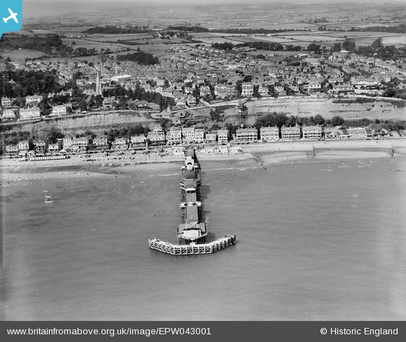
EPW043001 ENGLAND (1933). The pier and town, Shanklin, from the east, 1933
© Copyright OpenStreetMap contributors and licensed by the OpenStreetMap Foundation. 2026. Cartography is licensed as CC BY-SA.
Nearby Images (13)
Details
| Title | [EPW043001] The pier and town, Shanklin, from the east, 1933 |
| Reference | EPW043001 |
| Date | August-1933 |
| Link | |
| Place name | SHANKLIN |
| Parish | SHANKLIN |
| District | |
| Country | ENGLAND |
| Easting / Northing | 458926, 81335 |
| Longitude / Latitude | -1.1667906191275, 50.628149662501 |
| National Grid Reference | SZ589813 |
Pins
Be the first to add a comment to this image!


![[EPW043001] The pier and town, Shanklin, from the east, 1933](http://britainfromabove.org.uk/sites/all/libraries/aerofilms-images/public/100x100/EPW/043/EPW043001.jpg)
![[EPW022924] The Pier, Shanklin, 1928](http://britainfromabove.org.uk/sites/all/libraries/aerofilms-images/public/100x100/EPW/022/EPW022924.jpg)
![[EPW022923] The Pier, Shanklin, 1928](http://britainfromabove.org.uk/sites/all/libraries/aerofilms-images/public/100x100/EPW/022/EPW022923.jpg)
![[EAW022212] The Shanklin Pier and the town, Shanklin, from the north-east, 1949](http://britainfromabove.org.uk/sites/all/libraries/aerofilms-images/public/100x100/EAW/022/EAW022212.jpg)
![[EAW015241] Shanklin Pier and the town, Shanklin, from the south-east, 1948](http://britainfromabove.org.uk/sites/all/libraries/aerofilms-images/public/100x100/EAW/015/EAW015241.jpg)
![[EPW043005] The pier and the town, Shanklin, from the east, 1933](http://britainfromabove.org.uk/sites/all/libraries/aerofilms-images/public/100x100/EPW/043/EPW043005.jpg)
![[EAW038587] Shanklin Pier, the town and the seafront, Shanklin, from the south-east, 1951. This image has been produced from a print.](http://britainfromabove.org.uk/sites/all/libraries/aerofilms-images/public/100x100/EAW/038/EAW038587.jpg)
![[EAW038585] Shanklin Pier, Shanklin, 1951. This image has been produced from a print.](http://britainfromabove.org.uk/sites/all/libraries/aerofilms-images/public/100x100/EAW/038/EAW038585.jpg)
![[EPW022919] The Pier and Esplanade, Shanklin, 1928](http://britainfromabove.org.uk/sites/all/libraries/aerofilms-images/public/100x100/EPW/022/EPW022919.jpg)
![[EAW022213] Shanklin Pier and the town, Shanklin, 1949. This image has been produced from a print.](http://britainfromabove.org.uk/sites/all/libraries/aerofilms-images/public/100x100/EAW/022/EAW022213.jpg)
![[EPW039648] The pier and the town, Shanklin, 1932](http://britainfromabove.org.uk/sites/all/libraries/aerofilms-images/public/100x100/EPW/039/EPW039648.jpg)
![[EPW043003] The Esplanade, East Cliff Promenade and environs, Shanklin, from the south-east, 1933](http://britainfromabove.org.uk/sites/all/libraries/aerofilms-images/public/100x100/EPW/043/EPW043003.jpg)
![[EAW028276] The pier and town, Shanklin, from the south-east, 1950](http://britainfromabove.org.uk/sites/all/libraries/aerofilms-images/public/100x100/EAW/028/EAW028276.jpg)