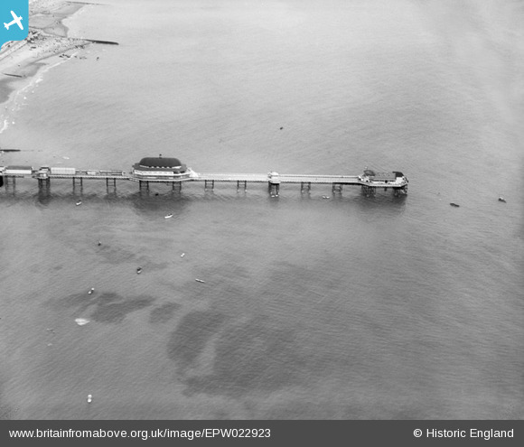
EPW022923 ENGLAND (1928). The Pier, Shanklin, 1928
© Copyright OpenStreetMap contributors and licensed by the OpenStreetMap Foundation. 2026. Cartography is licensed as CC BY-SA.
Nearby Images (17)
Details
| Title | [EPW022923] The Pier, Shanklin, 1928 |
| Reference | EPW022923 |
| Date | August-1928 |
| Link | |
| Place name | SHANKLIN |
| Parish | SHANKLIN |
| District | |
| Country | ENGLAND |
| Easting / Northing | 458869, 81316 |
| Longitude / Latitude | -1.1675995214601, 50.627984557503 |
| National Grid Reference | SZ589813 |
Pins

Adam |
Saturday 25th of July 2015 07:22:42 PM |


![[EPW022923] The Pier, Shanklin, 1928](http://britainfromabove.org.uk/sites/all/libraries/aerofilms-images/public/100x100/EPW/022/EPW022923.jpg)
![[EPW022924] The Pier, Shanklin, 1928](http://britainfromabove.org.uk/sites/all/libraries/aerofilms-images/public/100x100/EPW/022/EPW022924.jpg)
![[EAW022212] The Shanklin Pier and the town, Shanklin, from the north-east, 1949](http://britainfromabove.org.uk/sites/all/libraries/aerofilms-images/public/100x100/EAW/022/EAW022212.jpg)
![[EPW043001] The pier and town, Shanklin, from the east, 1933](http://britainfromabove.org.uk/sites/all/libraries/aerofilms-images/public/100x100/EPW/043/EPW043001.jpg)
![[EAW015241] Shanklin Pier and the town, Shanklin, from the south-east, 1948](http://britainfromabove.org.uk/sites/all/libraries/aerofilms-images/public/100x100/EAW/015/EAW015241.jpg)
![[EAW038585] Shanklin Pier, Shanklin, 1951. This image has been produced from a print.](http://britainfromabove.org.uk/sites/all/libraries/aerofilms-images/public/100x100/EAW/038/EAW038585.jpg)
![[EAW038587] Shanklin Pier, the town and the seafront, Shanklin, from the south-east, 1951. This image has been produced from a print.](http://britainfromabove.org.uk/sites/all/libraries/aerofilms-images/public/100x100/EAW/038/EAW038587.jpg)
![[EPW022919] The Pier and Esplanade, Shanklin, 1928](http://britainfromabove.org.uk/sites/all/libraries/aerofilms-images/public/100x100/EPW/022/EPW022919.jpg)
![[EAW022213] Shanklin Pier and the town, Shanklin, 1949. This image has been produced from a print.](http://britainfromabove.org.uk/sites/all/libraries/aerofilms-images/public/100x100/EAW/022/EAW022213.jpg)
![[EPW043003] The Esplanade, East Cliff Promenade and environs, Shanklin, from the south-east, 1933](http://britainfromabove.org.uk/sites/all/libraries/aerofilms-images/public/100x100/EPW/043/EPW043003.jpg)
![[EPW043005] The pier and the town, Shanklin, from the east, 1933](http://britainfromabove.org.uk/sites/all/libraries/aerofilms-images/public/100x100/EPW/043/EPW043005.jpg)
![[EAW028276] The pier and town, Shanklin, from the south-east, 1950](http://britainfromabove.org.uk/sites/all/libraries/aerofilms-images/public/100x100/EAW/028/EAW028276.jpg)
![[EPW039648] The pier and the town, Shanklin, 1932](http://britainfromabove.org.uk/sites/all/libraries/aerofilms-images/public/100x100/EPW/039/EPW039648.jpg)
![[EPW039646] Hope Beach and the Esplanade, Shanklin, 1932](http://britainfromabove.org.uk/sites/all/libraries/aerofilms-images/public/100x100/EPW/039/EPW039646.jpg)
![[EAW022214] Shanklin Pier and the town, Shanklin, from the east, 1949. This image has been produced from a print.](http://britainfromabove.org.uk/sites/all/libraries/aerofilms-images/public/100x100/EAW/022/EAW022214.jpg)
![[EPW024578] The Royal Spa Hotel and seafront, Shanklin, 1928](http://britainfromabove.org.uk/sites/all/libraries/aerofilms-images/public/100x100/EPW/024/EPW024578.jpg)
![[EPW043004] The Esplanade, East Cliff Promenade and environs, Shanklin, 1933](http://britainfromabove.org.uk/sites/all/libraries/aerofilms-images/public/100x100/EPW/043/EPW043004.jpg)