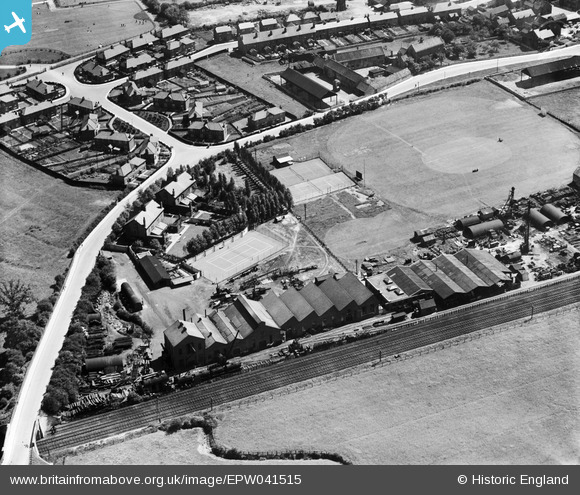
EPW041515 ENGLAND (1933). The Francois Cementation Co Ltd Bentley Works, Bentley, 1933
© Copyright OpenStreetMap contributors and licensed by the OpenStreetMap Foundation. 2026. Cartography is licensed as CC BY-SA.
Nearby Images (36)
Details
| Title | [EPW041515] The Francois Cementation Co Ltd Bentley Works, Bentley, 1933 |
| Reference | EPW041515 |
| Date | June-1933 |
| Link | |
| Place name | BENTLEY |
| Parish | |
| District | |
| Country | ENGLAND |
| Easting / Northing | 456239, 405943 |
| Longitude / Latitude | -1.1511381639628, 53.546863775134 |
| National Grid Reference | SE562059 |
Pins
Be the first to add a comment to this image!


![[EPW041515] The Francois Cementation Co Ltd Bentley Works, Bentley, 1933](http://britainfromabove.org.uk/sites/all/libraries/aerofilms-images/public/100x100/EPW/041/EPW041515.jpg)
![[EAW049791] The Cementation Co Works and the surrounding area, Bentley, 1953](http://britainfromabove.org.uk/sites/all/libraries/aerofilms-images/public/100x100/EAW/049/EAW049791.jpg)
![[EPW041509] The Francois Cementation Co Ltd Bentley Works, Bentley, 1933](http://britainfromabove.org.uk/sites/all/libraries/aerofilms-images/public/100x100/EPW/041/EPW041509.jpg)
![[EPW041512] The Francois Cementation Co Ltd Bentley Works, Bentley, 1933](http://britainfromabove.org.uk/sites/all/libraries/aerofilms-images/public/100x100/EPW/041/EPW041512.jpg)
![[EAW048673] Jossey Lane, the Francois Cementation Co Ltd Bentley Works and environs, Bentley, 1953. This image was marked by Aerofilms Ltd for photo editing.](http://britainfromabove.org.uk/sites/all/libraries/aerofilms-images/public/100x100/EAW/048/EAW048673.jpg)
![[EPW041508] The Francois Cementation Co Ltd Bentley Works, Bentley, 1933](http://britainfromabove.org.uk/sites/all/libraries/aerofilms-images/public/100x100/EPW/041/EPW041508.jpg)
![[EAW048674] Jossey Lane, the Francois Cementation Co Ltd Bentley Works and environs, Bentley, 1953. This image was marked by Aerofilms Ltd for photo editing.](http://britainfromabove.org.uk/sites/all/libraries/aerofilms-images/public/100x100/EAW/048/EAW048674.jpg)
![[EPW041513] The Francois Cementation Co Ltd Bentley Works, Bentley, 1933](http://britainfromabove.org.uk/sites/all/libraries/aerofilms-images/public/100x100/EPW/041/EPW041513.jpg)
![[EPW041511] The Francois Cementation Co Ltd Bentley Works, Bentley, 1933](http://britainfromabove.org.uk/sites/all/libraries/aerofilms-images/public/100x100/EPW/041/EPW041511.jpg)
![[EAW048677] Jossey Lane, the Francois Cementation Co Ltd Bentley Works and environs, Bentley, 1953. This image was marked by Aerofilms Ltd for photo editing.](http://britainfromabove.org.uk/sites/all/libraries/aerofilms-images/public/100x100/EAW/048/EAW048677.jpg)
![[EAW049794] The Cementation Co Works, Park Road and the surrounding area, Bentley, 1953](http://britainfromabove.org.uk/sites/all/libraries/aerofilms-images/public/100x100/EAW/049/EAW049794.jpg)
![[EAW049173] The Cementation Co Works and the surrounding area, Bentley, 1953. This image was marked by Aerofilms Ltd for photo editing.](http://britainfromabove.org.uk/sites/all/libraries/aerofilms-images/public/100x100/EAW/049/EAW049173.jpg)
![[EPW041514] The Francois Cementation Co Ltd Bentley Works, Bentley, 1933](http://britainfromabove.org.uk/sites/all/libraries/aerofilms-images/public/100x100/EPW/041/EPW041514.jpg)
![[EPW042044] Mill Dike Bridge, the Francois Cementation Co Ltd Bentley Works, Bentley and environs, from the north-west, 1933](http://britainfromabove.org.uk/sites/all/libraries/aerofilms-images/public/100x100/EPW/042/EPW042044.jpg)
![[EPW041510] The Francois Cementation Co Ltd Bentley Works, Bentley, 1933](http://britainfromabove.org.uk/sites/all/libraries/aerofilms-images/public/100x100/EPW/041/EPW041510.jpg)
![[EAW049793] The Cementation Co Works and the surrounding area, Bentley, from the north, 1953. This image was marked by Aerofilms Ltd for photo editing.](http://britainfromabove.org.uk/sites/all/libraries/aerofilms-images/public/100x100/EAW/049/EAW049793.jpg)
![[EPW042041] The Francois Cementation Co Ltd Bentley Works, Bentley, from the north-west, 1933](http://britainfromabove.org.uk/sites/all/libraries/aerofilms-images/public/100x100/EPW/042/EPW042041.jpg)
![[EAW049792] The Cementation Co Works and the surrounding area, Bentley, 1953. This image was marked by Aerofilms Ltd for photo editing.](http://britainfromabove.org.uk/sites/all/libraries/aerofilms-images/public/100x100/EAW/049/EAW049792.jpg)
![[EAW049172] The Cementation Co Works and the surrounding area, Bentley, 1953. This image was marked by Aerofilms Ltd for photo editing.](http://britainfromabove.org.uk/sites/all/libraries/aerofilms-images/public/100x100/EAW/049/EAW049172.jpg)
![[EAW048675] Jossey Lane, the Francois Cementation Co Ltd Bentley Works and environs, Bentley, 1953. This image was marked by Aerofilms Ltd for photo editing.](http://britainfromabove.org.uk/sites/all/libraries/aerofilms-images/public/100x100/EAW/048/EAW048675.jpg)
![[EAW046011] The Cementation Co Works and the surrounding area, Bentley, from the north-west, 1952. This image was marked by Aerofilms Ltd for photo editing.](http://britainfromabove.org.uk/sites/all/libraries/aerofilms-images/public/100x100/EAW/046/EAW046011.jpg)
![[EAW046012] The Cementation Co Works and the village, Bentley, 1952. This image was marked by Aerofilms Ltd for photo editing.](http://britainfromabove.org.uk/sites/all/libraries/aerofilms-images/public/100x100/EAW/046/EAW046012.jpg)
![[EAW049174] The Cementation Co Works, Truman Street and the surrounding area, Bentley, 1953. This image was marked by Aerofilms Ltd for photo editing.](http://britainfromabove.org.uk/sites/all/libraries/aerofilms-images/public/100x100/EAW/049/EAW049174.jpg)
![[EAW046010] The Cementation Co Works and the surrounding area, Bentley, from the north-west, 1952](http://britainfromabove.org.uk/sites/all/libraries/aerofilms-images/public/100x100/EAW/046/EAW046010.jpg)
![[EAW046018] The Cementation Co Works, Bentley, 1952](http://britainfromabove.org.uk/sites/all/libraries/aerofilms-images/public/100x100/EAW/046/EAW046018.jpg)
![[EPW042042] The Francois Cementation Co Ltd Bentley Works, Bentley, from the north-east, 1933](http://britainfromabove.org.uk/sites/all/libraries/aerofilms-images/public/100x100/EPW/042/EPW042042.jpg)
![[EAW048678] Jossey Lane, the Francois Cementation Co Ltd Bentley Works and environs, Bentley, 1953. This image was marked by Aerofilms Ltd for photo editing.](http://britainfromabove.org.uk/sites/all/libraries/aerofilms-images/public/100x100/EAW/048/EAW048678.jpg)
![[EAW046016] The Cementation Co Works and Scawthorpe, Bentley, from the east, 1952](http://britainfromabove.org.uk/sites/all/libraries/aerofilms-images/public/100x100/EAW/046/EAW046016.jpg)
![[EAW049795] The Cementation Co Works and the surrounding area, Bentley, from the north-east, 1953. This image was marked by Aerofilms Ltd for photo editing.](http://britainfromabove.org.uk/sites/all/libraries/aerofilms-images/public/100x100/EAW/049/EAW049795.jpg)
![[EPW042043] The Francois Cementation Co Ltd Bentley Works and adjacent recreation ground, Bentley, from the south-east, 1933](http://britainfromabove.org.uk/sites/all/libraries/aerofilms-images/public/100x100/EPW/042/EPW042043.jpg)
![[EAW048676] Jossey Lane, the Francois Cementation Co Ltd Bentley Works and environs, Bentley, 1953](http://britainfromabove.org.uk/sites/all/libraries/aerofilms-images/public/100x100/EAW/048/EAW048676.jpg)
![[EAW049796] The Cementation Co Works and the surrounding area, Bentley, from the north, 1953. This image was marked by Aerofilms Ltd for photo editing.](http://britainfromabove.org.uk/sites/all/libraries/aerofilms-images/public/100x100/EAW/049/EAW049796.jpg)
![[EPW042045] The Francois Cementation Co Ltd Bentley Works and adjacent recreation ground, Bentley, from the north-east, 1933](http://britainfromabove.org.uk/sites/all/libraries/aerofilms-images/public/100x100/EPW/042/EPW042045.jpg)
![[EAW046015] The Cementation Co Works, Bentley, from the east, 1952](http://britainfromabove.org.uk/sites/all/libraries/aerofilms-images/public/100x100/EAW/046/EAW046015.jpg)
![[EAW046013] The Cementation Co Works and the village, Bentley, from the south, 1952. This image was marked by Aerofilms Ltd for photo editing.](http://britainfromabove.org.uk/sites/all/libraries/aerofilms-images/public/100x100/EAW/046/EAW046013.jpg)
![[EAW046017] The Cementation Co Works, Bentley, 1952. This image was marked by Aerofilms Ltd for photo editing.](http://britainfromabove.org.uk/sites/all/libraries/aerofilms-images/public/100x100/EAW/046/EAW046017.jpg)