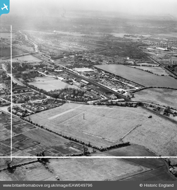
EAW049796 ENGLAND (1953). The Cementation Co Works and the surrounding area, Bentley, from the north, 1953. This image was marked by Aerofilms Ltd for photo editing.
© Copyright OpenStreetMap contributors and licensed by the OpenStreetMap Foundation. 2026. Cartography is licensed as CC BY-SA.
Nearby Images (20)
Details
| Title | [EAW049796] The Cementation Co Works and the surrounding area, Bentley, from the north, 1953. This image was marked by Aerofilms Ltd for photo editing. |
| Reference | EAW049796 |
| Date | 30-May-1953 |
| Link | |
| Place name | BENTLEY |
| Parish | |
| District | |
| Country | ENGLAND |
| Easting / Northing | 456230, 406140 |
| Longitude / Latitude | -1.151238563409, 53.548635454437 |
| National Grid Reference | SE562061 |
Pins
Be the first to add a comment to this image!


![[EAW049796] The Cementation Co Works and the surrounding area, Bentley, from the north, 1953. This image was marked by Aerofilms Ltd for photo editing.](http://britainfromabove.org.uk/sites/all/libraries/aerofilms-images/public/100x100/EAW/049/EAW049796.jpg)
![[EAW049795] The Cementation Co Works and the surrounding area, Bentley, from the north-east, 1953. This image was marked by Aerofilms Ltd for photo editing.](http://britainfromabove.org.uk/sites/all/libraries/aerofilms-images/public/100x100/EAW/049/EAW049795.jpg)
![[EAW049793] The Cementation Co Works and the surrounding area, Bentley, from the north, 1953. This image was marked by Aerofilms Ltd for photo editing.](http://britainfromabove.org.uk/sites/all/libraries/aerofilms-images/public/100x100/EAW/049/EAW049793.jpg)
![[EPW042041] The Francois Cementation Co Ltd Bentley Works, Bentley, from the north-west, 1933](http://britainfromabove.org.uk/sites/all/libraries/aerofilms-images/public/100x100/EPW/042/EPW042041.jpg)
![[EPW041511] The Francois Cementation Co Ltd Bentley Works, Bentley, 1933](http://britainfromabove.org.uk/sites/all/libraries/aerofilms-images/public/100x100/EPW/041/EPW041511.jpg)
![[EPW042044] Mill Dike Bridge, the Francois Cementation Co Ltd Bentley Works, Bentley and environs, from the north-west, 1933](http://britainfromabove.org.uk/sites/all/libraries/aerofilms-images/public/100x100/EPW/042/EPW042044.jpg)
![[EAW048674] Jossey Lane, the Francois Cementation Co Ltd Bentley Works and environs, Bentley, 1953. This image was marked by Aerofilms Ltd for photo editing.](http://britainfromabove.org.uk/sites/all/libraries/aerofilms-images/public/100x100/EAW/048/EAW048674.jpg)
![[EAW049792] The Cementation Co Works and the surrounding area, Bentley, 1953. This image was marked by Aerofilms Ltd for photo editing.](http://britainfromabove.org.uk/sites/all/libraries/aerofilms-images/public/100x100/EAW/049/EAW049792.jpg)
![[EAW049791] The Cementation Co Works and the surrounding area, Bentley, 1953](http://britainfromabove.org.uk/sites/all/libraries/aerofilms-images/public/100x100/EAW/049/EAW049791.jpg)
![[EPW041515] The Francois Cementation Co Ltd Bentley Works, Bentley, 1933](http://britainfromabove.org.uk/sites/all/libraries/aerofilms-images/public/100x100/EPW/041/EPW041515.jpg)
![[EPW041512] The Francois Cementation Co Ltd Bentley Works, Bentley, 1933](http://britainfromabove.org.uk/sites/all/libraries/aerofilms-images/public/100x100/EPW/041/EPW041512.jpg)
![[EAW048673] Jossey Lane, the Francois Cementation Co Ltd Bentley Works and environs, Bentley, 1953. This image was marked by Aerofilms Ltd for photo editing.](http://britainfromabove.org.uk/sites/all/libraries/aerofilms-images/public/100x100/EAW/048/EAW048673.jpg)
![[EAW046011] The Cementation Co Works and the surrounding area, Bentley, from the north-west, 1952. This image was marked by Aerofilms Ltd for photo editing.](http://britainfromabove.org.uk/sites/all/libraries/aerofilms-images/public/100x100/EAW/046/EAW046011.jpg)
![[EPW041509] The Francois Cementation Co Ltd Bentley Works, Bentley, 1933](http://britainfromabove.org.uk/sites/all/libraries/aerofilms-images/public/100x100/EPW/041/EPW041509.jpg)
![[EPW041508] The Francois Cementation Co Ltd Bentley Works, Bentley, 1933](http://britainfromabove.org.uk/sites/all/libraries/aerofilms-images/public/100x100/EPW/041/EPW041508.jpg)
![[EAW046010] The Cementation Co Works and the surrounding area, Bentley, from the north-west, 1952](http://britainfromabove.org.uk/sites/all/libraries/aerofilms-images/public/100x100/EAW/046/EAW046010.jpg)
![[EPW041513] The Francois Cementation Co Ltd Bentley Works, Bentley, 1933](http://britainfromabove.org.uk/sites/all/libraries/aerofilms-images/public/100x100/EPW/041/EPW041513.jpg)
![[EAW048677] Jossey Lane, the Francois Cementation Co Ltd Bentley Works and environs, Bentley, 1953. This image was marked by Aerofilms Ltd for photo editing.](http://britainfromabove.org.uk/sites/all/libraries/aerofilms-images/public/100x100/EAW/048/EAW048677.jpg)
![[EAW049794] The Cementation Co Works, Park Road and the surrounding area, Bentley, 1953](http://britainfromabove.org.uk/sites/all/libraries/aerofilms-images/public/100x100/EAW/049/EAW049794.jpg)
![[EPW042042] The Francois Cementation Co Ltd Bentley Works, Bentley, from the north-east, 1933](http://britainfromabove.org.uk/sites/all/libraries/aerofilms-images/public/100x100/EPW/042/EPW042042.jpg)