
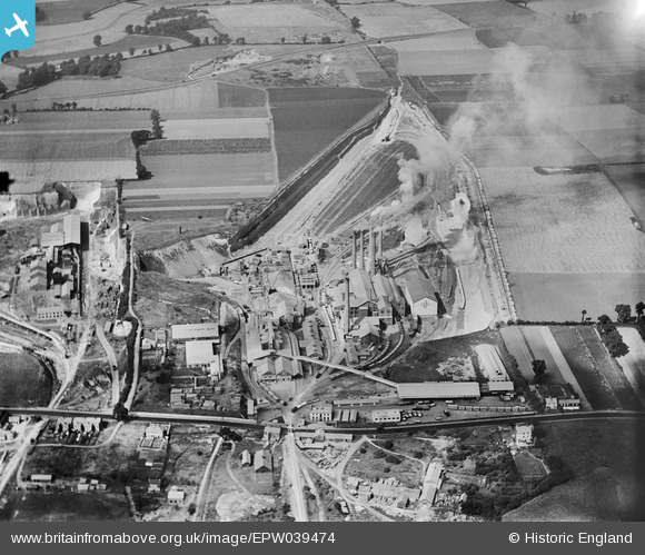
EPW039474 ENGLAND (1932). The Tunnel Cement Works, West Thurrock, 1932
© Copyright OpenStreetMap contributors and licensed by the OpenStreetMap Foundation. 2026. Cartography is licensed as CC BY-SA.
Nearby Images (37)
EPW039474

EPW026644

EPW039473

EPW046465

EPW057052

EPW046463

EPW046467

EPW039470

EPW046468

EPW046462

EPW057047

EPW057044

EPW046466

EPW032826

EPW026640

EPW039471

EPW057053

EPW057043

EPW057054

EPW026639

EPW057046

EPW039475

EPW057050

EPW057049

EPW057048

EPW057055

EPW039476

EPW032825

EPW046464

EPW046469

EPW046470

EPW039472

EPW057051

EPW057045

EAW002393

EAW002390

EAW041087

Details
| Title | [EPW039474] The Tunnel Cement Works, West Thurrock, 1932 |
| Reference | EPW039474 |
| Date | August-1932 |
| Link | |
| Place name | WEST THURROCK |
| Parish | |
| District | |
| Country | ENGLAND |
| Easting / Northing | 557664, 178062 |
| Longitude / Latitude | 0.27070738962037, 51.479025765244 |
| National Grid Reference | TQ577781 |
Pins

Dylan Moore |
Thursday 1st of May 2014 01:08:52 PM | |
|
Dylan Moore |
Thursday 1st of May 2014 01:07:00 PM |
User Comment Contributions
Although in the depths of the Depression, the plant is running flat out, with five kilns making around 1200 tonnes of clinker per day. |
Dylan Moore |
Thursday 1st of May 2014 01:08:09 PM |