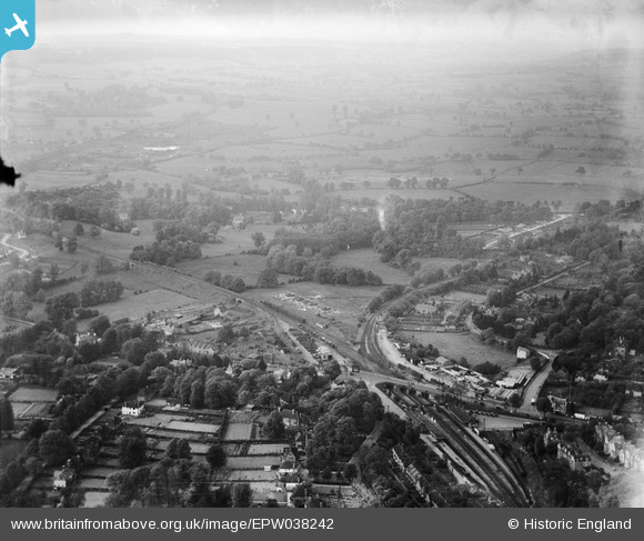
EPW038242 ENGLAND (1932). The area around Sevenoaks Railway Station and construction of new housing at Bosville Drive, Sevenoaks, from the south-west, 1932
© Copyright OpenStreetMap contributors and licensed by the OpenStreetMap Foundation. 2025. Cartography is licensed as CC BY-SA.
Nearby Images (5)
Details
| Title | [EPW038242] The area around Sevenoaks Railway Station and construction of new housing at Bosville Drive, Sevenoaks, from the south-west, 1932 |
| Reference | EPW038242 |
| Date | June-1932 |
| Link | |
| Place name | SEVENOAKS |
| Parish | SEVENOAKS |
| District | |
| Country | ENGLAND |
| Easting / Northing | 552181, 155418 |
| Longitude / Latitude | 0.1821021101245, 51.277045580895 |
| National Grid Reference | TQ522554 |


![[EPW038242] The area around Sevenoaks Railway Station and construction of new housing at Bosville Drive, Sevenoaks, from the south-west, 1932](http://britainfromabove.org.uk/sites/all/libraries/aerofilms-images/public/100x100/EPW/038/EPW038242.jpg)
![[EPW001428] The railway station, Sevenoaks, 1920. This image has been produced from a copy-negative.](http://britainfromabove.org.uk/sites/all/libraries/aerofilms-images/public/100x100/EPW/001/EPW001428.jpg)
![[EPW038237] The area around Sevenoaks Railway Station, Sevenoaks, from the south, 1932](http://britainfromabove.org.uk/sites/all/libraries/aerofilms-images/public/100x100/EPW/038/EPW038237.jpg)
![[EPW038240] The area around Sevenoaks Railway Station, Sevenoaks, from the south-east, 1932](http://britainfromabove.org.uk/sites/all/libraries/aerofilms-images/public/100x100/EPW/038/EPW038240.jpg)
![[EPW038239] The area around Sevenoaks Railway Station and construction of new housing at Bosville Drive, Sevenoaks, from the south-west, 1932](http://britainfromabove.org.uk/sites/all/libraries/aerofilms-images/public/100x100/EPW/038/EPW038239.jpg)
