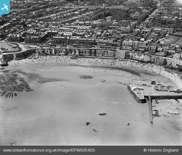
EPW035455 ENGLAND (1931). Viking Bay and the town, Broadstairs, 1931
© Copyright OpenStreetMap contributors and licensed by the OpenStreetMap Foundation. 2026. Cartography is licensed as CC BY-SA.
Nearby Images (27)
Details
| Title | [EPW035455] Viking Bay and the town, Broadstairs, 1931 |
| Reference | EPW035455 |
| Date | May-1931 |
| Link | |
| Place name | BROADSTAIRS |
| Parish | BROADSTAIRS AND ST. PETERS |
| District | |
| Country | ENGLAND |
| Easting / Northing | 639852, 167701 |
| Longitude / Latitude | 1.4454756462599, 51.357158556105 |
| National Grid Reference | TR399677 |
Pins
Be the first to add a comment to this image!


![[EPW035455] Viking Bay and the town, Broadstairs, 1931](http://britainfromabove.org.uk/sites/all/libraries/aerofilms-images/public/100x100/EPW/035/EPW035455.jpg)
![[EPW035459] Viking Bay and the Promenade, Broadstairs, 1931](http://britainfromabove.org.uk/sites/all/libraries/aerofilms-images/public/100x100/EPW/035/EPW035459.jpg)
![[EPW009184] Viking Bay, Broadstairs, 1923](http://britainfromabove.org.uk/sites/all/libraries/aerofilms-images/public/100x100/EPW/009/EPW009184.jpg)
![[EAW024846] Viking Bay, Broadstairs, 1949](http://britainfromabove.org.uk/sites/all/libraries/aerofilms-images/public/100x100/EAW/024/EAW024846.jpg)
![[EAW015846] Viking Bay and environs, Broadstairs, 1948. This image has been produced from a print.](http://britainfromabove.org.uk/sites/all/libraries/aerofilms-images/public/100x100/EAW/015/EAW015846.jpg)
![[EPW035456] Viking Bay, Victoria Gardens and the town, Broadstairs, 1931](http://britainfromabove.org.uk/sites/all/libraries/aerofilms-images/public/100x100/EPW/035/EPW035456.jpg)
![[EAW015847] Victoria Gardens, Viking Bay and environs, Broadstairs, 1948. This image has been produced from a print.](http://britainfromabove.org.uk/sites/all/libraries/aerofilms-images/public/100x100/EAW/015/EAW015847.jpg)
![[EPW009185] Viking Bay, Broadstairs, 1923](http://britainfromabove.org.uk/sites/all/libraries/aerofilms-images/public/100x100/EPW/009/EPW009185.jpg)
![[EAW024845] Viking Bay, Broadstairs, 1949](http://britainfromabove.org.uk/sites/all/libraries/aerofilms-images/public/100x100/EAW/024/EAW024845.jpg)
![[EPW042844] Viking Bay, Broadstairs, 1933](http://britainfromabove.org.uk/sites/all/libraries/aerofilms-images/public/100x100/EPW/042/EPW042844.jpg)
![[EPW000607] Viking Bay, Broadstairs, from the south-east, 1920](http://britainfromabove.org.uk/sites/all/libraries/aerofilms-images/public/100x100/EPW/000/EPW000607.jpg)
![[EPW000344] Victoria Parade, Broadstairs, 1920](http://britainfromabove.org.uk/sites/all/libraries/aerofilms-images/public/100x100/EPW/000/EPW000344.jpg)
![[EAW015844] Victoria Gardens, Viking Bay and environs, Broadstairs, 1948. This image has been produced from a print.](http://britainfromabove.org.uk/sites/all/libraries/aerofilms-images/public/100x100/EAW/015/EAW015844.jpg)
![[EPW035454] Viking Bay and the town, Broadstairs, from the north-east, 1931](http://britainfromabove.org.uk/sites/all/libraries/aerofilms-images/public/100x100/EPW/035/EPW035454.jpg)
![[EPW052894] Viking Bay, York Street and environs, Broadstairs, 1937](http://britainfromabove.org.uk/sites/all/libraries/aerofilms-images/public/100x100/EPW/052/EPW052894.jpg)
![[EPW000118] Broadstairs Pier, Broadstairs, 1920](http://britainfromabove.org.uk/sites/all/libraries/aerofilms-images/public/100x100/EPW/000/EPW000118.jpg)
![[EPW000609] Viking Bay, Broadstairs, from the south-east, 1920](http://britainfromabove.org.uk/sites/all/libraries/aerofilms-images/public/100x100/EPW/000/EPW000609.jpg)
![[EAW015845] Victoria Gardens and environs, Broadstairs, 1948. This image has been produced from a print.](http://britainfromabove.org.uk/sites/all/libraries/aerofilms-images/public/100x100/EAW/015/EAW015845.jpg)
![[EPW000611] York Street and Chandos Terrace, Broadstairs, 1920](http://britainfromabove.org.uk/sites/all/libraries/aerofilms-images/public/100x100/EPW/000/EPW000611.jpg)
![[EPW035457] Viking Bay, Victoria Gardens, Louisa Bay and the town, Broadstairs, 1931](http://britainfromabove.org.uk/sites/all/libraries/aerofilms-images/public/100x100/EPW/035/EPW035457.jpg)
![[EPW042846] Viking Bay and the town, Broadstairs, from the north-east, 1933](http://britainfromabove.org.uk/sites/all/libraries/aerofilms-images/public/100x100/EPW/042/EPW042846.jpg)
![[EAW024847] Short Sunderland flying boat PP117 moored in Viking Bay, Broadstairs, 1949](http://britainfromabove.org.uk/sites/all/libraries/aerofilms-images/public/100x100/EAW/024/EAW024847.jpg)
![[EAW024848] Short Sunderland flying boat PP117 moored in Viking Bay, Broadstairs, 1949](http://britainfromabove.org.uk/sites/all/libraries/aerofilms-images/public/100x100/EAW/024/EAW024848.jpg)
![[EPW000612] Broadstairs and North Foreland, from the south, 1920](http://britainfromabove.org.uk/sites/all/libraries/aerofilms-images/public/100x100/EPW/000/EPW000612.jpg)
![[EPW000610] Viking Bay, Broadstairs, from the north, 1920](http://britainfromabove.org.uk/sites/all/libraries/aerofilms-images/public/100x100/EPW/000/EPW000610.jpg)
![[EPW000119] Holy Trinity Church and environs, Broadstairs, from the south-east, 1920. This image has been produced from a damaged negative.](http://britainfromabove.org.uk/sites/all/libraries/aerofilms-images/public/100x100/EPW/000/EPW000119.jpg)
![[EPW000608] Broadstairs, from the north-west, 1920](http://britainfromabove.org.uk/sites/all/libraries/aerofilms-images/public/100x100/EPW/000/EPW000608.jpg)