
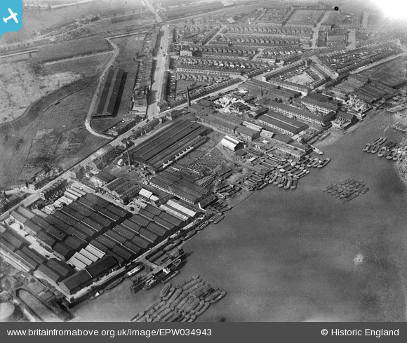
EPW034943 ENGLAND (1931). The Morton's Jam Factory and environs, Cubitt Town, 1931
© Copyright OpenStreetMap contributors and licensed by the OpenStreetMap Foundation. 2026. Cartography is licensed as CC BY-SA.
Nearby Images (19)
EPW034943

EPW034941

EPW034936

EPW034940

EPW034944

EPW034938

EPW034937

EPW034942

EPW034939

EPW026718

EPW026712

EPW026716

EPW026713

EPW026715

EPW026711

EPW026710

EPW026717

EPW026714

EPW026709

Details
| Title | [EPW034943] The Morton's Jam Factory and environs, Cubitt Town, 1931 |
| Reference | EPW034943 |
| Date | 10-April-1931 |
| Link | |
| Place name | CUBITT TOWN |
| Parish | |
| District | |
| Country | ENGLAND |
| Easting / Northing | 538484, 179203 |
| Longitude / Latitude | -0.0048865254415008, 51.49430192237 |
| National Grid Reference | TQ385792 |
Pins

Chaz |
Tuesday 29th of July 2025 02:29:16 PM | |
|
PeterJames |
Thursday 3rd of January 2013 10:59:02 PM | |
|
PeterJames |
Thursday 3rd of January 2013 09:00:21 PM | |
|
PeterJames |
Thursday 3rd of January 2013 08:58:23 PM |