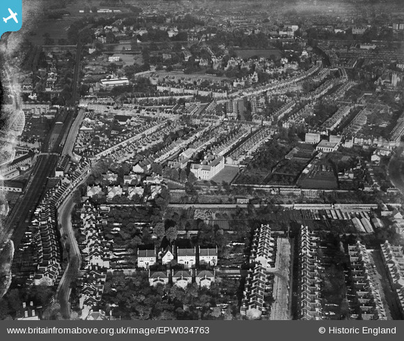
EPW034763 ENGLAND (1930). Housing at St Margarets and Twickenham Riverside, Twickenham, 1930
© Copyright OpenStreetMap contributors and licensed by the OpenStreetMap Foundation. 2026. Cartography is licensed as CC BY-SA.
Nearby Images (9)
Details
| Title | [EPW034763] Housing at St Margarets and Twickenham Riverside, Twickenham, 1930 |
| Reference | EPW034763 |
| Date | 29-October-1930 |
| Link | |
| Place name | TWICKENHAM |
| Parish | |
| District | |
| Country | ENGLAND |
| Easting / Northing | 516738, 173946 |
| Longitude / Latitude | -0.31975590434328, 51.451958289634 |
| National Grid Reference | TQ167739 |
Pins

Wordy |
Saturday 26th of March 2022 07:27:00 PM | |

Drew |
Friday 17th of April 2015 12:26:10 AM | |

Delboy |
Tuesday 16th of September 2014 05:00:59 PM | |

Delboy |
Tuesday 16th of September 2014 05:00:33 PM | |

Joe90 |
Thursday 9th of January 2014 10:18:48 PM | |

Joe90 |
Thursday 9th of January 2014 10:17:32 PM |


![[EPW034763] Housing at St Margarets and Twickenham Riverside, Twickenham, 1930](http://britainfromabove.org.uk/sites/all/libraries/aerofilms-images/public/100x100/EPW/034/EPW034763.jpg)
![[EPW034760] Orleans Park and housing at St Margarets, Twickenham, 1930](http://britainfromabove.org.uk/sites/all/libraries/aerofilms-images/public/100x100/EPW/034/EPW034760.jpg)
![[EPW034758] Housing surrounding Hartington Road and Crown Road, Twickenham, 1930. This image has been produced from a damaged negative.](http://britainfromabove.org.uk/sites/all/libraries/aerofilms-images/public/100x100/EPW/034/EPW034758.jpg)
![[EPW034761] Housing at St Margarets and the Richmond Road Nursery, Twickenham, 1930](http://britainfromabove.org.uk/sites/all/libraries/aerofilms-images/public/100x100/EPW/034/EPW034761.jpg)
![[EPW034755] Orleans Park and housing off Amyand Park Road, Twickenham, 1930. This image has been produced from a damaged negative.](http://britainfromabove.org.uk/sites/all/libraries/aerofilms-images/public/100x100/EPW/034/EPW034755.jpg)
![[EPW034762] Housing off Amyand Park Road and the Richmond Road Nursery, Twickenham, 1930](http://britainfromabove.org.uk/sites/all/libraries/aerofilms-images/public/100x100/EPW/034/EPW034762.jpg)
![[EPW034759] Orleans Park and the Richmond Road Nursery, Twickenham, 1930. This image has been produced from a damaged negative.](http://britainfromabove.org.uk/sites/all/libraries/aerofilms-images/public/100x100/EPW/034/EPW034759.jpg)
![[EPW034757] Orleans Park and housing off Amyand Park Road, Twickenham, 1930. This image has been produced from a damaged negative.](http://britainfromabove.org.uk/sites/all/libraries/aerofilms-images/public/100x100/EPW/034/EPW034757.jpg)
![[EPW034756] Orleans Park and surrounding housing, Twickenham, 1930. This image has been produced from a damaged negative.](http://britainfromabove.org.uk/sites/all/libraries/aerofilms-images/public/100x100/EPW/034/EPW034756.jpg)