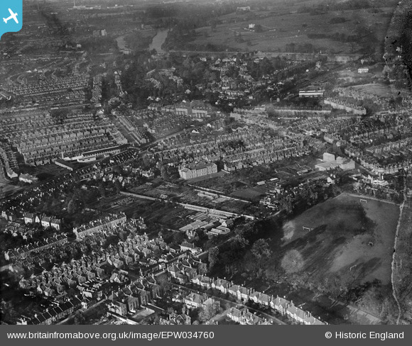
EPW034760 ENGLAND (1930). Orleans Park and housing at St Margarets, Twickenham, 1930
© Copyright OpenStreetMap contributors and licensed by the OpenStreetMap Foundation. 2026. Cartography is licensed as CC BY-SA.
Nearby Images (9)
Details
| Title | [EPW034760] Orleans Park and housing at St Margarets, Twickenham, 1930 |
| Reference | EPW034760 |
| Date | 29-October-1930 |
| Link | |
| Place name | TWICKENHAM |
| Parish | |
| District | |
| Country | ENGLAND |
| Easting / Northing | 516741, 173940 |
| Longitude / Latitude | -0.31971472481707, 51.45190373871 |
| National Grid Reference | TQ167739 |
Pins
User Comment Contributions
Orleans Lodge just visible. No visible boundary. Window and door appear aligned at current front door location. Balcony not present (demolished c1919-1920). Central chimney stack still visible. |

GMH |
Tuesday 28th of January 2014 01:21:43 AM |


![[EPW034760] Orleans Park and housing at St Margarets, Twickenham, 1930](http://britainfromabove.org.uk/sites/all/libraries/aerofilms-images/public/100x100/EPW/034/EPW034760.jpg)
![[EPW034763] Housing at St Margarets and Twickenham Riverside, Twickenham, 1930](http://britainfromabove.org.uk/sites/all/libraries/aerofilms-images/public/100x100/EPW/034/EPW034763.jpg)
![[EPW034758] Housing surrounding Hartington Road and Crown Road, Twickenham, 1930. This image has been produced from a damaged negative.](http://britainfromabove.org.uk/sites/all/libraries/aerofilms-images/public/100x100/EPW/034/EPW034758.jpg)
![[EPW034761] Housing at St Margarets and the Richmond Road Nursery, Twickenham, 1930](http://britainfromabove.org.uk/sites/all/libraries/aerofilms-images/public/100x100/EPW/034/EPW034761.jpg)
![[EPW034755] Orleans Park and housing off Amyand Park Road, Twickenham, 1930. This image has been produced from a damaged negative.](http://britainfromabove.org.uk/sites/all/libraries/aerofilms-images/public/100x100/EPW/034/EPW034755.jpg)
![[EPW034762] Housing off Amyand Park Road and the Richmond Road Nursery, Twickenham, 1930](http://britainfromabove.org.uk/sites/all/libraries/aerofilms-images/public/100x100/EPW/034/EPW034762.jpg)
![[EPW034759] Orleans Park and the Richmond Road Nursery, Twickenham, 1930. This image has been produced from a damaged negative.](http://britainfromabove.org.uk/sites/all/libraries/aerofilms-images/public/100x100/EPW/034/EPW034759.jpg)
![[EPW034757] Orleans Park and housing off Amyand Park Road, Twickenham, 1930. This image has been produced from a damaged negative.](http://britainfromabove.org.uk/sites/all/libraries/aerofilms-images/public/100x100/EPW/034/EPW034757.jpg)
![[EPW034756] Orleans Park and surrounding housing, Twickenham, 1930. This image has been produced from a damaged negative.](http://britainfromabove.org.uk/sites/all/libraries/aerofilms-images/public/100x100/EPW/034/EPW034756.jpg)