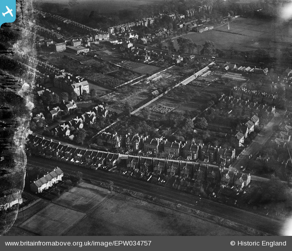
EPW034757 ENGLAND (1930). Orleans Park and housing off Amyand Park Road, Twickenham, 1930. This image has been produced from a damaged negative.
© Copyright OpenStreetMap contributors and licensed by the OpenStreetMap Foundation. 2026. Cartography is licensed as CC BY-SA.
Nearby Images (9)
Details
| Title | [EPW034757] Orleans Park and housing off Amyand Park Road, Twickenham, 1930. This image has been produced from a damaged negative. |
| Reference | EPW034757 |
| Date | 29-October-1930 |
| Link | |
| Place name | TWICKENHAM |
| Parish | |
| District | |
| Country | ENGLAND |
| Easting / Northing | 516611, 173877 |
| Longitude / Latitude | -0.32160575752512, 51.451364243451 |
| National Grid Reference | TQ166739 |
Pins
Be the first to add a comment to this image!
User Comment Contributions
Orleans Lodge visible. Still had central chimney stack. 1919 alterations likely visible. Balcony removed before photograph taken. Note building adjacent to The Crown Inn still standing. |

GMH |
Tuesday 28th of January 2014 01:15:03 AM |


![[EPW034757] Orleans Park and housing off Amyand Park Road, Twickenham, 1930. This image has been produced from a damaged negative.](http://britainfromabove.org.uk/sites/all/libraries/aerofilms-images/public/100x100/EPW/034/EPW034757.jpg)
![[EPW034762] Housing off Amyand Park Road and the Richmond Road Nursery, Twickenham, 1930](http://britainfromabove.org.uk/sites/all/libraries/aerofilms-images/public/100x100/EPW/034/EPW034762.jpg)
![[EPW034761] Housing at St Margarets and the Richmond Road Nursery, Twickenham, 1930](http://britainfromabove.org.uk/sites/all/libraries/aerofilms-images/public/100x100/EPW/034/EPW034761.jpg)
![[EPW034755] Orleans Park and housing off Amyand Park Road, Twickenham, 1930. This image has been produced from a damaged negative.](http://britainfromabove.org.uk/sites/all/libraries/aerofilms-images/public/100x100/EPW/034/EPW034755.jpg)
![[EPW034759] Orleans Park and the Richmond Road Nursery, Twickenham, 1930. This image has been produced from a damaged negative.](http://britainfromabove.org.uk/sites/all/libraries/aerofilms-images/public/100x100/EPW/034/EPW034759.jpg)
![[EPW034760] Orleans Park and housing at St Margarets, Twickenham, 1930](http://britainfromabove.org.uk/sites/all/libraries/aerofilms-images/public/100x100/EPW/034/EPW034760.jpg)
![[EPW034763] Housing at St Margarets and Twickenham Riverside, Twickenham, 1930](http://britainfromabove.org.uk/sites/all/libraries/aerofilms-images/public/100x100/EPW/034/EPW034763.jpg)
![[EPW034756] Orleans Park and surrounding housing, Twickenham, 1930. This image has been produced from a damaged negative.](http://britainfromabove.org.uk/sites/all/libraries/aerofilms-images/public/100x100/EPW/034/EPW034756.jpg)
![[EPW034758] Housing surrounding Hartington Road and Crown Road, Twickenham, 1930. This image has been produced from a damaged negative.](http://britainfromabove.org.uk/sites/all/libraries/aerofilms-images/public/100x100/EPW/034/EPW034758.jpg)