
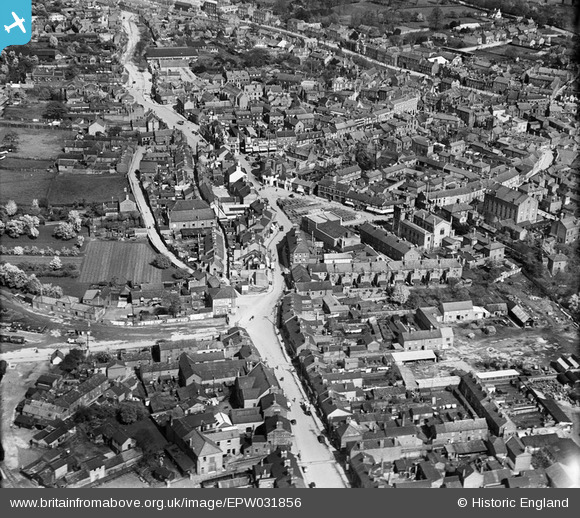
EPW031856 ENGLAND (1930). The cattle market and town centre, Spalding, 1930
© Copyright OpenStreetMap contributors and licensed by the OpenStreetMap Foundation. 2026. Cartography is licensed as CC BY-SA.
Nearby Images (8)
EPW031856

EPW031870

EPW031852

EPW031854

EPW031855

EPW031882

EAW004498

EAW004499

Details
| Title | [EPW031856] The cattle market and town centre, Spalding, 1930 |
| Reference | EPW031856 |
| Date | 7-May-1930 |
| Link | |
| Place name | SPALDING |
| Parish | |
| District | |
| Country | ENGLAND |
| Easting / Northing | 524522, 322664 |
| Longitude / Latitude | -0.15333696049865, 52.78683187832 |
| National Grid Reference | TF245227 |
Pins

Mikelwarb |
Monday 17th of November 2014 06:34:47 PM | |
|
Mikelwarb |
Monday 17th of November 2014 06:33:36 PM | |
|
Mikelwarb |
Monday 17th of November 2014 06:33:00 PM | |
|
Mikelwarb |
Monday 17th of November 2014 06:32:28 PM | |
|
Mikelwarb |
Monday 17th of November 2014 06:31:59 PM | |
|
Mikelwarb |
Monday 17th of November 2014 06:31:36 PM | |
|
Mikelwarb |
Monday 17th of November 2014 06:30:59 PM | |
|
Mikelwarb |
Tuesday 1st of April 2014 10:26:12 PM | |
|
Mikelwarb |
Tuesday 1st of April 2014 10:24:49 PM | |
|
Mikelwarb |
Tuesday 1st of April 2014 10:23:56 PM | |
|
Mikelwarb |
Tuesday 1st of April 2014 10:23:14 PM | |
|
Mikelwarb |
Tuesday 1st of April 2014 10:20:52 PM |
User Comment Contributions
Demolished to build a hideous GPO telephone exchange |
Mikelwarb |
Tuesday 1st of April 2014 10:22:09 PM |