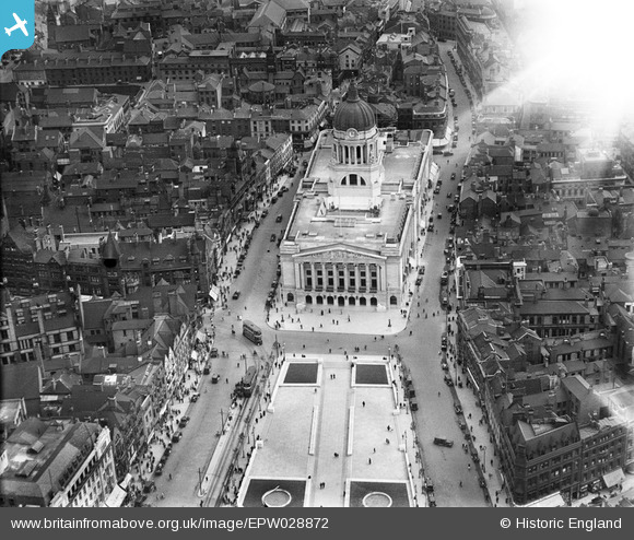
EPW028872 ENGLAND (1929). The Council House and environs, Nottingham, 1929. This image has been affected by flare.
© Copyright OpenStreetMap contributors and licensed by the OpenStreetMap Foundation. 2026. Cartography is licensed as CC BY-SA.
Nearby Images (32)
Details
| Title | [EPW028872] The Council House and environs, Nottingham, 1929. This image has been affected by flare. |
| Reference | EPW028872 |
| Date | August-1929 |
| Link | |
| Place name | NOTTINGHAM |
| Parish | |
| District | |
| Country | ENGLAND |
| Easting / Northing | 457255, 339903 |
| Longitude / Latitude | -1.1476851053909, 52.953131623935 |
| National Grid Reference | SK573399 |
Pins

longshot |
Sunday 23rd of December 2012 12:33:56 PM |


![[EPW028872] The Council House and environs, Nottingham, 1929. This image has been affected by flare.](http://britainfromabove.org.uk/sites/all/libraries/aerofilms-images/public/100x100/EPW/028/EPW028872.jpg)
![[EAW025941] The city centre, Nottingham, 1949. This image has been produced from a damaged negative.](http://britainfromabove.org.uk/sites/all/libraries/aerofilms-images/public/100x100/EAW/025/EAW025941.jpg)
![[EPW054996] The Council House and city centre, Nottingham, 1937](http://britainfromabove.org.uk/sites/all/libraries/aerofilms-images/public/100x100/EPW/054/EPW054996.jpg)
![[EPW038634] The Council House and Market Place, Nottingham, 1932](http://britainfromabove.org.uk/sites/all/libraries/aerofilms-images/public/100x100/EPW/038/EPW038634.jpg)
![[EPW028870] The Council House and Old Market Square, Nottingham, 1929](http://britainfromabove.org.uk/sites/all/libraries/aerofilms-images/public/100x100/EPW/028/EPW028870.jpg)
![[EPW028000] The Council House and environs, Nottingham, 1929](http://britainfromabove.org.uk/sites/all/libraries/aerofilms-images/public/100x100/EPW/028/EPW028000.jpg)
![[EPW027998] The Council House, Nottingham, 1929](http://britainfromabove.org.uk/sites/all/libraries/aerofilms-images/public/100x100/EPW/027/EPW027998.jpg)
![[EAW050486] The Old Market Square, Council House and environs, Nottingham, 1953](http://britainfromabove.org.uk/sites/all/libraries/aerofilms-images/public/100x100/EAW/050/EAW050486.jpg)
![[EPW021793] The Town Hall and Market Place, Nottingham, 1928](http://britainfromabove.org.uk/sites/all/libraries/aerofilms-images/public/100x100/EPW/021/EPW021793.jpg)
![[EPW028002] The Council House and environs, Nottingham, 1929](http://britainfromabove.org.uk/sites/all/libraries/aerofilms-images/public/100x100/EPW/028/EPW028002.jpg)
![[EPW027999] The Council House and environs, Nottingham, 1929](http://britainfromabove.org.uk/sites/all/libraries/aerofilms-images/public/100x100/EPW/027/EPW027999.jpg)
![[EAW042516] The city centre, Nottingham, 1952](http://britainfromabove.org.uk/sites/all/libraries/aerofilms-images/public/100x100/EAW/042/EAW042516.jpg)
![[EPW028869] The Council House and Old Market Square, Nottingham, 1929](http://britainfromabove.org.uk/sites/all/libraries/aerofilms-images/public/100x100/EPW/028/EPW028869.jpg)
![[EPW028871] The Council House and environs, Nottingham, 1929](http://britainfromabove.org.uk/sites/all/libraries/aerofilms-images/public/100x100/EPW/028/EPW028871.jpg)
![[EPW054993] The city centre, Nottingham, 1937. This image has been produced from a copy-negative.](http://britainfromabove.org.uk/sites/all/libraries/aerofilms-images/public/100x100/EPW/054/EPW054993.jpg)
![[EPW028001] The Council House and environs, Nottingham, 1929](http://britainfromabove.org.uk/sites/all/libraries/aerofilms-images/public/100x100/EPW/028/EPW028001.jpg)
![[EAW042517] The city centre, Nottingham, 1952](http://britainfromabove.org.uk/sites/all/libraries/aerofilms-images/public/100x100/EAW/042/EAW042517.jpg)
![[EPW028873] The Council House and environs, Nottingham, 1929](http://britainfromabove.org.uk/sites/all/libraries/aerofilms-images/public/100x100/EPW/028/EPW028873.jpg)
![[EAW025940] The city centre, Nottingham, 1949. This image has been produced from a print.](http://britainfromabove.org.uk/sites/all/libraries/aerofilms-images/public/100x100/EAW/025/EAW025940.jpg)
![[EAW042515] The city centre, Nottingham, 1952](http://britainfromabove.org.uk/sites/all/libraries/aerofilms-images/public/100x100/EAW/042/EAW042515.jpg)
![[EPW047469] The Council House and the city centre, Nottingham, 1935](http://britainfromabove.org.uk/sites/all/libraries/aerofilms-images/public/100x100/EPW/047/EPW047469.jpg)
![[EPR000151] The Council House and city centre, Nottingham, 1934](http://britainfromabove.org.uk/sites/all/libraries/aerofilms-images/public/100x100/EPR/000/EPR000151.jpg)
![[EAW021699] The Council House and the city centre, Nottingham, from the south-west, 1949. This image has been produced from a print.](http://britainfromabove.org.uk/sites/all/libraries/aerofilms-images/public/100x100/EAW/021/EAW021699.jpg)
![[EPW013014] The Market Place, Wheeler Gate and surroundings, Nottingham, 1925](http://britainfromabove.org.uk/sites/all/libraries/aerofilms-images/public/100x100/EPW/013/EPW013014.jpg)
![[EAW021697] The Council House and the city centre, Nottingham, 1949. This image has been produced from a print.](http://britainfromabove.org.uk/sites/all/libraries/aerofilms-images/public/100x100/EAW/021/EAW021697.jpg)
![[EPW054997] The Council House and city centre, Nottingham, 1937](http://britainfromabove.org.uk/sites/all/libraries/aerofilms-images/public/100x100/EPW/054/EPW054997.jpg)
![[EPW013018] The city centre, Nottingham, 1925](http://britainfromabove.org.uk/sites/all/libraries/aerofilms-images/public/100x100/EPW/013/EPW013018.jpg)
![[EPW047468] The Council House and the city centre, Nottingham, from the south-east, 1935](http://britainfromabove.org.uk/sites/all/libraries/aerofilms-images/public/100x100/EPW/047/EPW047468.jpg)
![[EPW054989] The Council House and city centre, Nottingham, 1937](http://britainfromabove.org.uk/sites/all/libraries/aerofilms-images/public/100x100/EPW/054/EPW054989.jpg)
![[EAW021698] Long Row and the city centre, Nottingham, 1949. This image has been produced from a print.](http://britainfromabove.org.uk/sites/all/libraries/aerofilms-images/public/100x100/EAW/021/EAW021698.jpg)
![[EAW050484] The city centre between the Castle and the Council House, Nottingham, 1953](http://britainfromabove.org.uk/sites/all/libraries/aerofilms-images/public/100x100/EAW/050/EAW050484.jpg)
![[EPW054995] The city centre, Nottingham, 1937](http://britainfromabove.org.uk/sites/all/libraries/aerofilms-images/public/100x100/EPW/054/EPW054995.jpg)