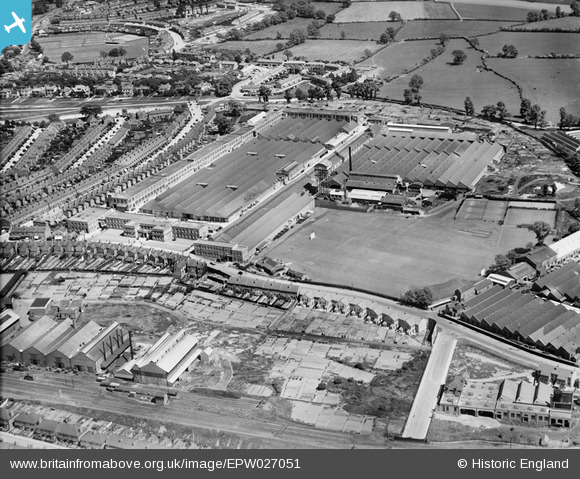
EPW027051 ENGLAND (1929). The Humber Motor Car Works, Coventry, 1929
© Copyright OpenStreetMap contributors and licensed by the OpenStreetMap Foundation. 2026. Cartography is licensed as CC BY-SA.
Nearby Images (28)
Details
| Title | [EPW027051] The Humber Motor Car Works, Coventry, 1929 |
| Reference | EPW027051 |
| Date | 31-May-1929 |
| Link | |
| Place name | COVENTRY |
| Parish | |
| District | |
| Country | ENGLAND |
| Easting / Northing | 435065, 278274 |
| Longitude / Latitude | -1.4845558320948, 52.400975708797 |
| National Grid Reference | SP351783 |
Pins

Darren |
Saturday 20th of April 2019 02:50:30 AM | |

oliver.crofts |
Thursday 19th of July 2018 09:31:53 PM | |

Class31 |
Tuesday 12th of March 2013 09:42:55 AM | |

Class31 |
Tuesday 12th of March 2013 09:42:21 AM | |

Class31 |
Tuesday 12th of March 2013 09:41:46 AM | |

Class31 |
Tuesday 12th of March 2013 09:41:02 AM | |

Class31 |
Tuesday 12th of March 2013 09:40:40 AM |


![[EPW027051] The Humber Motor Car Works, Coventry, 1929](http://britainfromabove.org.uk/sites/all/libraries/aerofilms-images/public/100x100/EPW/027/EPW027051.jpg)
![[EPW027049] The Humber Motor Car Works, Coventry, 1929](http://britainfromabove.org.uk/sites/all/libraries/aerofilms-images/public/100x100/EPW/027/EPW027049.jpg)
![[EPW010515] The Humber Works, Coventry, 1924](http://britainfromabove.org.uk/sites/all/libraries/aerofilms-images/public/100x100/EPW/010/EPW010515.jpg)
![[EPW027054] The Humber Motor Car Works, Coventry, 1929](http://britainfromabove.org.uk/sites/all/libraries/aerofilms-images/public/100x100/EPW/027/EPW027054.jpg)
![[EPW027053] The Humber Motor Car Works, Coventry, 1929](http://britainfromabove.org.uk/sites/all/libraries/aerofilms-images/public/100x100/EPW/027/EPW027053.jpg)
![[EPW027055] The Humber Motor Car Works, Coventry, 1929](http://britainfromabove.org.uk/sites/all/libraries/aerofilms-images/public/100x100/EPW/027/EPW027055.jpg)
![[EPW027050] The Humber Motor Car Works, Coventry, 1929](http://britainfromabove.org.uk/sites/all/libraries/aerofilms-images/public/100x100/EPW/027/EPW027050.jpg)
![[EPW027056] The Humber Motor Car Works, Coventry, 1929](http://britainfromabove.org.uk/sites/all/libraries/aerofilms-images/public/100x100/EPW/027/EPW027056.jpg)
![[EPW027052] The Humber Motor Car Works, Coventry, 1929](http://britainfromabove.org.uk/sites/all/libraries/aerofilms-images/public/100x100/EPW/027/EPW027052.jpg)
![[EPW010574] The Humber Motor Car Works, Coventry, 1924. This image has been produced from a print.](http://britainfromabove.org.uk/sites/all/libraries/aerofilms-images/public/100x100/EPW/010/EPW010574.jpg)
![[EPW010514] The Humber Works, Coventry, 1924](http://britainfromabove.org.uk/sites/all/libraries/aerofilms-images/public/100x100/EPW/010/EPW010514.jpg)
![[EAW030222] Thomas Smith's Stamping Works on Humber Avenue and environs, Coventry, 1950. This image was marked by Aerofilms Ltd for photo editing.](http://britainfromabove.org.uk/sites/all/libraries/aerofilms-images/public/100x100/EAW/030/EAW030222.jpg)
![[EPW061108] The Humber Motor Car Works, Lower Stoke, 1939](http://britainfromabove.org.uk/sites/all/libraries/aerofilms-images/public/100x100/EPW/061/EPW061108.jpg)
![[EAW030217] Thomas Smith's Stamping Works on Humber Avenue and environs, Coventry, 1950. This image was marked by Aerofilms Ltd for photo editing.](http://britainfromabove.org.uk/sites/all/libraries/aerofilms-images/public/100x100/EAW/030/EAW030217.jpg)
![[EPW061110] Gosford Green Goods Station, Humber Road and environs, Gosford Green, 1939](http://britainfromabove.org.uk/sites/all/libraries/aerofilms-images/public/100x100/EPW/061/EPW061110.jpg)
![[EAW030220] Thomas Smith's Stamping Works on Humber Avenue and environs, Coventry, 1950. This image was marked by Aerofilms Ltd for photo editing.](http://britainfromabove.org.uk/sites/all/libraries/aerofilms-images/public/100x100/EAW/030/EAW030220.jpg)
![[EAW030221] Humber Road, Ribble Road, Thomas Smith's Stamping Works on Humber Avenue and environs, Coventry, 1950. This image was marked by Aerofilms Ltd for photo editing.](http://britainfromabove.org.uk/sites/all/libraries/aerofilms-images/public/100x100/EAW/030/EAW030221.jpg)
![[EAW030218] Humber Road, Ribble Road, Thomas Smith's Stamping Works on Humber Avenue and environs, Coventry, 1950. This image was marked by Aerofilms Ltd for photo editing.](http://britainfromabove.org.uk/sites/all/libraries/aerofilms-images/public/100x100/EAW/030/EAW030218.jpg)
![[EAW030219] Thomas Smith's Stamping Works on Humber Avenue and environs, Coventry, 1950. This image was marked by Aerofilms Ltd for photo editing.](http://britainfromabove.org.uk/sites/all/libraries/aerofilms-images/public/100x100/EAW/030/EAW030219.jpg)
![[EAW030223] Ribble Road, Thomas Smith's Stamping Works on Humber Avenue and environs, Coventry, 1950. This image was marked by Aerofilms Ltd for photo editing.](http://britainfromabove.org.uk/sites/all/libraries/aerofilms-images/public/100x100/EAW/030/EAW030223.jpg)
![[EAW030216] Thomas Smith's Stamping Works on Humber Avenue, Coventry, 1950. This image was marked by Aerofilms Ltd for photo editing.](http://britainfromabove.org.uk/sites/all/libraries/aerofilms-images/public/100x100/EAW/030/EAW030216.jpg)
![[EPW027044] The Hillman Motor Car Works and the British Oxygen Company Ltd Works, Coventry, 1929](http://britainfromabove.org.uk/sites/all/libraries/aerofilms-images/public/100x100/EPW/027/EPW027044.jpg)
![[EAW030214] Thomas Smith's Stamping Works on Humber Avenue, Coventry, 1950. This image was marked by Aerofilms Ltd for photo editing.](http://britainfromabove.org.uk/sites/all/libraries/aerofilms-images/public/100x100/EAW/030/EAW030214.jpg)
![[EPW027046] The Hillman Motor Car Works and the Humber Motor Car Works, Coventry, 1929](http://britainfromabove.org.uk/sites/all/libraries/aerofilms-images/public/100x100/EPW/027/EPW027046.jpg)
![[EPW021026] Hillman Motor Car Works, Coventry, 1928](http://britainfromabove.org.uk/sites/all/libraries/aerofilms-images/public/100x100/EPW/021/EPW021026.jpg)
![[EPW021025] Hillman Motor Car Works, Coventry, 1928](http://britainfromabove.org.uk/sites/all/libraries/aerofilms-images/public/100x100/EPW/021/EPW021025.jpg)
![[EAW030215] Thomas Smith's Stamping Works on Humber Avenue and environs, Coventry, 1950. This image was marked by Aerofilms Ltd for photo editing.](http://britainfromabove.org.uk/sites/all/libraries/aerofilms-images/public/100x100/EAW/030/EAW030215.jpg)
![[EPW021022] Hillman Motor Car Works, Coventry, 1928](http://britainfromabove.org.uk/sites/all/libraries/aerofilms-images/public/100x100/EPW/021/EPW021022.jpg)