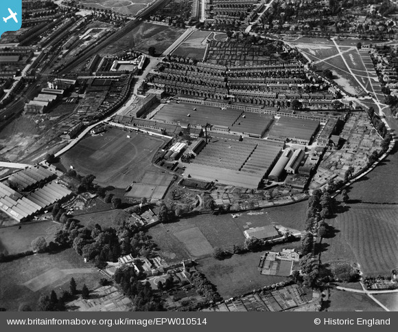
EPW010514 ENGLAND (1924). The Humber Works, Coventry, 1924
© Copyright OpenStreetMap contributors and licensed by the OpenStreetMap Foundation. 2026. Cartography is licensed as CC BY-SA.
Nearby Images (20)
Details
| Title | [EPW010514] The Humber Works, Coventry, 1924 |
| Reference | EPW010514 |
| Date | 28-May-1924 |
| Link | |
| Place name | COVENTRY |
| Parish | |
| District | |
| Country | ENGLAND |
| Easting / Northing | 435177, 278205 |
| Longitude / Latitude | -1.4829167932613, 52.400348157223 |
| National Grid Reference | SP352782 |
Pins

JonB |
Wednesday 24th of July 2013 07:00:29 PM | |

JonB |
Wednesday 24th of July 2013 06:58:23 PM | |

JonB |
Wednesday 24th of July 2013 06:49:05 PM |
User Comment Contributions

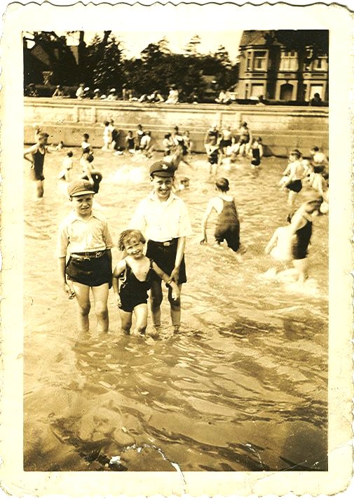
Stoke Green Paddling Pool. My Uncle, George Lester 1927-2013 on left |

Derrickarthur |
Tuesday 18th of March 2014 11:11:50 PM |


![[EPW010514] The Humber Works, Coventry, 1924](http://britainfromabove.org.uk/sites/all/libraries/aerofilms-images/public/100x100/EPW/010/EPW010514.jpg)
![[EPW010574] The Humber Motor Car Works, Coventry, 1924. This image has been produced from a print.](http://britainfromabove.org.uk/sites/all/libraries/aerofilms-images/public/100x100/EPW/010/EPW010574.jpg)
![[EPW061108] The Humber Motor Car Works, Lower Stoke, 1939](http://britainfromabove.org.uk/sites/all/libraries/aerofilms-images/public/100x100/EPW/061/EPW061108.jpg)
![[EPW027053] The Humber Motor Car Works, Coventry, 1929](http://britainfromabove.org.uk/sites/all/libraries/aerofilms-images/public/100x100/EPW/027/EPW027053.jpg)
![[EPW027054] The Humber Motor Car Works, Coventry, 1929](http://britainfromabove.org.uk/sites/all/libraries/aerofilms-images/public/100x100/EPW/027/EPW027054.jpg)
![[EPW027051] The Humber Motor Car Works, Coventry, 1929](http://britainfromabove.org.uk/sites/all/libraries/aerofilms-images/public/100x100/EPW/027/EPW027051.jpg)
![[EPW027049] The Humber Motor Car Works, Coventry, 1929](http://britainfromabove.org.uk/sites/all/libraries/aerofilms-images/public/100x100/EPW/027/EPW027049.jpg)
![[EPW010515] The Humber Works, Coventry, 1924](http://britainfromabove.org.uk/sites/all/libraries/aerofilms-images/public/100x100/EPW/010/EPW010515.jpg)
![[EPW027055] The Humber Motor Car Works, Coventry, 1929](http://britainfromabove.org.uk/sites/all/libraries/aerofilms-images/public/100x100/EPW/027/EPW027055.jpg)
![[EPW027056] The Humber Motor Car Works, Coventry, 1929](http://britainfromabove.org.uk/sites/all/libraries/aerofilms-images/public/100x100/EPW/027/EPW027056.jpg)
![[EPW027050] The Humber Motor Car Works, Coventry, 1929](http://britainfromabove.org.uk/sites/all/libraries/aerofilms-images/public/100x100/EPW/027/EPW027050.jpg)
![[EPW027052] The Humber Motor Car Works, Coventry, 1929](http://britainfromabove.org.uk/sites/all/libraries/aerofilms-images/public/100x100/EPW/027/EPW027052.jpg)
![[EPW021025] Hillman Motor Car Works, Coventry, 1928](http://britainfromabove.org.uk/sites/all/libraries/aerofilms-images/public/100x100/EPW/021/EPW021025.jpg)
![[EAW030222] Thomas Smith's Stamping Works on Humber Avenue and environs, Coventry, 1950. This image was marked by Aerofilms Ltd for photo editing.](http://britainfromabove.org.uk/sites/all/libraries/aerofilms-images/public/100x100/EAW/030/EAW030222.jpg)
![[EPW021024] Hillman Motor Car Works, Coventry, 1928](http://britainfromabove.org.uk/sites/all/libraries/aerofilms-images/public/100x100/EPW/021/EPW021024.jpg)
![[EPW027044] The Hillman Motor Car Works and the British Oxygen Company Ltd Works, Coventry, 1929](http://britainfromabove.org.uk/sites/all/libraries/aerofilms-images/public/100x100/EPW/027/EPW027044.jpg)
![[EPW021022] Hillman Motor Car Works, Coventry, 1928](http://britainfromabove.org.uk/sites/all/libraries/aerofilms-images/public/100x100/EPW/021/EPW021022.jpg)
![[EPW021023] Hillman Motor Car Works, Coventry, 1928](http://britainfromabove.org.uk/sites/all/libraries/aerofilms-images/public/100x100/EPW/021/EPW021023.jpg)
![[EPW027047] The Hillman Motor Car Works and Humber Road, Coventry, 1929](http://britainfromabove.org.uk/sites/all/libraries/aerofilms-images/public/100x100/EPW/027/EPW027047.jpg)
![[EPW021021] Hillman Motor Car Works, Coventry, 1928](http://britainfromabove.org.uk/sites/all/libraries/aerofilms-images/public/100x100/EPW/021/EPW021021.jpg)


