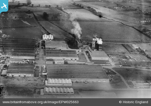
EPW025663 ENGLAND (1929). Various Works buildings on the Slough Trading Estate, Slough, 1929
© Copyright OpenStreetMap contributors and licensed by the OpenStreetMap Foundation. 2026. Cartography is licensed as CC BY-SA.
Nearby Images (26)
Details
| Title | [EPW025663] Various Works buildings on the Slough Trading Estate, Slough, 1929 |
| Reference | EPW025663 |
| Date | 26-January-1929 |
| Link | |
| Place name | SLOUGH |
| Parish | |
| District | |
| Country | ENGLAND |
| Easting / Northing | 495267, 181426 |
| Longitude / Latitude | -0.6266691957345, 51.523223935512 |
| National Grid Reference | SU953814 |


![[EPW025663] Various Works buildings on the Slough Trading Estate, Slough, 1929](http://britainfromabove.org.uk/sites/all/libraries/aerofilms-images/public/100x100/EPW/025/EPW025663.jpg)
![[EPW000025] Slough Motor Works, Slough, 1920](http://britainfromabove.org.uk/sites/all/libraries/aerofilms-images/public/100x100/EPW/000/EPW000025.jpg)
![[EAW015084] The Slough Trading Estate, Slough, 1948](http://britainfromabove.org.uk/sites/all/libraries/aerofilms-images/public/100x100/EAW/015/EAW015084.jpg)
![[EPW015616] The Citroen Motor Works and Slough Trading Estate, Slough, 1926](http://britainfromabove.org.uk/sites/all/libraries/aerofilms-images/public/100x100/EPW/015/EPW015616.jpg)
![[EPW025672] The Estate Offices and various Works buildings on the Slough Trading Estate, Slough, 1929. This image has been produced from a damaged negative.](http://britainfromabove.org.uk/sites/all/libraries/aerofilms-images/public/100x100/EPW/025/EPW025672.jpg)
![[EPW015614] The Citroen Motor Works and Slough Trading Estate, Slough, 1926](http://britainfromabove.org.uk/sites/all/libraries/aerofilms-images/public/100x100/EPW/015/EPW015614.jpg)
![[EPW056617] The Slough Trading Estate, Slough, 1938](http://britainfromabove.org.uk/sites/all/libraries/aerofilms-images/public/100x100/EPW/056/EPW056617.jpg)
![[EPW015613] The Citroen Motor Works and Slough Trading Estate, Slough, 1926](http://britainfromabove.org.uk/sites/all/libraries/aerofilms-images/public/100x100/EPW/015/EPW015613.jpg)
![[EPW056619] Part of the Slough Trading Estate on Fairlie Road, Slough, 1938. This image has been produced from a copy-negative.](http://britainfromabove.org.uk/sites/all/libraries/aerofilms-images/public/100x100/EPW/056/EPW056619.jpg)
![[EPW000021] Slough Motor Works, Slough, 1920](http://britainfromabove.org.uk/sites/all/libraries/aerofilms-images/public/100x100/EPW/000/EPW000021.jpg)
![[EPW056618] The Slough Trading Estate, Slough, 1938. This image has been produced from a copy-negative.](http://britainfromabove.org.uk/sites/all/libraries/aerofilms-images/public/100x100/EPW/056/EPW056618.jpg)
![[EPW025662] The Citroen Motor Works and other factories on the Slough Trading Estate, Slough, 1929](http://britainfromabove.org.uk/sites/all/libraries/aerofilms-images/public/100x100/EPW/025/EPW025662.jpg)
![[EPW025666] The Citroen Motor Works and other factories on the Slough Trading Estate, Slough, 1929](http://britainfromabove.org.uk/sites/all/libraries/aerofilms-images/public/100x100/EPW/025/EPW025666.jpg)
![[EPW025661] The Estate Offices and various Works buildings including BeZeBe Honey and Gillette on the Slough Trading Estate, Slough, 1929](http://britainfromabove.org.uk/sites/all/libraries/aerofilms-images/public/100x100/EPW/025/EPW025661.jpg)
![[EPW025667] The Citroen Motor Works and other factories on the Slough Trading Estate, Slough, 1929](http://britainfromabove.org.uk/sites/all/libraries/aerofilms-images/public/100x100/EPW/025/EPW025667.jpg)
![[EAW015085] The Slough Trading Estate, Slough, 1948](http://britainfromabove.org.uk/sites/all/libraries/aerofilms-images/public/100x100/EAW/015/EAW015085.jpg)
![[EPW025646] D.M. Davies and Sons Multiple Woodwork Manufacturers on the Slough Trading Estate, Slough, 1929](http://britainfromabove.org.uk/sites/all/libraries/aerofilms-images/public/100x100/EPW/025/EPW025646.jpg)
![[EPW025649] D.M. Davies and Sons Multiple Woodwork Manufacturers on the Slough Trading Estate, Slough, 1929](http://britainfromabove.org.uk/sites/all/libraries/aerofilms-images/public/100x100/EPW/025/EPW025649.jpg)
![[EPW025651] D.M. Davies and Sons Multiple Woodwork Manufacturers on the Slough Trading Estate, Slough, 1929](http://britainfromabove.org.uk/sites/all/libraries/aerofilms-images/public/100x100/EPW/025/EPW025651.jpg)
![[EPW025648] D.M. Davies and Sons Multiple Woodwork Manufacturers on the Slough Trading Estate, Slough, 1929. This image has been produced from a damaged negative.](http://britainfromabove.org.uk/sites/all/libraries/aerofilms-images/public/100x100/EPW/025/EPW025648.jpg)
![[EPW025650] D.M. Davies and Sons Multiple Woodwork Manufacturers on the Slough Trading Estate, Slough, 1929](http://britainfromabove.org.uk/sites/all/libraries/aerofilms-images/public/100x100/EPW/025/EPW025650.jpg)
![[EPW000027] Slough Motor Works, Slough, 1920](http://britainfromabove.org.uk/sites/all/libraries/aerofilms-images/public/100x100/EPW/000/EPW000027.jpg)
![[EPW025647] D.M. Davies and Sons Multiple Woodwork Manufacturers on the Slough Trading Estate, Slough, 1929](http://britainfromabove.org.uk/sites/all/libraries/aerofilms-images/public/100x100/EPW/025/EPW025647.jpg)
![[EPW025653] D.M. Davies and Sons Multiple Woodwork Manufacturers on the Slough Trading Estate, Slough, 1929. This image has been produced from a damaged negative.](http://britainfromabove.org.uk/sites/all/libraries/aerofilms-images/public/100x100/EPW/025/EPW025653.jpg)
![[EPW025652] D.M. Davies and Sons Multiple Woodwork Manufacturers on the Slough Trading Estate, Slough, 1929](http://britainfromabove.org.uk/sites/all/libraries/aerofilms-images/public/100x100/EPW/025/EPW025652.jpg)
![[EPW025654] D.M. Davies and Sons Multiple Woodwork Manufacturers on the Slough Trading Estate, Slough, 1929](http://britainfromabove.org.uk/sites/all/libraries/aerofilms-images/public/100x100/EPW/025/EPW025654.jpg)
