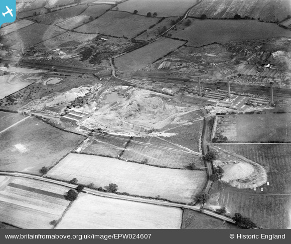
EPW024607 ENGLAND (1928). The Stoneware Limited Works and clay pits, Whateley, 1928
© Copyright OpenStreetMap contributors and licensed by the OpenStreetMap Foundation. 2026. Cartography is licensed as CC BY-SA.
Nearby Images (25)
Details
| Title | [EPW024607] The Stoneware Limited Works and clay pits, Whateley, 1928 |
| Reference | EPW024607 |
| Date | September-1928 |
| Link | |
| Place name | WHATELEY |
| Parish | KINGSBURY |
| District | |
| Country | ENGLAND |
| Easting / Northing | 421630, 299290 |
| Longitude / Latitude | -1.680675777747, 52.590623337371 |
| National Grid Reference | SP216993 |
Pins
Be the first to add a comment to this image!


![[EPW024607] The Stoneware Limited Works and clay pits, Whateley, 1928](http://britainfromabove.org.uk/sites/all/libraries/aerofilms-images/public/100x100/EPW/024/EPW024607.jpg)
![[EPW024611] The Stoneware Limited Works and clay pits, Whateley, 1928](http://britainfromabove.org.uk/sites/all/libraries/aerofilms-images/public/100x100/EPW/024/EPW024611.jpg)
![[EPW024600] The Stoneware Limited Works and clay pits, Whateley, 1928](http://britainfromabove.org.uk/sites/all/libraries/aerofilms-images/public/100x100/EPW/024/EPW024600.jpg)
![[EPW024597] The Stoneware Limited Works and clay pits, Whateley, 1928](http://britainfromabove.org.uk/sites/all/libraries/aerofilms-images/public/100x100/EPW/024/EPW024597.jpg)
![[EPW024610] The Stoneware Limited Works and clay pits, Whateley, 1928](http://britainfromabove.org.uk/sites/all/libraries/aerofilms-images/public/100x100/EPW/024/EPW024610.jpg)
![[EPW024609] The Stoneware Limited Works and clay pits, Whateley, 1928](http://britainfromabove.org.uk/sites/all/libraries/aerofilms-images/public/100x100/EPW/024/EPW024609.jpg)
![[EPW044463] The Stoneware Limited Works, Dosthill Granite Quarry Sidings and environs, Whateley, 1934](http://britainfromabove.org.uk/sites/all/libraries/aerofilms-images/public/100x100/EPW/044/EPW044463.jpg)
![[EPW024598] The Stoneware Limited Works and clay pits, Whateley, 1928](http://britainfromabove.org.uk/sites/all/libraries/aerofilms-images/public/100x100/EPW/024/EPW024598.jpg)
![[EPW044461] The Stoneware Limited Works, Dosthill Granite Quarry Sidings and environs, Whateley, 1934](http://britainfromabove.org.uk/sites/all/libraries/aerofilms-images/public/100x100/EPW/044/EPW044461.jpg)
![[EPW044460] The Stoneware Limited Works, Dosthill Granite Quarry Sidings and environs, Whateley, 1934](http://britainfromabove.org.uk/sites/all/libraries/aerofilms-images/public/100x100/EPW/044/EPW044460.jpg)
![[EPW024596] The Stoneware Limited Works and clay pits, Whateley, 1928](http://britainfromabove.org.uk/sites/all/libraries/aerofilms-images/public/100x100/EPW/024/EPW024596.jpg)
![[EPW044462] The Stoneware Limited Works, Dosthill Granite Quarry Sidings and environs, Whateley, 1934](http://britainfromabove.org.uk/sites/all/libraries/aerofilms-images/public/100x100/EPW/044/EPW044462.jpg)
![[EPW024608] The Stoneware Limited Works clay pits, Whateley, 1928](http://britainfromabove.org.uk/sites/all/libraries/aerofilms-images/public/100x100/EPW/024/EPW024608.jpg)
![[EPW024820] The Stoneware Limited Works, Dosthill, 1928](http://britainfromabove.org.uk/sites/all/libraries/aerofilms-images/public/100x100/EPW/024/EPW024820.jpg)
![[EPW024595] The Stoneware Limited Works, Whateley, 1928](http://britainfromabove.org.uk/sites/all/libraries/aerofilms-images/public/100x100/EPW/024/EPW024595.jpg)
![[EPW024603] The Stoneware Limited Works and clay pits, Whateley, 1928](http://britainfromabove.org.uk/sites/all/libraries/aerofilms-images/public/100x100/EPW/024/EPW024603.jpg)
![[EPW044464] The Stoneware Limited Works, Dosthill Granite Quarry Sidings and environs, Whateley, 1934](http://britainfromabove.org.uk/sites/all/libraries/aerofilms-images/public/100x100/EPW/044/EPW044464.jpg)
![[EPW044459] The Stoneware Limited Works, Dosthill Granite Quarry Sidings and environs, Whateley, 1934](http://britainfromabove.org.uk/sites/all/libraries/aerofilms-images/public/100x100/EPW/044/EPW044459.jpg)
![[EPW024639] The Stoneware Limited Works and clay pits, Whateley, 1928](http://britainfromabove.org.uk/sites/all/libraries/aerofilms-images/public/100x100/EPW/024/EPW024639.jpg)
![[EPW024601] The Stoneware Limited Works and clay pits, Whateley, 1928](http://britainfromabove.org.uk/sites/all/libraries/aerofilms-images/public/100x100/EPW/024/EPW024601.jpg)
![[EPW024599] The Stoneware Limited Works and Whateley Colliery and Brick Works, Whateley, 1928](http://britainfromabove.org.uk/sites/all/libraries/aerofilms-images/public/100x100/EPW/024/EPW024599.jpg)
![[EPW044458] The Stoneware Limited Works, Dosthill Granite Quarry Sidings and environs, Whateley, 1934](http://britainfromabove.org.uk/sites/all/libraries/aerofilms-images/public/100x100/EPW/044/EPW044458.jpg)
![[EPW024602] The Stoneware Limited Works and clay pits, Whateley, from the west, 1928](http://britainfromabove.org.uk/sites/all/libraries/aerofilms-images/public/100x100/EPW/024/EPW024602.jpg)
![[EPW024605] The Stoneware Limited Works and clay pits, Whateley, 1928](http://britainfromabove.org.uk/sites/all/libraries/aerofilms-images/public/100x100/EPW/024/EPW024605.jpg)
![[EPW024604] The Stoneware Limited Works and Whateley Colliery and Brick Works, Whateley, 1928](http://britainfromabove.org.uk/sites/all/libraries/aerofilms-images/public/100x100/EPW/024/EPW024604.jpg)