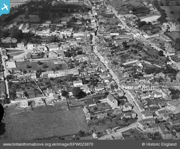
EPW023870 ENGLAND (1928). Long Street and the town, Wotton-under-Edge, 1928
© Copyright OpenStreetMap contributors and licensed by the OpenStreetMap Foundation. 2025. Cartography is licensed as CC BY-SA.
Nearby Images (7)
EPW023870

EAW017993

EPW023869

EAW017994

EPW023866

EPW023865

EPW023867

Details
| Title | [EPW023870] Long Street and the town, Wotton-under-Edge, 1928 |
| Reference | EPW023870 |
| Date | September-1928 |
| Link | |
| Place name | WOTTON-UNDER-EDGE |
| Parish | WOTTON-UNDER-EDGE |
| District | |
| Country | ENGLAND |
| Easting / Northing | 375752, 193238 |
| Longitude / Latitude | -2.3504160250139, 51.636957400595 |
| National Grid Reference | ST758932 |
Pins

Class31 |
Wednesday 12th of June 2013 12:03:48 PM | |
|
Class31 |
Sunday 21st of October 2012 11:06:39 PM | |
|
Class31 |
Sunday 21st of October 2012 11:03:43 PM | |
|
Class31 |
Tuesday 16th of October 2012 10:52:17 PM | |
|
Class31 |
Tuesday 16th of October 2012 10:51:50 PM | |
|
Class31 |
Tuesday 16th of October 2012 10:50:54 PM | |
Rowland Hill Almshouses |
Class31 |
Sunday 21st of October 2012 11:05:54 PM |
These are the Perry Dawes Almshouses. Built C.1630. Inside the quadrangle is a small non-denominational chapel. Built at the same time |

maddy |
Thursday 16th of February 2017 08:39:16 PM |
|
Class31 |
Tuesday 16th of October 2012 10:50:34 PM | |
|
Class31 |
Tuesday 16th of October 2012 10:50:11 PM | |
|
Class31 |
Tuesday 16th of October 2012 10:49:50 PM | |
|
Class31 |
Tuesday 16th of October 2012 10:48:57 PM | |
|
Class31 |
Tuesday 16th of October 2012 10:48:38 PM | |
|
Class31 |
Tuesday 16th of October 2012 10:48:19 PM | |
|
Class31 |
Tuesday 16th of October 2012 10:47:57 PM | |
|
Class31 |
Tuesday 16th of October 2012 10:47:37 PM | |
|
Class31 |
Tuesday 16th of October 2012 10:47:16 PM |