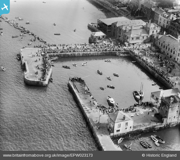
EPW023173 ENGLAND (1928). The Town Quay, Falmouth, 1928
© Copyright OpenStreetMap contributors and licensed by the OpenStreetMap Foundation. 2026. Cartography is licensed as CC BY-SA.
Nearby Images (14)
Details
| Title | [EPW023173] The Town Quay, Falmouth, 1928 |
| Reference | EPW023173 |
| Date | 1-September-1928 |
| Link | |
| Place name | FALMOUTH |
| Parish | FALMOUTH |
| District | |
| Country | ENGLAND |
| Easting / Northing | 181136, 32588 |
| Longitude / Latitude | -5.0641386283709, 50.152257677948 |
| National Grid Reference | SW811326 |
Pins
Be the first to add a comment to this image!


![[EPW023173] The Town Quay, Falmouth, 1928](http://britainfromabove.org.uk/sites/all/libraries/aerofilms-images/public/100x100/EPW/023/EPW023173.jpg)
![[EPW023181] The Town Quay and North Quay, Falmouth, 1928](http://britainfromabove.org.uk/sites/all/libraries/aerofilms-images/public/100x100/EPW/023/EPW023181.jpg)
![[EPW023179] The Town Quay and North Quay, Falmouth, 1928](http://britainfromabove.org.uk/sites/all/libraries/aerofilms-images/public/100x100/EPW/023/EPW023179.jpg)
![[EPW023172] The Town Quay and North Quay, Falmouth, 1928](http://britainfromabove.org.uk/sites/all/libraries/aerofilms-images/public/100x100/EPW/023/EPW023172.jpg)
![[EPW023174] The Town Quay, Falmouth, 1928](http://britainfromabove.org.uk/sites/all/libraries/aerofilms-images/public/100x100/EPW/023/EPW023174.jpg)
![[EPW023183] The Town Quay, Falmouth, 1928](http://britainfromabove.org.uk/sites/all/libraries/aerofilms-images/public/100x100/EPW/023/EPW023183.jpg)
![[EPW023184] The Town Quay, Falmouth, 1928](http://britainfromabove.org.uk/sites/all/libraries/aerofilms-images/public/100x100/EPW/023/EPW023184.jpg)
![[EPW023185] The Town Quay, Falmouth, 1928](http://britainfromabove.org.uk/sites/all/libraries/aerofilms-images/public/100x100/EPW/023/EPW023185.jpg)
![[EPW023180] The Town Quay, Falmouth, 1928](http://britainfromabove.org.uk/sites/all/libraries/aerofilms-images/public/100x100/EPW/023/EPW023180.jpg)
![[EPW023182] The Town Quay, Falmouth, 1928](http://britainfromabove.org.uk/sites/all/libraries/aerofilms-images/public/100x100/EPW/023/EPW023182.jpg)
![[EPW023175] The Town Quay, Falmouth, 1928](http://britainfromabove.org.uk/sites/all/libraries/aerofilms-images/public/100x100/EPW/023/EPW023175.jpg)
![[EPW023177] The Town Quay, Falmouth, 1928](http://britainfromabove.org.uk/sites/all/libraries/aerofilms-images/public/100x100/EPW/023/EPW023177.jpg)
![[EPW023178] The Town Quay and Arwenack Street, Falmouth, 1928](http://britainfromabove.org.uk/sites/all/libraries/aerofilms-images/public/100x100/EPW/023/EPW023178.jpg)
![[EPW021723] Wodehouse Terrace, the Town Dock and environs, Falmouth, 1928](http://britainfromabove.org.uk/sites/all/libraries/aerofilms-images/public/100x100/EPW/021/EPW021723.jpg)